Keatley Creek Archaeological Site

Last updated

Keatley Creek is a significant archaeological site in the interior of British Columbia and in the traditional territory of the St'at'imc peoples. Its location is in the Glen Fraser area of the Fraser Canyon ranchlands about 18 miles from the town of Lillooet on a benchland flanking Keatley Creek, whose name derives from a former ranch owner, and from which the site takes its name.

Contents

The site is home to more than 115 pit house (quiggly hole or kekuli) depressions, left from semi-subterranean wooden dwellings, some of which would have been 18 to 21 meters in diameter. The site is one of the largest and well-studied house pit village sites in Canada, home to some of the biggest house pit depressions in the archaeological record.

Researchers believe that the site was first inhabited as early as 7,000 Before Present. A large complex community whose economy centered around gathering, fishing, and hunting began developing from 4,800 BP. The Keatley Creek site blossomed from around 2,400 BP with a population of about 1,000 people. At this time the network of villages in the Mid-Fraser region would have been one of the largest pre-contact aboriginal communities in the modern borders of Canada. Although there is continued debate about the site's occupation and abandonment or depopulation, the community was vacated perhaps as early as 1,000 BP or as late as 800 BP, as were the other neighboring villages. Rock slide stopped the fish run and we had to relocate to pavilion or fountain. No decisive evidence has been found of either warfare or a devastating epidemic, although this as well as an environmental catastrophe or climate change have all been theorized, and aboriginal peoples continued living throughout the region.

Keatley Creek holds a special heritage importance to First Nations communities. Since the mid-1980s the site has also been the subject of the Simon Fraser University's Fraser River Investigations into Corporate Group Archaeology Project, led by Brian Hayden, as well as other research projects led by Anne Marie Prentiss. It is now a provincially recognized cultural heritage area and also gaining international attention through interest at a UNESCO research forum.

Overview

Location

The Keatley Creek Site (Borden Number EeR17) is an archaeological excavation site in southwestern British Columbia, Canada, and is today located within the traditional territory of the St'at'imc First Nation. The site is situated on the British Columbia Plateau (also known as the Canadian Plateau) about 25 km upstream along the Fraser River [1] in what is called the Middle Fraser Canyon or "Mid-Fraser". [2] The site is between the St'at'imc communities of Xaxli'p (Fountain) and Ts'kw'aylaxw (Pavilion). [3] The closest town is Lillooet.

Keatley Creek is "...nestled in a small basin at the back edge of a Pleistocene river terrace, where it meets the mountain slope over 1,200 ft. (360 m) above the Fraser River" [4] on terrain described as "benchlands above the Fraser River gorge". [1]

The village was close to many other small and medium communities including the down-river villages of Seton Lake (EeRl-21), Lillooet, Bridge River (EeRl-4), Fountain and Bell (EeRk-4), as well as, upriver, Pavilion, McKay Creek (EfRl-3 and −13), Chicken Gully (EfRl-5), and Kelly Creek/Pełtêqet (EfRk 1 and EfRl 25). Several of these villages (including Lillooet, Fountain and Pavilion) have now been destroyed. Of the remaining Plateau Pithouse Tradition house pit village settlements in the Mid-Fraser region, only the Kelly Creek and Keatley Creek sites have more than one hundred depressions, although large villages (with over 130 depressions) have also been identified along the Upper Chilcotin, South Thompson, and Slocan River. This so-called zenith in the population is known as the Classic Lillooet Phase, [5] where the villages existed in some form of network—either relatively autonomously or with multi-village communities.

Site

The site itself stretches over a kilometer, with the core area with the greatest concentration of house pits covering in a four hectare radius. [1] The site supported a lengthy period of human occupation, and was one of the largest villages in the Mid-Fraser region. [6] Earliest carbon dating puts initial occupation around 7,000–8,000 BP. The site was more or less consistently occupied from the Shuswap horizon (2400–4000 BP) through the Plateau horizon (1200–2400 BP) and into the early Kamloops horizon (1200 BP). [6]

The site features include 119 house depressions, [1] called a house pits or quiggly holes (kekuli or kickwillie). Keatley Creek is "known for the unusually large size of its semi-subterranean houses" [6] some more than 20 meters in diameter, although many are no larger than 5 meters. [7] Archaeological investigation has concluded the Keatley Creek area was occupied by "residential corporate groups of differing economic and social status" [1] which can also be described as a transegalitarian community.

Village life

At its peak population (c. 700 A.D.), Keatley Creek's population numbered over 700 people and probably around 1,000. [7] Tools, baskets and hunting weapons found in excavations of Keatley Creek indicate that its ancient inhabitants had been the Stl'atl'imx, a Salish-speaking people [8] who were gatherer-hunter-fishers living during the cold winter months in pit houses, and engaging in a variety of forms of food storage that included both harvest and material storage, and husbandry of one domesticated animal, the dog. [4] Life in the ancient village continues to capture people's interest and imagination. The house pit village in some ways lends itself to the creation of a material history, as Anne Marie Prentiss explains:

Housepit villages such as Keatley Creek and Bridge River developed over hundreds of years. The archaeological record of many housepits formed through regular reoccupations organized around cleaning and rebuilding activities. An early researcher in this area, James Teit recorded that people constructed them by first digging a pit and then acquiring wood for upright posts and horizontal beams. The wood superstructure was then built by using strong upright posts to support the horizontal beams. Layers of timbers and matting covered the roof, and in some cases sediments sealed the construction, offering extra insulation. People dug pits indoors and lined them with birch bark to store food. They constructed hearths and made benches and storage platforms. Aside from regular cleaning, a family could live in such a house for up to 20 years without significant architectural modification. At some point, however, wood would become dangerously old, and vermin could infest portions of the roof and floor. In these cases, good timbers would be salvaged and the old roof burned down. Families returning from late warm-season food-gathering trips would then rebuild roofs and floors before they re-inhabited the houses. Sometimes rebuilding involved removing all of the burned roof materials and scraping out the old floors. At other times, as with many Bridge River houses, the people would remove burned and collapsed roof materials but not the floors. Instead, they would import new sediments and dump them over the old floors, thereby preserving an even more detailed record of household life over multiple generations. [8]

It is worth noting that the Keatley Creek and Bridge River sites have some differences in housepit formation. At Keatley, houses generally consist of the final inhabitant's floor; previous floors and roofs are re-deposited on rims. [9]

Keatley Creek society was part of the spectrum of complex gatherer-hunter-fisher societies. Such sedentism is widespread in the archaeological record (such as the Middle Jōmon culture of Japan, the northern European Mesolithic, the Natufian of the Near East, the Thule tradition of North America's Western Arctic, etc.). At the same time, the pithouse villages along the Mid-Fraser are arguably "among the largest hunter-gatherer settlements recorded anywhere in the world for any period. They are much larger than most, if not all, prehistoric villages on the adjacent Northwest Coast. The only precontact settlements of comparable size within the modern borders of Canada were the horticultural Iroquoian villages of southern Ontario." [5]

Dynamic seasonal round

Archaeologists have argued for at least a basic level of cultural continuity in the region, noting the consistency between traditional knowledge, oral and written historical records with the archaeological evidence. This suggests that the yearly round or seasonal life movements of the inhabitants of Keatley Creek were likely in general accord with those recorded in traditional ethnography. Hayden and Spafford suggest:

In the fall, large stores of salmon would be caught and dried along the Fraser River for winter food. After the fishing ended, the major deer hunt of the year took place in the alpine meadows. When cold weather set in, everyone would retreat to winter villages on the terraces of the Fraser River, where fish, meat, and plant foods were stored. During the winter, families lived in pithouses dug partly into the ground and covered with a conical wooden roof on which soil and sediment was piled for insulation, much like the roof of historical sod-covered cabins. Entry was generally via a ladder protruding through the smoke hole of the roof; and we think that people were relatively tightly bunched together in these houses for warmth during the frigid winters. By March, the people were anxious to move into the open and began to look for the first edible plant shoots and bulbs, such as young raspberry shoots and wild onions. Spring was often a time of hunger if winter food stores had been used up, and the first signs of spring salmon were eagerly awaited. When the snows had cleared in the mountains, most groups went to dig spring beauty corms ("mountain potatoes") and mountain lilies, as well as hunt and fish in the mountain lakes (Alexander 1992). In mid to late summer, people gathered saskatoon and other berries as they ripened at lower elevations. By late summer, everyone was back down at the river fishing sites preparing fish for the winter and trading with visitors. [4]

Therefore, although a critical amount of nutrition came from gathered foods (plants, geophytes or roots and tubers, and berries) and deer also supplemented nutrition, salmon fishery was a key source of nutrients. [4] Trade and exchange for dried salmon also brought together goods from considerable distances away, like ground stone bowls, obsidian, and nephrite jade. Sockeye, Chinook, Chum and Coho salmon were available from August to October and were caught, dried, and stored for later use throughout the winter.

Chinook and Sockeye were, in the ethnographic record, preferred over Chum and Coho because of their stronger, richer flavor, although they also take longer to dry. [10] Salmon DNA studies show that during the period Keatley Creek was inhabited, pink salmon, a fish known as easy to catch and easy to dry, were absent from the region. [10]

At the same time, palynology, alluvial stratigraphy, paleo-oceanography, and studies of pre-history now show the climate, and likely also the seasonal round, varied significantly in the region with a dry interval (2,200 to 1,600 BP) followed by a cool, moist time (1,600 to 1,200 BP) and then return to dry interval, corresponding with the Medieval Warm Period. These changes would have also affected salmon populations, with growth in the salmon population during the cooler, moist era and reduction during the warmer periods. [9]

Social organization

The presence of somewhat unequal pit house sizes, storage pits, as well as differences in the type and quality of dietary and lithic (stone tool) remains, have meant that Keatley Creek has become an important archaeological site in debates about the development of social inequality.

Initial research formulated that "mass harvest and storage permitted sedentism and inequality in natural abundances led to social inequalities." [11] Certainly, winter survival relied on extensive use of food storage, which became all the more real as the population of Keatley Creek grew. Storage technologies in the mid-Fraser were varied and included cache pits, above-ground facilities, baskets, and cords. [11]

In this direction, three types of "corporate groups" were reportedly identified in the Keatley Creek village: several families living in the same structure, an individual family in its own structure, and large amorphous residential groups assembled, such as a neighborhood. [12] Studies indicate an early socioeconomic strategy [7] and signs of sociopolitical complexity suggesting domestic subgroups within households and within the community at large, especially in the final centuries of Keatley Creek's occupation. [2] The biggest dwellings have the largest storage capacity, more prestige foods (i.e. chinook salmon) and lithics such as obsidian, steatite and nephrite which would have been difficult to obtain. Following from this analysis, the four largest pit homes represent the accommodations of multi-household clans or otherwise higher status social groups. Dogs were also kept by higher status dwellings for "hunting, transportation, protection and companionship, clothing (hides), weaving materials (hair), ritual, and food." [11]

Subsequent research has reconsidered the relationship between economic stratification and salmon species distribution at Keatley Creek as "visible but clearly not as dramatic as previously assumed" [10] because of the over-all prevalence of chinook salmon. Some archaeologists have also suggested that social stratification took place not during a moment of population growth, but social contraction due to internal or external contradictions facing Keatley Creek. [8] Therefore, "the pattern of inequality was not triggered by any major technological changes or expansions in per-capita storage. Rather, it appears to have come as a consequence of households changing the rules of food sharing and consumption under stressful conditions." [11]

Excavation and research

Keatley Creek has been the site of active excavations from 1986 and ongoing in 2013–present. [4] The main projects have been led by Brian Hayden and Anna Marie Prentiss.

Hayden Project

In 1986, Brian Hayden of Simon Fraser University, British Columbia, began the initial project at Keatley Creek. That study's initial aim was to "determine why this site was so large and why some of the individual semisubterranean housepits were also unusually big." [4] Hayden's group was also interested in the cultural continuity in the region [4] and exploring houses where multiple families lived in what were described as "residential corporate groups" [4] Hayden's expedition examined the botanical, faunal, and lithic remains at the site [13] and explored the formation of different types of strata and construction, closely examining floors, roofs, middens, and hearths. They sought to identify activities and social habits that occurred at Keatley Creek through examining stone artifacts and debitage (waste products from manufacture). [13] The nature of each structure was examined in order to compare the "economic and social organization" of the residences. [1] Over the years, Hayden's excavations have expanded, and his work continued with varied hypotheses. Ongoing studies have been documented in several publications:

Prentiss Project

Anna Marie Prentiss of the University of Montana has included Keatley Creek in her study of Plateau villages throughout prehistory. She has explored the evolution of variations in the Plateau villages, including the need to draw distinctions between "socioeconomically 'complex' communities and those designated as 'sociopolitically' complex." [7] She anticipated that findings at Keatley Creek would contribute to understanding the distribution of ethnographic cultures in the region. Additionally, her work identified the possibility that the Keatley Creek community had emerged as a "complex collector socioeconomic strategy." [7] Her study of Keatley Creek Site contributes to her exploration of the "rise and fall of human societies during that long time span we call the Archaic." [2] Prentiss' studies have been numerous and documented in several publications such as:

Other projects

Several other subjects of study have involved Keatley Creek Site including (but not limited to):

Keatley Creek housepit sites

The Keatley Creek winter village of housepits (Figures 1 – 3) is geographically positioned near the Fraser River to "protect access to critical salmon resource." The area also provided the village access to a wide array of natural resources (game for hunting, wood for construction, stone for tools). [7]

Basic structural concept

The housepits of Keatley Creek are semi-subterranean structures. [4] Their construction was obviously labor-intensive and provided permanent structures [7] in a generally circular shape with conical or pyramidal roof shapes. [1] Entrance to the housepit was made possible by a log ladder that emerged through an opening located somewhat centrally in the roof [1] protruding through the smoke hole. [4] In general, each housepit affords only 2.5 square meters of floor space per person [4] occupying the space. Pit houses, like other First Nations boreal forest home structures, were environmentally friendly leaving almost no footprint on the landscape when abandoned.

Small housepit

Hayden's group tested Housepit 12 – one of the smaller housepits at the Keatley Creek site. It measured 9 meters in diameter (rim crest to rim crest) where most small housepits are 7m in diameter. Compared to other small structures, housepit 12 had a substantial roof, indicating that these residents were not the poorest in the Keatley Creek community, but they were still impoverished compared to the residents of the larger structures at the site. There was little use of the fire hearth, foods required no cooking and were served unheated. It was essential for inhabitants to huddle for warmth. In this site, there was evidence of lower grade foods and clothing. There was very little storage space. The overall space was divided into distinct areas for butchering/eating, stonework and tools, open or communal areas. [4] No distinct areas were reserved for lying down or sleeping, unlike peripheral areas of the larger housepits. [1]

Medium housepit

Hayden's excavation included Housepit No. 3, which measured 14 meters in diameter. It is estimated that thirty people (i.e., five or six nuclear families) occupied this structure. Deposits here indicate some elements of wealth, larger storage pits, some higher grade food products, and probable access to better fishing sites than the residents of the smaller housepits. [4] The wood used for fuel was the same type as for the small housepit, but here was evidence of greater use of fire and of the hearths. [1] There were bedding materials at the peripheral walls with some raised sleeping platforms signifying another difference from the residents of the smaller structures. The medium-sized housepit included separate domestic spaces with a central communal area. The overall space was divided into four sectors with a principal hearth in central area. [4]

Large housepit

The large housepit was especially important to Hayden's study of residential corporate groups and how the artifacts and assemblages could be used to compare the life practices of people living in the larger structures with those in the smaller size housepits. [4] Hayden's team excavated Housepit #7 which measured 19 meters in diameter from rim crest to rim crest. They estimated that at least 45 people lived in this structure at one time—perhaps eight separate families or domestic units. The deposits found here indicated that these occupants enjoyed substantial economic resources and wealth compared to the residents of small structures. Higher grade construction materials and processes were employed. There were multiple hearths used regularly, some of them unusually large. Per capita storage areas were far larger and more numerous than those of other housepits. [4] High quality foods were available including more meat products (such as fox, bear, and sheep) and some unexpected species (such as scallops which would have been obtained in trade from the coast). [1] These occupants had access to a wide array of wealth items. Overall, they were economically well off. It is possible that they even had dogs as pets. [4] Separate domestic units in the large housepit each contained hearths, tools, comforts, and conveniences. The structure held a central communal area with an especially large hearth. The division of the overall space indicates the possibility of sexual division of workspaces and for a "fundamental socioeconomic division" within the structure – perhaps including controlling families and tenant families or those who worked for the household. [4] It is possible that some members of this household held high status in the community at large. [1] Evidence indicates that the major housepits were continuously occupied over several generations, perhaps more than 1,000 years, by "a single, identifiable social group" which maintained the structure's roof, storage areas, and basic organization. [1] It is remarkable that these households were able to successfully replenish themselves by recruiting new members over such a long period. [12]

Other structures

Of the 119 housepits noted at Keatley Creek, some were apparently used as storage facilities of varying sizes (some quite large). Also evident are communal roasting pits outside of the residential structures. [7]

Debate about occupation and abandonment

Some controversy surrounds the dates of Keatley Creek's occupation and the reason for its depopulation. The debate is frustrated partly by the margin of error associated with radiocarbon dating. What is agreed by all researchers is that long before contact and colonization the large villages had disappeared—although the local area was never abandoned by indigenous peoples and, before contact and colonization, the indigenous population rose again. As the villages in the mid-Fraser Canyon contained one of the highest population densities in the Pacific Northwest, their breakup must have had significant repercussions for social life throughout the entire region. In identifying the exact reason, or reasons, for that change there is less consensus.

To be sure, not all researchers agree the site was continuously inhabited, nor do they agree on how or why the social communities came together. Two main proposals have been formulated: Hayden emphasizes technological development, and Prentiss' emphasizes environmental factors and limitations.

Early occupancy and catastrophe

Hayden places Keatley Creek's occupancy as beginning in 2,600 BP and ending in 1,000 BP (ca 400 BC – 1000 AD). [4] The villages came together at a moment which allowed for technological improvements to allow for the production of food surpluses through salmon harvest, and with the development of competitive feasting, social inequality emerged.

The villages were long-lived until a serious problem with the salmon population arose, leading to abandonment in 1000 AD. This is when a single catastrophic event — a massive rockslide below Lillooet at Texas Creek — destroyed salmon runs in the Fraser and creating a sudden crisis for Keatley Creek residents. [15] The slide would have created a long-lasting dam for salmon, preventing access to necessary spawning beds.

The exact date of the Texas Creek slide is unclear, as is evidence of a large backed-up lake. These and other problems have been cited with Hayden's thesis.

Waves of population growth reach limits

Prentiss, on the other hand, estimates that occupancy was from 1,700 BP to 800 BP [2] (ca 300–1200 AD [15] ). Significant climatic warming was taking place during the initial period of village formation, increasing vegetation and likely decreasing the salmon population. Small village formation was driven by resource scarcity and a need to come together to conserve the salmon resources. A complex process of cultural transmission associated with population expansion took place later, when the climate shifted to be more favorable for salmon. Later, depopulation took place in two waves, around 800 BP [7] (1200 AD [15] ) associated with climatic deterioration during the Medieval warm period [15] or the "early Neoglacial period." Stress on these communities was probably exacerbated by resource exhaustion of local roots and tubers. Dietary records suggest that people searched for food further afield from the villages and had more reliance on lower-quality food such as seeds. The complexity of hunting tools indicated that more diverse species of animals also were hunted further afield. This adds up to a "Malthusian ceiling" associated with reduction in critical subsistence resources, social change, and eventual village abandonment. [7] [8]

War, plague, crisis

Morin, who published radiocarbon dates of material at the house pits sites, concluded that the highest population densities were between 1,550–1,150 BP (400 AD and 800 AD) with a maximum around 1,200 BP (700 AD). He argues that Keatley Creek's drastic population decline began in the ninth century. By 950 BP (1000 AD) the Keatley Creek Site's population was barely half that of three centuries before. [15] Also skeptical of a single catastrophic crisis, Morin also looks at internal contradictions in Mid-Fraser society. Although little evidence exists for warfare, it may have increased with the introduction of the bow and arrow, as elsewhere in the interior plains. Morin and others have suggested as well that variability in salmon populations could have been coupled with the reality that more densely settled population is vulnerable to disease. [5]

Perhaps summarizing the common ground in the discussion, Morin and others have written:

Rather than a static, timeless picture of the aboriginal past, research in the Mid-Fraser offers a glimpse of the rich history of these peoples and their settlements [like Keatley Creek]. Briefly, this history included the development of many large villages with population densities along the Mid-Fraser greatly exceeding those at contact or even today and the abandonment of such settlements at least six centuries before contact. The history of these communities was undoubtedly marked by the founding of new villages; the rise and fall of powerful lineages and chiefs; the shifting of alliances between chiefs, lineages, villages, and distant trading partners; the spread of new technologies and rituals; periods of strife and peace; and others of plenty and dearth. Although archaeology can illuminate no more than an outline of this rich and varied history, researchers will continue to question current understandings of and add information about the long and extraordinary human past of this remarkable region.

Heritage resource classification

The significance of Keatley Creek's cultural heritage is especially true for local First Nations peoples, who have striven to overcome over a century of colonial policies aimed at forms of cultural destruction and genocide, and to reclaim their history, language and identities, as well as sovereignty and self-determination.

Since Keatley Creek was home to a large community for an extremely long time, it is extremely important for archaeological study, representing the culmination of centuries of human experimentation with housepit living. [7] The site contributes to the bank of knowledge regarding North American history and communities. It suggests a past that was more socioeconomically or politically complex and more culturally diverse than previously recorded. [2] Today the site is also recognized as a special heritage resource for the province of British Columbia. [4]

Keatley Creek has also been described as "a world heritage quality site." [13] It earned this distinction not only because its excavation is important for understanding the development of complex hunting and gathering cultures [4] but also because it is well preserved, clearly visible, and easily accessed from a nearby highway. [4] The Keatley Creek Site includes well-defined architectural features and provides valuable evidence of complex socioeconomic organization. [13] Recently, the site has earned attention at a UNESCO conference hosted as part of its 2013 World Heritage Thematic Programme, at Biblioteca Palafoxiana in Mexico City.

Related Research Articles

<span class="mw-page-title-main">Lillooet</span> District municipality in British Columbia, Canada

Lillooet is a district municipality in the Squamish-Lillooet region of southwestern British Columbia. The town is on the west shore of the Fraser River immediately north of the Seton River mouth. On BC Highway 99, the locality is by road about 100 kilometres (62 mi) northeast of Pemberton, 64 kilometres (40 mi) northwest of Lytton, and 172 kilometres (107 mi) west of Kamloops.

<span class="mw-page-title-main">Stʼatʼimc</span> Salishan ethnic group of British Columbia, Canada

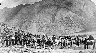
The Stʼatʼimc, also known as the Lillooet, St̓át̓imc, Stl'atl'imx, etc., are an Interior Salish people located in the southern Coast Mountains and Fraser Canyon region of the Interior of the Canadian province of British Columbia.

<span class="mw-page-title-main">Indigenous peoples of the Northwest Plateau</span> Regional culture in North America

Indigenous peoples of the Northwest Plateau, also referred to by the phrase Indigenous peoples of the Plateau, and historically called the Plateau Indians are Indigenous peoples of the Interior of British Columbia, Canada, and the non-coastal regions of the Northwestern United States.

<span class="mw-page-title-main">Fraser Canyon</span> Canyon in British Columbia, Canada

The Fraser Canyon is a major landform of the Fraser River where it descends rapidly through narrow rock gorges in the Coast Mountains en route from the Interior Plateau of British Columbia to the Fraser Valley. Colloquially, the term "Fraser Canyon" is often used to include the Thompson Canyon from Lytton to Ashcroft, since they form the same highway route which most people are familiar with, although it is actually reckoned to begin above Williams Lake at Soda Creek Canyon near the town of the same name.

<span class="mw-page-title-main">Pit-house</span> Type of earth shelter with ancient origins

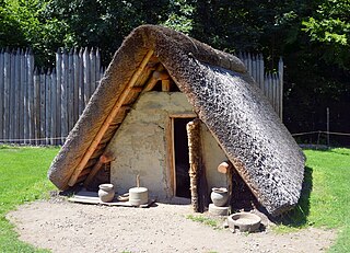
A pit-house is a house built in the ground and used for shelter. Besides providing shelter from the most extreme of weather conditions, this type of earth shelter may also be used to store food and for cultural activities like the telling of stories, dancing, singing and celebrations. General dictionaries also describe a pit-house as a dugout, and it has similarities to a half-dugout.

<span class="mw-page-title-main">Marble Canyon (British Columbia)</span>

Marble Canyon is in the south-central Interior of British Columbia, a few kilometres east of the Fraser River and the community of Pavilion, midway between the towns of Lillooet and Cache Creek. The canyon stems from a collapsed karst formation.

<span class="mw-page-title-main">Interior Plateau</span> Region in Interior of British Columbia, Canada

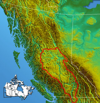
The Interior Plateau comprises a large region of the Interior of British Columbia, and lies between the Cariboo and Monashee Mountains on the east, and the Hazelton Mountains, Coast Mountains and Cascade Range on the west. The continuation of the plateau into the United States is known there as the Columbia Plateau.

<span class="mw-page-title-main">Camelsfoot Range</span> Sub-range of the Chilcotin Ranges in British Columbia, Canada

The Camelsfoot Range is a sub-range of the Chilcotin Ranges subdivision of the Pacific Ranges of the Coast Mountains in British Columbia. The Fraser River forms its eastern boundary. The range is approximately 90 km at its maximum length and less than 30 km wide at its widest.

<span class="mw-page-title-main">Quiggly hole</span> Remains of an earth lodge built by First Nations people

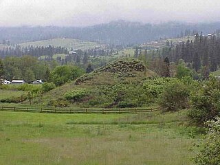
A quiggly hole, also known as a pit-house or simply as a quiggly or kekuli, is the remains of an earth lodge built by the First Nations people of the Interior of British Columbia and the Columbia Plateau in the United States. The word quiggly comes from a mispronunciation of the nsyilxcǝn term qʷc̓iʔ, which was incorporated into Chinook Jargon as kickwillie. Kick willy, kickwillie, or keekwulee are the spelling variations of the Chinook Jargon word for "beneath" or "under".

N'Quatqua, variously spelled Nequatque, N'quat'qua, is the proper historic name in the St'at'imcets language for the First Nations village of the Stl'atl'imx people of the community of D'Arcy, which is at the upper end of Anderson Lake about 35 miles southeast of Lillooet and about the same distance from Pemberton. The usage is synonymous with Nequatque Indian Reserve No. 1, which is 177 ha. in size and located adjacent to the mouth of the Gates River.

Oshara Tradition, the northern tradition of the earlier Picosa culture, was a Southwestern Archaic tradition centered in the area now called New Mexico and Colorado. Cynthia Irwin-Williams developed the sequence of Archaic culture for Oshara during her work in the Arroyo Cuervo area of northwestern New Mexico. Irwin contends that the Ancestral Puebloans developed, at least in part, from the Oshara.

<span class="mw-page-title-main">Fountain, British Columbia</span>

Fountain is an unincorporated rural area and Indian reserve community in the Fraser Canyon region of British Columbia, Canada, located at the ten-mile (16 km) mark from the town of Lillooet on BC Highway 99, which in that area is also on the route of the Old Cariboo Road and is located at the junction of that route with the old gold rush-era trail via Fountain Valley and the Fountain Lakes.

The Hoko River Archeological Site complex, located in Clallam County in the northwestern part of the U.S. state of Washington, is a 2,500-year-old fishing camp. Hydraulic excavation methods, which were first developed on the site, and artifacts found there have contributed to the understanding of the traditions and culture of the Makah people who have inhabited the northwest for 3,800 years. The site has also shed light on the evolution of food storage and the flora and fauna that existed in the area around 2500 B.P. Its name comes from the Hoko River.

The Bridge River Rapids, also known as the Six Mile Rapids, the Lower Fountain, the Bridge River Fishing Grounds, and in the St'at'imcets language as Sat' or Setl, is a set of rapids on the Fraser River, located in the central Fraser Canyon at the mouth of the Bridge River six miles north of the confluence of Cayoosh Creek with the Fraser and on the northern outskirts of the District of Lillooet, British Columbia, Canada.

Jeanne E. Arnold was an American archaeologist who taught in the anthropology department at the University of California, Los Angeles. Her fields of research covered many topics, but she specialized in the prehistoric and early contact era of the Pacific Coast of North America, in California and British Columbia. Her work in these areas was directed to resolving the economies and political evolutionary trajectories of complex hunter-gatherer groups. She died on November 27, 2022, following a long illness.

<span class="mw-page-title-main">Basketmaker III Era</span> Ancient culture of the southwest United States

The Basketmaker III Era also called the "Modified Basketmaker" period, was the third period in which Ancient Pueblo People were cultivating food, began making pottery and living in more sophisticated clusters of pit-house dwellings. Hunting was easier with the adoption of the bow and arrow.

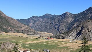
Keatley Creek is a left tributary of the Fraser River in the Glen Valley area of the Fraser Canyon in the Interior of British Columbia, Canada. Its outlet into the Fraser is between those of Pavilion and Fountain Creeks, approximately 16 miles upstream from the town of Lillooet; the next tributary southwards is the larger Sallus Creek.

Texas Creek is a medium-sized right tributary of the Fraser River in the Fraser Canyon region of that river's course, located approximately 16 miles down the river from the town of Lillooet. Texas Creek is also the name of the rural neighbourhood in the area of the creek, and also that of the Texas Creek Ranch which is one of the larger holdings.

Glen Fraser is a locality in the central Fraser Canyon of the Central Interior of British Columbia, Canada, located c. 18 miles north of the town of Lillooet and between the communities of Fountain (S) and Pavilion. It is a ranching area formed of benchlands on the west side of the Fraser and is the location of the Keatley Creek Archaeological Site, one of Canada's most important ongoing investigations. The name was conferred as that of a railway stop on the Pacific Great Eastern Railway, now Canadian National.

Whittlesey culture is an archaeological designation for a Native American people, who lived in northeastern Ohio during the Late Precontact and Early Contact period between A.D. 1000 to 1640. By 1500, they flourished as an agrarian society that grew maize, beans, and squash. After European contact, their population decreased due to disease, malnutrition, and warfare. There was a period of long, cold winters that would have impacted their success cultivating food from about 1500.

References

  1. 1 2 3 4 5 6 7 8 9 10 11 12 13 14 15 Lertzman, Kenneth P. "Reconstructing prehistoric socioeconomies from paleoethnobotanical and zooarchaeological data: an example from the British Columbia Plateau." Journal of Ethnobiology 16.1 (1996): 31–62.
  2. 1 2 3 4 5 Prentiss, Anna Marie. "Imagining the archaic." SAA Archaeological Record (2008): 31.
  3. P'egp'íg7lha Clan. "Homepage." http://www.titqet.org Accessed Dec. 29/2014
  4. 1 2 3 4 5 6 7 8 9 10 11 12 13 14 15 16 17 18 19 20 21 22 Hayden, Brian, and Jim Spafford. "The Keatley Creek site and corporate group archaeology." BC Studies: The British Columbian Quarterly 99 (1993): 106–139.
  5. 1 2 3 Morin, Jesse, Ryan Dickie, Takashi Sakaguchi, and Jamie Hoskins. "Late Prehistoric settlement patterns and population Dynamics along the Mid-Fraser." BC Studies 160 (Winter 2008/09): 9–34
  6. 1 2 3 4 Middleton, William D., and T. Douglas Price. "Identification of activity areas by multi-element characterization of sediments from modern and archaeological house floors using inductively coupled plasma-atomic emission spectroscopy." Journal of Archaeological Science 23.5 (1996): 673–687.
  7. 1 2 3 4 5 6 7 8 9 10 11 12 13 Prentiss, Anna Marie. "The winter village pattern on the Plateau of Northwestern North America." The Oxford Handbook of North American Archaeology (2012): 173
  8. 1 2 3 Prentiss, Anna Marie and Ian Kuijt. People of the Middle Fraser Canyon: An Archaeological History Vancouver: UBC Press, 2012
  9. 1 2 Prentiss, Anna, James C. Chatters, Natasha Lyons, Lucille E. Harris. "Archaeology in the Middle-Fraser Canyon British Columbia Changing Perspectives on Paleoecology and Emergent Cultural Complexity." Canadian Journal of Archaeology 35 (2011): 143–174
  10. 1 2 3 Lertzman, Kenneth P. "Ancient DNA investigation of prehistory salmon resource utilization at Keatley Creek, British Columbia, Canada." Speller, Camilla F., Dongya Y. Yang, Brian Hayden. Journal of Archaeological Science 32 (2005) 1378–1389
  11. 1 2 3 4 Prentiss, Anna, Hannah S. Cailb, Lisa M. Smith. "At the Malthusian ceiling Subsistence and inequality at Bridge River British Columbia." Journal of Anthropological Archaeology 33 (2014):34–48
  12. 1 2 3 4 5 6 Ames, Kenneth M. "Thinking about household archaeology on the Northwest Coast." Household archaeology on the Northwest Coast (2006): 16–36.
  13. 1 2 3 4 Hayden, Brian, and Simon Fraser University. Dept. of Archaeology. The ancient past of Keatley Creek. Burnaby, BC: Archaeology Press, 2000.
  14. Butler, Virginia L., and James C. Chatters. "The role of bone density in structuring prehistoric salmon bone assemblages." Journal of Archaeological Science 21.3 (1994): 413–424.
  15. 1 2 3 4 5 6 Harris, Cole. "Introduction: Considering the Middle Fraser." BC Studies: The British Columbian Quarterly 160 (2008): 3–8.

Selected resources

Books and monographs

Papers