Related Research Articles
First Nations is a term used to identify those Indigenous Canadian peoples who are neither Inuit nor Métis. Traditionally, First Nations in Canada were peoples who lived south of the tree line, and mainly south of the Arctic Circle. There are 634 recognized First Nations governments or bands across Canada. Roughly half are located in the provinces of Ontario and British Columbia.
In Canada, an Indian reserve is specified by the Indian Act as a "tract of land, the legal title to which is vested in Her Majesty, that has been set apart by Her Majesty for the use and benefit of a band."

Chipewyan or Denesuline is the language spoken by the Chipewyan people of northwestern Canada. It is categorized as part of the Northern Athabaskan language family. Dënësųłinë́ has nearly 12,000 speakers in Canada, mostly in Saskatchewan, Alberta, Manitoba and the Northwest Territories. It has official status only in the Northwest Territories, alongside 8 other aboriginal languages: Cree, Tlicho, Gwich'in, Inuktitut, Inuinnaqtun, Inuvialuktun, North Slavey and South Slavey.

The Peace River is a 1,923-kilometre-long (1,195 mi) river in Canada that originates in the Rocky Mountains of northern British Columbia and flows to the northeast through northern Alberta. The Peace River joins the Athabasca River in the Peace-Athabasca Delta to form the Slave River, a tributary of the Mackenzie River. The Finlay River, the main headwater of the Peace River, is regarded as the ultimate source of the Mackenzie River. The combined Finlay–Peace–Slave–Mackenzie river system is the 13th longest river system in the world.

The Métis refers to a group of Indigenous peoples who inhabit Canada's three Prairie Provinces, as well as parts of Ontario, British Columbia, the Northwest Territories, and the Northern United States. They have a shared history and culture and are of mixed Indigenous and European ancestry which became a distinct group through ethnogenesis by the mid-18th century, during the fur trade era.

The Dane-zaa are an Athabaskan-speaking group of First Nations people. Their traditional territory is around the Peace River in Alberta and British Columbia, Canada. Today, about 1,600 Dane-zaa reside in British Columbia and an estimated half of them speak the Dane-zaa language. Approximately 2,000 Dane-zaa live in Alberta.
First Nations in Alberta are a group of people who live in the Canadian province of Alberta. The First Nations are peoples recognized as Indigenous peoples or Plains Indians in Canada excluding the Inuit and the Métis. According to the 2011 Census, a population of 116,670 Albertans self-identified as First Nations. Specifically there were 96,730 First Nations people with registered Indian Status and 19,945 First Nations people without registered Indian Status. Alberta has the third largest First Nations population among the provinces and territories. From this total population, 47.3% of the population lives on an Indian reserve and the other 52.7% live in urban centres. According to the 2011 Census, the First Nations population in Edmonton totalled at 31,780, which is the second highest for any city in Canada. The First Nations population in Calgary, in reference to the 2011 Census, totalled at 17,040. There are 48 First Nations or "bands" in Alberta, belonging to nine different ethnic groups or "tribes" based on their ancestral languages.
The Bigstone Cree Nation is a First Nations band government in Alberta, Canada. As Woodland Cree, they are a western branch of the larger Cree nation, and are a party to Treaty 8 with Canada. The Bigstone Cree Nation was divided into two bands in 2010, with one group continuing under the former name, and the other becoming the Peerless Trout First Nation.
The Tl'etinqox-t'in Government Office is a First Nations government located in the Chilcotin District in the western Central Interior region of the Canadian province of British Columbia. Governing a reserve communities near Alexis Creek known as Anaham Reserve First Nations or Anaham, it is a member of the Tsilhqot'in Tribal Council aka known as the Tsilhqot'in National Government. The main reserve is officially known as Anahim's Flat No. 1, and is more commonly as Anaham. Other reserves are Anahim's Meadow No. 2 and 2A, and Anahim Indian Reserves Nos. 3 through 18. Anaham, or Anahim and Alexis were chiefs of the Tsilhqot'in during the Chilcotin War of 1864, although they and their people did not take part in the hostilities.

The Robson Valley is a geographic region of the Canadian province of British Columbia, comprising the section of the Rocky Mountain Trench that lies southeast of the city of Prince George following the Fraser River to the Yellowhead Pass. The name is derived from Mount Robson, which stands near the entrance to the Yellowhead Pass. Communities in the Robson Valley include the settlements of Dome Creek, Crescent Spur, Dunster, and Tête Jaune Cache, with larger population concentrations in the villages of McBride and Valemount. On a map, the Robson Valley is located immediately south of the elbow in the boundary between Alberta and British Columbia. Transportation corridors through the Robson Valley include the Canadian National Railway lines, and Highways 16 and 5.

Pimicikamak is an indigenous people in Canada. Pimicikamak is related to, but constitutionally, legally, historically and administratively distinct from, the Cross Lake First Nation which is a statutory creation that provides services on behalf of the Canadian Government. Pimicikamak government is based on self-determination and has a unique form.

The West Moberly First Nations is a First Nations located in the Peace River Country in northern British Columbia. They are part of the Dunne-za and Cree cultural and language groups. The West Moberly First Nations used to be part of the Hudson Hope Band, but in 1977 the band split becoming the modern-day Halfway River First Nation and West Moberly First Nations.
Grouard, also known as Grouard Mission, is a hamlet in northern Alberta within Big Lakes County. It was previously an incorporated municipality between 1909 and 1944.
The following is an alphabetical list of topics related to Indigenous peoples in Canada, comprising the First Nations, Inuit and Métis peoples.
RAVEN Respecting Aboriginal Values & Environmental Needs is a charitable organization that provides financial resources to assist Aboriginal nations within Canada in lawfully forcing industrial development to be reconciled with their traditional ways of life, and in a manner that addresses climate change and other ecological sustainability challenges.

The Beaver Lake Cree Nation is a First Nations band government located 105 kilometres (65 mi) northeast of Edmonton, Alberta, representing people of the Cree ethno-linguistic group in the area around Lac La Biche, Alberta, where the band office is currently located. Their treaty area is Treaty 6. The Intergovernmental Affairs office consults with persons on the Government treaty contacts list. There are two parcels of land reserved for the band by the Canadian Crown, Beaver Lake Indian Reserve No. 131 and Blue Quills First Nation Indian Reserve. The latter reserve is shared by six bands; Beaver Lake Cree Nations, Cold Lake First Nations, Frog Lake First Nation, Heart Lake First Nation, Kehewin Cree Nation, Saddle Lake Cree Nation.
Duncan's First Nation is a First Nation in northwestern Alberta, Canada. It operates as an Indian band under the Indian Act representing a community of Aboriginal Canadians, in this case from the Woods Cree ethnic group. The band became a party to Treaty 8 with the Canadian Crown on July 1, 1899. Indian reserves were surveyed for the band in 1905, but the reserves were not confirmed by Order-in-Council until 1907 and 1925. All but one reserves (#151A) were later surrendered to the Canadian government in 1928. One of them, #151K, was later returned to the band in 1965. The two remaining reserves are #151A, located 52 kilometres (32 mi) west of Peace River, Alberta and #151K, located in the McLennon/Reno area, southeast of Peace River. The two reserves comprise a total area of 2,426.1 hectares, and the majority of the population lives on #151A. In 2012, the band had a registered population of 269, of whom 142 members living the band's reserves.
In Canada, the duty to consult and accommodate with Aboriginal peoples arises when the Crown contemplates actions or decisions that may affect Aboriginal or Treaty rights. This duty arises most often in the context of natural resource extraction such as mining, forestry, oil, and gas.
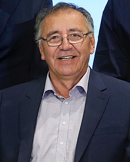
Jim Boucher ( BOO-shay or boo-SHAY; is a Cree and Dene Indigenous Canadian businessman and political leader. As an elected chief, he represented the Fort McKay First Nation, . He established the Fort McKay Group of Companies in 1986, and continued to be chairman and president of the Fort McKay Group of Companies, president of the Athabasca Tribal Council, grand chief of Treaty 8 First Nations of Alberta, vice-chairperson, Board of Governors of Keyano College in Fort McMurray, Alberta, and chairperson for the National Aboriginal Economic Development Board.
References
- ↑ "BC Geographical Names". apps.gov.bc.ca. Retrieved 12 July 2016.
- 1 2 "Recueil des décisions des Cours fédérales - Recherche avancée". April 2011.
- ↑ "Archived copy" (PDF). Archived from the original (PDF) on 2012-10-14. Retrieved 2014-04-16.
{{cite web}}: CS1 maint: archived copy as title (link) - ↑ "Archived copy" (PDF). Archived from the original (PDF) on 2014-04-19. Retrieved 2014-04-17.
{{cite web}}: CS1 maint: archived copy as title (link) - ↑ "Calliou v. Canada - Federal Court".
- ↑ http://www.ceaa-acee.gc.ca/050/documents/p63919/97889E.pdf [ bare URL PDF ]
Coordinates: 55°15′00″N120°02′00″W / 55.25000°N 120.03333°W
| Ethnolinguistic groups | |||||||||||||||||||||||||||
|---|---|---|---|---|---|---|---|---|---|---|---|---|---|---|---|---|---|---|---|---|---|---|---|---|---|---|---|
| Historical polities | |||||||||||||||||||||||||||
| Numbered Treaties | |||||||||||||||||||||||||||
| Tribal councils and band governments |
| ||||||||||||||||||||||||||