Kennedy Meadows (CDP)

Last updated
Kennedy Meadows (CDP)
Tulare County California Incorporated and Unincorporated areas Kennedy Meadows Highlighted 0638076.svg
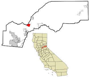
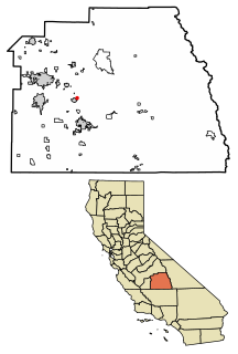
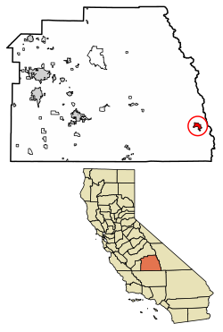
Location of Kennedy Meadows in Tulare County, California.
USA California location map.svg
Red pog.svg
Kennedy Meadows (CDP)
Position in California.
Coordinates: 36°00′28″N118°06′36″W / 36.00778°N 118.11000°W / 36.00778; -118.11000 Coordinates: 36°00′28″N118°06′36″W / 36.00778°N 118.11000°W / 36.00778; -118.11000
Country Flag of the United States.svg  United States
State Flag of California.svg  California
County Tulare
Area
[1]
  Total5.823 sq mi (15.081 km2)
  Land5.823 sq mi (15.081 km2)
  Water0 sq mi (0 km2)  0%
Elevation
[2]
6,214 ft (1,894 m)
Population
 (2010)
  Total28
  Density4.8/sq mi (1.9/km2)
Time zone UTC-8 (Pacific (PST))
  Summer (DST) UTC-7 (PDT)
GNIS feature ID2585427
U.S. Geological Survey Geographic Names Information System: Kennedy Meadows (CDP)

Kennedy Meadows refers to a census-designated place (CDP) in Tulare County, California, United States part of the Springville-Johnsondale CCD, and consists of the community surrounding Kennedy Meadows. [2] The CDP is located to the south-east of the Kennedy Meadows Campground. The 2010 United States census reported Kennedy Meadows's population of permanent residents at 28. [2] The census definition of the area may not precisely correspond to local understanding of the area with the same name.

A census-designated place (CDP) is a concentration of population defined by the United States Census Bureau for statistical purposes only. CDPs have been used in each decennial census since 1980 as the counterparts of incorporated places, such as self-governing cities, towns, and villages, for the purposes of gathering and correlating statistical data. CDPs are populated areas that generally include one officially designated but currently unincorporated small community, for which the CDP is named, plus surrounding inhabited countryside of varying dimensions and, occasionally, other, smaller unincorporated communities as well. CDPs include small rural communities, colonias located along the U.S. border with Mexico, and unincorporated resort and retirement communities and their environs.

Tulare County, California County in California, United States

Tulare County is a county in the U.S. state of California. As of the 2010 census, the population was 442,179. Its county seat is Visalia. The county is named for Tulare Lake, once the largest freshwater lake west of the Great Lakes. Drained for agricultural development, the site is now in Kings County, which was created in 1893 from the western portion of the formerly larger Tulare County.

California State of the United States of America

California is a state in the Pacific Region of the United States. With 39.6 million residents across a total area of about 163,696 square miles (423,970 km2), California is the most populous U.S. state and the third-largest by area. The state capital is Sacramento. The Greater Los Angeles Area and the San Francisco Bay Area are the nation's second- and fifth-most populous urban regions, with 18.7 million and 9.7 million residents respectively. Los Angeles is California's most populous city, and the country's second-most populous, after New York City. California also has the nation's most populous county, Los Angeles County, and its largest county by area, San Bernardino County. The City and County of San Francisco is both the country's second-most densely populated major city after New York City and the fifth-most densely populated county, behind only four of the five New York City boroughs.

Contents

Geography

According to the United States Census Bureau, the Kennedy Meadows CDP covers an area of 5.8 sq mi (15 km2), and is geographically located at the coordinates of 36°00'28.0"N 118°06'36.0"W and an altitude of 6,214 ft (1,894 m).

United States Census Bureau Bureau of the United States responsible for the census and related statistics

The United States Census Bureau is a principal agency of the U.S. Federal Statistical System, responsible for producing data about the American people and economy. The Census Bureau is part of the U.S. Department of Commerce and its director is appointed by the President of the United States.

Demographics

Historical population
CensusPop.
U.S. Decennial Census [3]

The 2010 United States Census [4] reported that Kennedy Meadows had a population of 28. The population density was 4.8 people per square mile (1.9/km²). The racial makeup of Kennedy Meadows was 25 (89.3%) White, 1 (3.6%) Native American, and 2 (7.1%) from other races. Hispanic or Latino of any race were 3 persons (10.7%).

2010 United States Census 23rd national census of the United States, taken in 2010

The 2010 United States Census is the twenty-third and most recent United States national census. National Census Day, the reference day used for the census, was April 1, 2010. The census was taken via mail-in citizen self-reporting, with enumerators serving to spot-check randomly selected neighborhoods and communities. As part of a drive to increase the count's accuracy, 635,000 temporary enumerators were hired. The population of the United States was counted as 308,745,538, a 9.7% increase from the 2000 Census. This was the first census in which all states recorded a population of over half a million, as well as the first in which all 100 largest cities recorded populations of over 200,000.

Population density A measurement of population numbers per unit area or volume

Population density is a measurement of population per unit area or unit volume; it is a quantity of type number density. It is frequently applied to living organisms, and most of the time to humans. It is a key geographical term. In simple terms population density refers to the number of people living in an area per kilometer square.

The Census reported that 28 people (100% of the population) lived in households. There were 15 households, out of which 1 (6.7%) had children under the age of 18 living in them, 9 (60.0%) were opposite-sex married couples living together, and 1 (6.7%) had a female householder with no husband present. There were no unmarried opposite-sex partnerships, and no same-sex married couples or partnerships. 5 households (33.3%) were made up of individuals and 3 (20.0%) had someone living alone who was 65 years of age or older. The average household size was 1.87. There were 10 families (66.7% of all households); the average family size was 2.30.

Marriage Social union or legal contract between people called spouses that creates kinship

Marriage, also called matrimony or wedlock, is a culturally recognised union between people, called spouses, that establishes rights and obligations between them, as well as between them and their children, and between them and their in-laws. The definition of marriage varies around the world not only between cultures and between religions, but also throughout the history of any given culture and religion, evolving to both expand and constrict in who and what is encompassed, but typically it is principally an institution in which interpersonal relationships, usually sexual, are acknowledged or sanctioned. In some cultures, marriage is recommended or considered to be compulsory before pursuing any sexual activity. When defined broadly, marriage is considered a cultural universal. Article 16 of the Universal Declaration of Human Rights declares that "Men and women of full age, without any limitation due to race, nationality or religion, have the right to marry and to found a family. They are entitled to equal rights as to marriage, during marriage and at its dissolution. Marriage shall be entered into only with the free and full consent of the intending spouses."

POSSLQ is an abbreviation for "person of opposite sex sharing living quarters", a term coined in the late 1970s by the United States Census Bureau as part of an effort to more accurately gauge the prevalence of cohabitation in American households.

The population was spread out with 3 people (10.7%) under the age of 18, 0 people (0%) aged 18 to 24, 0 people (0%) aged 25 to 44, 13 people (46.4%) aged 45 to 64, and 12 people (42.9%) who were 65 years of age or older. The median age was 61.0 years. For every 100 females, there were 115.4 males. For every 100 females age 18 and over, there were 108.3 males.

There were 103 housing units at an average density of 17.7 per square mile (6.8/km²), of which 12 (80.0%) were owner-occupied, and 3 (20.0%) were occupied by renters. The homeowner vacancy rate was 7.7%; the rental vacancy rate was 0%. 20 people (71.4% of the population) lived in owner-occupied housing units and 8 people (28.6%) lived in rental housing units.

Related Research Articles

Forest Meadows, California census-designated place in California, United States

Forest Meadows is a census-designated place (CDP) in Calaveras County, California, United States. The population was 1,249 at the 2010 census, up from 1,197 at the 2000 census.

Dixon Lane-Meadow Creek, California Census-designated place in California, United States

Dixon Lane-Meadow Creek is a census-designated place (CDP) in Inyo County, California, United States. The population was 2,645 at the 2010 census, down from 2,702 at the 2000 census.

Boronda, California census-designated place in California, United States

Boronda is a census-designated place (CDP) in Monterey County, California, United States. The population was 1,710 at the 2010 census, up from 1,325 at the 2000 census. Boronda is located directly west of Salinas, California.

Meadow Vista, California census-designated place in California, United States

Meadow Vista is a census-designated place (CDP) in Placer County, California, United States. It is part of the Sacramento–Arden-Arcade–Roseville Metropolitan Statistical Area. The population was 3,217 at the 2010 census, up from 3,096 at the 2000 census.

Lake Davis, California census-designated place in California, United States

Lake Davis is a census-designated place (CDP) in Plumas County, California, United States. The population was 45 at the 2010 census.

Meadow Valley, California census-designated place in California, United States

Meadow Valley is a census-designated place (CDP) in Plumas County, California, United States. The population was 464 at the 2010 census, down from 575 at the 2000 census.

Prattville, California census-designated place in California, United States

Prattville is a census-designated place (CDP) in Plumas County, California, United States. The population was 33 at the 2010 census, up from 28 at the 2000 census.

Hidden Meadows, California Census designated place in California, United States

Hidden Meadows is a census-designated place (CDP) near Escondido in San Diego County, California. The population was 3,485 at the 2010 census, up from 3,463 at the 2000 census.

Sky Valley, California Census-designated place in California, United States

Sky Valley is a census-designated place in Riverside County, California. Sky Valley sits at an elevation of 994 feet (303 m). The 2010 United States census reported Sky Valley's population was 2,406.

Bayview, Contra Costa County, California census-designated place in California, United States

Bayview is a census-designated place in Contra Costa County, California. Bayview sits at an elevation of 36 feet. The 2010 United States census reported Bayview's population was 1,754. Prior to 2010, Bayview was part of the Bayview-Montalvin CDP and then separated into the two individual communities of Bayview and Montalvin Manor for the census.

Butte Valley, California Unincorporated community in California, United States

Butte Valley is an unincorporated community and census-designated place (CDP) named for a former settlement in Butte County, California, United States. It is located 5.5 miles (8.9 km) southeast of Chico. A post office operated at Butte Valley from 1861 to 1871, when it was re-located to Durham. Butte Valley sits at an elevation of 351 feet. The 2010 United States census reported Butte Valley's population is 899.

Green Acres, California census-designated place in California, United States

Green Acres is a census-designated place in Riverside County, California. Green Acres sits at an elevation of 1,555 feet (474 m). The 2010 United States census reported Green Acres's population was 1,805.

Paradise Park, California census-designated place in California, United States

Paradise Park is a census-designated place (CDP) in Santa Cruz County, California. Paradise Park sits at an elevation of 92 feet (28 m). The 2010 United States census reported Paradise Park's population was 389.

Thornton, California census-designated place in California, United States

Thornton is a census-designated place (CDP) in San Joaquin County, California, United States. Thornton is located along Interstate 5 7 miles (11 km) west-southwest of Galt. Thornton has a post office with ZIP code 95686.

French Valley, California census-designated place in California, United States

French Valley is a census-designated place in Riverside County, California. French Valley sits at an elevation of 1,368 feet (417 m). French Valley lies in the French Valley of California. The 2010 United States census reported French Valley's population was 23,067. It became the most populous CDP in Riverside County when Rubidoux was incorporated into Jurupa Valley.

Butte Creek Canyon, California Unincorporated community in California, United States

Butte Creek Canyon is a unincorporated community and census-designated place (CDP) in Butte County, California. Butte Creek Canyon sits at an elevation of 1024 feet in the Sierra Nevada (U.S.) foothills. The 2010 United States census reported Butte Creek Canyon's population was 1,086.

Contra Costa Centre, California Census-designated place in California, United States

Contra Costa Centre is an unincorporated census-designated place in Contra Costa County, California. Contra Costa Centre sits at an elevation of 92 feet. The 2010 United States census reported Contra Costa Centre's population was 5,364. Contra Costa Centre is served by the Pleasant Hill / Contra Costa Centre BART station.

Airport, California census-designated place in California, United States

Airport is a census-designated place (CDP) in Stanislaus County, California. Airport sits at an elevation of 92 feet (28 m). The 2010 United States census reported Airport's population was 1,964.

El Rancho, California census-designated place in California, United States

El Rancho is a census-designated place (CDP) in Tulare County, California. El Rancho sits at an elevation of 390 feet (120 m). The 2010 United States census reported El Rancho's population was 124.

Hartland, California census-designated place in California, United States

Hartland is a census-designated place (CDP) in Tulare County, California. Hartland sits at an elevation of 4,475 feet (1,364 m). The 2010 United States census reported Hartland's population was 30.

References

  1. U.S. Census Archived 2012-07-14 at WebCite
  2. 1 2 3 U.S. Geological Survey Geographic Names Information System: Kennedy Meadows (CDP)
  3. "Census of Population and Housing". Census.gov. Retrieved June 4, 2016.
  4. "2010 Census Interactive Population Search: CA - Kennedy Meadows CDP". U.S. Census Bureau. Retrieved July 12, 2014.