Khaira is a medium size village located in Samrala of Ludhiana district, Punjab with total 230 families residing. The Khaira village has population of 1150 of which 603 are males while 547 are females as per Population Census 2011.[citation needed]
In Khaira village population of children with age 0-6 is 102 which makes up 8.87% of total population of village. Average Sex Ratio of Khaira village is 907 which is higher than Punjab state average of 895. Child Sex Ratio for the Khaira as per census is 925, higher than Punjab average of 846.[citation needed]
Khaira village has higher literacy rate compared to Punjab. In 2011, literacy rate of Khaira village was 82.25% compared to 75.84% of Punjab. In Khaira Male literacy stands at 88.18% while female literacy rate was 75.70%.[citation needed] In Khaira village, most of the villagers are from Schedule Caste (SC). Schedule Caste (SC) constitutes 41.65% of total population in Khaira village. The village Khaira currently does not have any Schedule Tribe (ST) population.[citation needed]
As per constitution of India and Panchyati Raaj Act, Khaira village is administrated by Sarpanch Shrimati Sarbjit kaur khaira(Head of Village)(2018-present) is elected representative of village.
Transportation
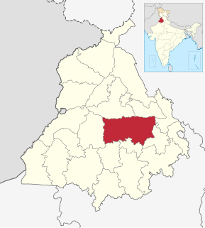
Khaira is a village in Samrala Tehsil in Ludhiana District of Punjab, India. It is located 36km to the east of District headquarters Ludhiana. 66km from State capital Chandigarh.
Khaira Pin code is 141418 and postal head office is Rampur (Ludhiana).
Khaira is surrounded by Machhiwara Tehsil to the north, Doraha Tehsil to the west, Khanna Tehsil to the south, Chamkaur Sahib Tehsil to the east.
Khanna, Morinda, Ludhiana, Nawanshahr are the nearby cities to Khaira.
This place is in the border of the Ludhiana District and Fatehgarh Sahib District. Fatehgarh Sahib District Khamano is south towards this place.
Markets
Education
Khaira nearest schools has been listed as follows.
Ludhiana District is one of the 23 districts in the Indian state of Punjab. It is Punjab's largest district by both area and population. Ludhiana, the largest city in Punjab, is the district headquarters.
Doraha is a city and a municipal council in Ludhiana district in the state of Punjab, India.
Samrala is a city and a municipal council in Ludhiana district in the Indian state of Punjab. It is about 35 km east of the district headquarters Ludhiana, on the highway to Chandigarh. Samrala is a Class III Municipality. It is also known for the oldest tehsil situated in this city. It is also believed that the name Samrala came from the name of two brothers Sama and Rala.
Ikolahi is a village in Khanna tehsil in Ludhiana district of Punjab State, India. It is located 39 km to the east of District headquarters Ludhiana. 7 km from Khanna. 68 km from State capital Chandigarh Ikolahi Pin code is 141401 and postal head office is Khanna. Libra (2 km), Bhamadi (2 km), Daudpur (2 km), Rasulra (2 km), Chakohi (3 km) are the nearby villages to Ikolahi.
Singriwala is a village in Hoshiarpur district, in Punjab, India.
Panglian is a small village in Ludhiana district in the Indian state of Punjab. It is located off of a main road going from Ludhiana to Chandigarh between Kohara and Katani. Most people of the village are farmers by trade, but now the village is being consumed by the surrounding urban development.
Apra is a census town in Phillaur Tehsil in Jalandhar district of Punjab State, India. The town is known for gold jewelry and paddy crops which are produced in large amounts. It is located 46 kilometres (29 mi) towards East from Jalandhar, 12 kilometres (7.5 mi) from Phillaur and 110 kilometres (68 mi) from Chandigarh. Apra is the largest town as compared to other surrounding villages and has the main marketplace. The town is administrated by Sarpanch an elected representative of the village.
Chak Sahbu is a small village in Jalandhar District of Punjab State, India. The village is administrated by Sarpanch who is elected representative of village. It is located 49 km towards East from Jalandhar, 14 km from Phillaur and 119 km from Chandigarh. The nearest census town and marketplace is located 1 km in Apra, Punjab. The nearest train station is situated 13.9 km away in Phillaur, nearest domestic airport is at Ludhiana and the nearest international airport is 143 km away in Amritsar.
Sowaddi Kalan or Swaddi Khas is a village in Ludhiana district in the Indian state of Punjab. Kalan is Persian language word which means Big. It is one of the most educated villages in the area. Swaddi Kalan is a large village in Jagraon of Ludhiana district with a total of 954 families and 4,804 residents in 2011.
Nagar is a village in the Phillaur tehsil of Jalandhar District of the Indian state of Punjab. It is located on Phillaur-Nawanshahr Road, 6.7 kilometres (4.2 mi) from the head postal office in Phillaur, 7 kilometres (4.3 mi) from Apra, 50 kilometres (31 mi) from Jalandhar, and 117 kilometres (73 mi) from the state capital of Chandigarh. The village is administered by the Sarpanch, an elected representative.
Khaira Mushtarka is a village in the Nakodar tehsil of Jalandhar District of the Indian state of Punjab. It is located 20 kilometres (12 mi) away from Nakodar, 44 kilometres (27 mi) from Jalandhar, and 164 kilometres (102 mi) from the state capital of Chandigarh. The village is administered by the Sarpanch, an elected representative.
Kot Garewal is a village in the Phillaur tehsil of Jalandhar District of the Indian state of Punjab. It is located 2.7 kilometres (1.7 mi) away from the postal head office Dosanjh Kalan, 12 kilometres (7.5 mi) from Phagwara, 34 kilometres (21 mi) from Jalandhar, and 124 kilometres (77 mi) from the state capital of Chandigarh. The village is administered by the Sarpanch, an elected representative.
Rurka Khurd is a large size village in Phillaur tehsil of Jalandhar District of Punjab State, India. Kalan is Persian language word which means Big and Khurd is Persian word which means small when two villages have same name then it is distinguished with Kalan means Big and Khurd means Small used with Village Name. It is located 1.6 km away from postal head office Goraya, 16.7 km from Phillaur, 35 km from district headquarter Jalandhar and 129 km from state capital Chandigarh. The village is administrated by a sarpanch who is an elected representative of village as per Panchayati raj (India). The man in the photograph is native to this village. It was his first time getting his picture taken as well. He is a cattle herder. His name is Jattmandeep Singh and has a rich knowledge of the village
Dalewal is a village in Rurka Kalan tehsil in Jalandhar district of Punjab State, India. It is located 3 km from Goraya, 30 km from district headquarter Jalandhar and 130 km from state capital Chandigarh. The village is administrated by a sarpanch who is an elected representative of village as per Panchayati raj (India).
Danduwal is a village in Rurka Kalan tehsil in Jalandhar district of Punjab State, India. It is located 2.4 km away from Rurka Kalan, 19.6 km from Phillaur, 29 km from district headquarter Jalandhar and 132 km from state capital Chandigarh. The village is administrated by a sarpanch who is an elected representative of village as per Panchayati raj (India).
Dhani Pind is a village in Rurka Kalan tehsil in Jalandhar district of Punjab State, India. It is located 8.4 km away from Rurka Kalan, 12 km from Phagwara, 22.7 km from district headquarter Jalandhar and 141 km from state capital Chandigarh. The village is administrated by a sarpanch who is an elected representative of village as per Panchayati raj (India).
Dhinpur is a village in Rurka Kalan tehsil in Jalandhar district of Punjab State, India. It is located 3 km away from Rurka Kalan, 20 km from Phillaur, 29.5 km from district headquarter Jalandhar and 132 km from state capital Chandigarh. The village is administrated by a sarpanch who is an elected representative of village as per Panchayati raj (India).
Assi Kalan is a village located in the Ludhiana East tehsil, of Ludhiana district, Punjab.
Mahadipur Kalan is a village in Shaheed Bhagat Singh Nagar district of Punjab State, India. It is located 10 kilometres (6.2 mi) away from sub post office Jadla, 18 kilometres (11 mi) from Nawanshahr, 20 kilometres (12 mi) from district headquarter Shaheed Bhagat Singh Nagar and 89 kilometres (55 mi) from state capital Chandigarh. The village is administrated by Sarpanch an elected representative of the village.
Pallian Kalan is a village in Shaheed Bhagat Singh Nagar district of Punjab State, India. It is located 1.7 kilometres (1.1 mi) away from branch post office Kot Ranjha, 11.8 kilometres (7.3 mi) from Nawanshahr, 12.7 kilometres (7.9 mi) from district headquarter Shaheed Bhagat Singh Nagar and 87 kilometres (54 mi) from state capital Chandigarh. The village is administrated by Sarpanch an elected representative of the village.
This page is based on this Wikipedia article Text is available under the CC BY-SA 4.0 license; additional terms may apply. Images, videos and audio are available under their respective licenses.