Khyber Pass Road, New Zealand

Last updated

Khyber Pass Road
The Absurd Glory Of Khyber Pass Road I.jpg
Khyber Pass Road in 2010
Khyber Pass Road, New Zealand
Length1.6 km (0.99 mi)
Location Newton, Grafton and Newmarket, New Zealand
Postal code1023
Coordinates 36°51′57″S174°46′10″E / 36.8657°S 174.7695°E / -36.8657; 174.7695
West end Symonds Street
East endBroadway

Khyber Pass Road is a street in the Auckland City Centre, New Zealand, connecting Upper Symonds Street to Broadway in Newmarket. The road is intersected by both the Western Line and the Auckland Southern Motorway.

Contents

History

A watercolour by John Kinder showing Khyber Pass Road, looking south to Ohinerau / Mount Hobson (circa 1850s) Mt Hobson and Khyber Pass from Carlton Gore Road (c. 1850s).jpg
A watercolour by John Kinder showing Khyber Pass Road, looking south to Ōhinerau / Mount Hobson (circa 1850s)
The bicycle club of the Church of the Holy Sepulchre riding on Khyber Pass Road in October 1896 Holy Sepulchre Bicycle Club (AM PH-CNEG-C22841).jpg
The bicycle club of the Church of the Holy Sepulchre riding on Khyber Pass Road in October 1896

Khyber Pass began life as a dirt track, during the early settlement of Auckland in the 1840s. [1] As the road was seen as a dangerous frontier, it was named after the Khyber Pass in modern-day Pakistan, which at the time was glamorised as the frontier of British India. [2] [3] The road, along with Great South Road, was a part of the route used by soldiers travelling south during the Invasion of the Waikato in the 1860s. [4] The spelling Kyber Pass was commonly used, up until the early 1940s. [5] [6]

The part of the road close to Newmarket was known as Hobson's Bridge, referring to an old wooden bridge that existed on modern-day Davis Crescent, which crossed Hobson's Creek, a former waterway. [7] The road was the southern border of the township of Auckland in 1852, so that an ordinance stopping loose cattle could be applied to a larger area. [8] [9]

During the late 1850s and 1860s, the land adjacent to Khyber Pass was subdivided and sold as suburban housing, including sections such as the Kyber Pass Village [10] [11] and Kyber Pass Estate. [12] [13]

The area became a centre for brewers in the mid-19th century, due to the presence of a natural spring. [4] [14] The Captain Cook Inn opened by Thomas Hancock on the road in 1859. Originally brewing beer just for the tavern, by 1862 the brewery had become a commercial venture for Hancock. [14] Richard Seccombe opened a brewery opposite the Inn in 1861 called the Great Northern Brewery, later known as Lion Brewery. [14]

In 1872, the Auckland City Council purchased land on Khyber Pass, where water reservoirs and pumping stations were established. [15]

The Captain Cook Inn was demolished in 1968. [14] The last brewery site on the road was the Lion Brewery, which sold its premises in 2008, and was later redeveloped as a satellite campus of the University of Auckland. [4] [14]

Notable locations

Related Research Articles

<span class="mw-page-title-main">Newmarket, New Zealand</span> Suburb in Auckland, New Zealand

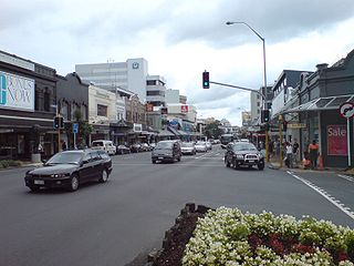
Newmarket is an Auckland suburb to the south-east of the central business district. With its high building density, especially of retail shops, it is considered New Zealand's premier retailing area, and a rival of local competitor Auckland CBD.

Captain William Cornwallis Symonds was a British Army officer who was prominent in the early colonisation of New Zealand.

<span class="mw-page-title-main">Karangahape Road</span> Road in Auckland, New Zealand

Karangahape Road is one of the main streets in the central business district (CBD) of Auckland, New Zealand. The massive expansion of motorways through the nearby inner city area – and subsequent flight of residents and retail into the suburbs from the 1960s onwards – turned it from one of Auckland's premier shopping streets into a marginal area with the reputation of a red light district. Now considered to be one of the cultural centres of Auckland, since the 1980s–1990s it has been undergoing a slow process of gentrification, and is now known for off-beat cafes and boutique shops.

<span class="mw-page-title-main">Boston Road railway station</span> Defunct railway station in New Zealand

Boston Road railway station was a station on the Western Line of the Auckland rail network, near St Peter's College and Auckland Grammar School. It was beneath an overbridge of State Highway 1, one of the busiest motorways in New Zealand. At the southern end of the station is the north western wall of Mt Eden Prison. The station closed on 10 April 2010, the day after the opening of the new Grafton station, and has since been largely demolished.

<span class="mw-page-title-main">Belmont, Auckland</span> Suburb in Auckland, New Zealand

Belmont is a suburb of Auckland, New Zealand, located on the North Shore. The suburb is in the North Shore ward, one of the thirteen administrative divisions of Auckland Council.

<span class="mw-page-title-main">Eden Terrace</span> Suburb in Auckland, New Zealand

Eden Terrace is an inner city suburb of Auckland, located 2 km south of the Auckland CBD, in the North Island of New Zealand. Eden Terrace is one of Auckland's oldest suburbs, and also one of the smallest; at just 47 hectares only Newton is smaller.

<span class="mw-page-title-main">Newton, New Zealand</span> Suburb in Auckland Council, New Zealand

Newton is a small suburb of Auckland, New Zealand, under the local governance of the Auckland Council. It had a population of 1,641 in the 2013 census.

<span class="mw-page-title-main">St Peter's College, Auckland</span> School in Auckland, New Zealand

St Peter's College is a Catholic secondary school for boys in the Edmund Rice tradition, and dedicated to St Peter. It is located in the central Auckland area of Grafton, Auckland, New Zealand. With a roll of over 1300, the school is one of the largest Catholic schools in New Zealand. St Peter's College was established in 1939 as a successor of Auckland's earliest school and of St Peter's School, founded in 1857. However, Auckland also had another Catholic secondary school dedicated to St Peter, Hato Petera College or St Peter's Māori College, which existed for 90 years from 1928 until 2018 in Northcote.

<span class="mw-page-title-main">Central Connector, Auckland</span>

The Central Connector, is a bus route between Britomart Transport Centre in the Auckland CBD, New Zealand, and the commercial suburb of Newmarket. It has some aspects of a bus rapid transit link. It was expected to improve journey times by about 14 minutes for around 2,600 buses per week, about 65,000 passengers daily. Work began in April 2008 and is now finished.

<span class="mw-page-title-main">Auckland Southern Motorway</span>

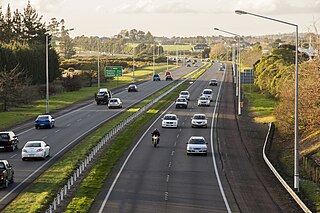
The Auckland Southern Motorway is the major route south out of the Auckland Region of New Zealand. It is part of State Highway 1.

<span class="mw-page-title-main">St Paul's Church, Auckland</span> Church in Auckland, New Zealand

St Paul's Church is an historic Anglican church, located on Symonds Street near the University of Auckland and Auckland University of Technology, in the central business district of Auckland, New Zealand. The church is the longest established parish in the city and has one of the largest Anglican congregations in Australasia.

<span class="mw-page-title-main">Grafton railway station, Auckland</span> Railway station in New Zealand

Grafton railway station is a station serving the inner-city suburb of Grafton in Auckland, New Zealand. It is located on the Western Line of Auckland's passenger rail network and consists of an island platform located in a trench near the intersection of Khyber Pass Road and Park Road. The station opened on 11 April 2010.

E. Mahoney and Son was an architectural business consisting of Edward Mahoney and his son and architectural partner, Thomas Mahoney (1855–1923), who were prominent New Zealand architects based in Auckland. They were able exponents of Gothic Revival and other styles, especially built in wood, but also in masonry and concrete. They designed numerous public (especially churches, notable examples of which are Our Lady of the Assumption Catholic Church, Onehunga, Church of St John the Baptist, Parnell, St Patrick's Cathedral, Auckland and the Church of the Holy Sepulchre, Khyber Pass Road and private buildings, many of which are still standing. They made a considerable contribution to Auckland's architectural heritage.

<span class="mw-page-title-main">Symonds Street</span> Street in Auckland, New Zealand

Symonds Street is a street in Auckland, New Zealand's most populous city. The road runs southwest and uphill from the top of Anzac Avenue, through the City Campus of University of Auckland, over the Northwestern Motorway and Auckland Southern Motorway and to the start of New North Road and Mount Eden Road.

<span class="mw-page-title-main">Symonds Street Cemetery</span> Cemetery in Auckland, New Zealand

Symonds Street Cemetery is a historic cemetery and park in central Auckland, New Zealand. It is in 5.8 hectares of deciduous forest on the western slope of Grafton Gully, by the corner of Symonds Street and Karangahape Road, and is crossed by the Grafton Bridge. The street is named for William Cornwallis Symonds, a British Army officer prominent in the early colonisation of New Zealand. It has a Historic Place – Category I listing with the New Zealand Historic Places Trust. Maintenance and administration of the cemetery is provided by the Auckland Council.

<span class="mw-page-title-main">Eden Valley, New Zealand</span> Suburb in Auckland Council, New Zealand

Eden Valley is an inner-city suburb of Auckland, the largest and most populous urban area in New Zealand. The suburb grew around Dominion Road, one of the Auckland's main arterial routes. Eden Valley's commercial hub is made up of a collection of businesses, shops, and dining options that service the area. The eclectic collection of shop fronts and signage on Dominion Road has aptly been described as, "colour and chaos". The "colour and chaos" of the commercial hub is strongly contrasted by the surrounding residential area. Eden Valley is characterized by heritage buildings that house modern day businesses, a residential area that has a range of late Victorian, Edwardian and transitional bay villas, and basalt and scoria stone walls that give the area a long established feel.

This is a timeline of the history of the city of Auckland in New Zealand.

<span class="mw-page-title-main">William Henry Skinner</span> British-NZ architect (1838–1915)

William Henry Skinner (1838–1915) was a Welsh-born architect who migrated to New Zealand.

<span class="mw-page-title-main">Church of the Holy Sepulchre, Auckland</span> Church in New Zealand

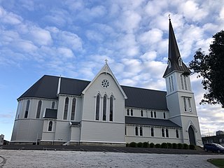
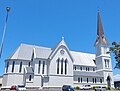
The Church of the Holy Sepulchre, commonly known as Holy Sep and St Sepulchre's, is an historic Anglican church located on Khyber Pass Road, Grafton, near the central business district of Auckland, New Zealand. The church and wider marae complex are also known as.

<span class="mw-page-title-main">George Augustus Bennett</span> English military engineer

Captain George Augustus Bennett was an English military engineer of the Corps of Royal Engineers, Board of Ordnance. He served in Corfu (1828–1832), on the Ordnance Survey of Ireland (1832–1841), as Commanding Royal Engineer in New Zealand (1842–1845) and first president of the Auckland Mechanics' Institute (1842–1845). Whilst serving in Ireland he devised and implemented the system of contours for Ordnance Survey maps. In the Colony of New Zealand he designed the flagstaff blockhouse central to the Battle of Kororāreka (1845) and other military works.

References

  1. Eliott, G. Eliot (3 December 1892). "Reminiscence of Early Days in Auckland". Evening Post. Vol. XLIV, no. 13. p. 1 (supplement) via Papers Past.
  2. Sulzberger, Jack (1991). "A Bellicose Lot". New Zealand Geographic . Retrieved 25 February 2023.
  3. McLintock, A. H., ed. (1966). "Development - Roads". An Encyclopaedia of New Zealand. Retrieved 25 February 2023.
  4. 1 2 3 Haworth, Jenny (2016). Auckland Then and Now. United Kingdom: Pavilion Books. p. 76-77. ISBN   978-1-910904-79-4. Wikidata   Q116870435.
  5. "Bant It!". Manawatu Times. Vol. 68, no. 265. 8 November 1943. p. 6 via Papers Past.
  6. "Social Notes". Waikato Times. Vol. 126, no. 21128. 1 June 1940. p. 17 (supplement) via Papers Past.
  7. "Ask Phoebe: Dedwood a stage in Ponsonby's history". The New Zealand Herald . 24 January 2011. Retrieved 25 February 2023.
  8. "Proclamation". Daily Southern Cross. Vol. IX, no. 554. 19 October 1852. p. 3 via Papers Past.
  9. "The Southern Cross. Friday, May 27, 1853". Daily Southern Cross. Vol. X, no. 617. 27 May 1853. p. 2 via Papers Past.
  10. "Kyber Pass Village, Kyber Pass Road". Daily Southern Cross. Vol. XVI, no. 1214. 22 April 1859. p. 1 via Papers Past.
  11. "Kyber Pass village, Kyber Pass Road, 49 village allotments". Auckland Libraries Heritage Collections. Retrieved 25 February 2023.
  12. "Kyber Pass Estate". The New Zealand Herald . Vol. II, no. 420. 18 March 1865. p. 2 via Papers Past.
  13. "Kyber Pass estate, comprising 120 choice building allotments". Auckland Libraries Heritage Collections. Retrieved 25 February 2023.
  14. 1 2 3 4 5 Goodall, Fiona (20 August 2009). "Brewery looks back on 140 years". Western Leader. Stuff . Retrieved 25 February 2023.
  15. "Auckland's Water Service Reservoirs". Engineering New Zealand . Retrieved 23 February 2023.
  16. "Church of the Holy Sepulchre and Hall". New Zealand Heritage List/Rārangi Kōrero. Heritage New Zealand . Retrieved 26 February 2023.
  17. Dearnaley, Mathew (9 April 2010). "Enter the station here, here, here ... or here". The New Zealand Herald . Retrieved 25 July 2010.
  18. "St David's memorial church". Ministry for Culture and Heritage. 22 October 2021. Retrieved 26 February 2023.
  19. "St David's Presbyterian Church". St David's Presbyterian Church. Archived from the original on 8 February 2021.
  20. Miller, Corazon (27 December 2023). "Central Auckland church saved from demolition reopens to public". 1 News. Retrieved 30 January 2024.
  21. O'Neill, J. C. (1968). The History of the Work of the Christian Brothers in New Zealand (Unpublished thesis – DipEd). University of Auckland. p. 102.
  22. Gibson, Anne (15 July 2016). "Auckland University thinks big with wind tunnel testing". The New Zealand Herald . Retrieved 25 February 2023.