Shortland Street, Auckland

Last updated

Shortland Street
Shortland Street Auckland.jpg
Shortland Street, Auckland
Length0.35 km (0.22 mi)
Location Auckland CBD, New Zealand
Postal code1010
West end Queen Street
East end Princes Street

Shortland Street was the initial commercial street of Auckland [1] and remains a key financial and legal centre for Auckland city. [2] It runs east from Queen Street up to Princes Street, providing a connection from the business district to the Auckland High Court and University of Auckland.

Contents

History

Shortland Street, initially called Shortland Crescent, was the initial main street of Auckland, built close to the shoreline of Commercial Bay (since reclaimed), [3] established and metalled by 1844. [4] Fore Street (now Fort Street) was built a block north on the shore of Commercial Bay in 1850. [3] The street was named for Willoughby Shortland, the first Colonial Secretary of New Zealand. [5] [6]

Shortland Street was the earliest commercial hub of Auckland. [7] [4] John Logan Campbell, David Nathan, and other early business figures in Auckland established their first stores on Shortland Street in the 1840s. The street was also ceremonially used as a way to visit Point Britomart (then a military camp), by figures such as Governor William Hobson. [5] In 1858, a major fire broke out on the street, destroying the wooden buildings in the area. [5]

By the 1860s, Queen Street had eclipsed Shortland Street as the primary commercial street for the township, after the land reclamation of Commercial Bay. [7] [4] The street was home to the Auckland Star , one of the major newspapers for Auckland in the late 19th and 20th centuries, as well as the Auckland Club, a gentlemen's club. [5]

Soap opera Shortland Street was named for the street, [5] after it was originally planned to be filmed in a TVNZ-owned studio at 74 Shortland Street.

Demographics

The statistical area of Shortland Street, which includes Fort Street and the area between Lorne Street and Kitchener Street, covers 0.13 km2 (0.050 sq mi) [8] and had an estimated population of 1,820 as of June 2022, [9] with a population density of 14,000 people per km2.

Historical population
YearPop.±% p.a.
2006816    
20131,722+11.26%
20181,602−1.43%
Source: [10]

Shortland Street had a population of 1,602 at the 2018 New Zealand census, a decrease of 120 people (−7.0%) since the 2013 census, and an increase of 786 people (96.3%) since the 2006 census. There were 1,071 households, comprising 834 males and 768 females, giving a sex ratio of 1.09 males per female. The median age was 32.1 years (compared with 37.4 years nationally), with 42 people (2.6%) aged under 15 years, 627 (39.1%) aged 15 to 29, 810 (50.6%) aged 30 to 64, and 120 (7.5%) aged 65 or older.

Ethnicities were 50.9% European/Pākehā, 3.7% Māori, 1.9% Pacific peoples, 40.4% Asian, and 8.1% other ethnicities. People may identify with more than one ethnicity.

The percentage of people born overseas was 68.7, compared with 27.1% nationally.

Although some people chose not to answer the census's question about religious affiliation, 57.5% had no religion, 24.3% were Christian, 3.4% were Hindu, 3.4% were Muslim, 3.0% were Buddhist and 2.8% had other religions.

Of those at least 15 years old, 819 (52.5%) people had a bachelor's or higher degree, and 45 (2.9%) people had no formal qualifications. The median income was $43,600, compared with $31,800 nationally. 432 people (27.7%) earned over $70,000 compared to 17.2% nationally. The employment status of those at least 15 was that 966 (61.9%) people were employed full-time, 180 (11.5%) were part-time, and 78 (5.0%) were unemployed. [10]

Notable locations

Auckland Star building c.1910 Auckland Star Newspaper Building.jpg
Auckland Star building c.1910

Related Research Articles

<span class="mw-page-title-main">Queen Street, Auckland</span> Street in Auckland, New Zealand

Queen Street is the major commercial thoroughfare in the Auckland CBD, Auckland, New Zealand's main population centre. The northern end is at Queens Wharf on the Auckland waterfront, adjacent to the Britomart Transport Centre and the Downtown Ferry Terminal. The road is close to straight, the southern end being almost three kilometres away in a south-southwesterly direction on the Karangahape Road ridge, close to the residential suburbs in the interior of the Auckland isthmus.

<span class="mw-page-title-main">Cathedral Square, Christchurch</span>

Cathedral Square, locally known simply as the Square, is the geographical centre and heart of Christchurch, New Zealand, where the city's Anglican cathedral, ChristChurch Cathedral is located. The square stands at the theoretical crossing of the city's two main orthogonal streets, Colombo Street and Worcester Street, though in practice both have been either blocked off or detoured around the square itself. The square was badly damaged in the February 2011 Christchurch earthquake.

<span class="mw-page-title-main">Sydenham, New Zealand</span> Suburb of Christchurch, New Zealand

Sydenham is an inner suburb of Christchurch, New Zealand, two kilometres south of the city centre, on and around the city's main street, Colombo Street. It is a residential, retail and light industrial suburb.
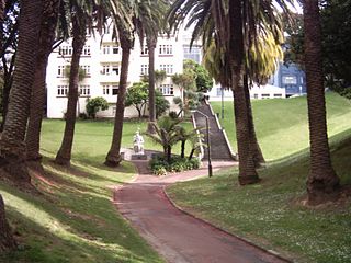
<span class="mw-page-title-main">Parnell, New Zealand</span> Suburb in Auckland, New Zealand

Parnell is a suburb of Auckland, New Zealand. It is one of New Zealand's most affluent suburbs, consistently ranked within the top three wealthiest, and is often billed as Auckland's "oldest suburb" since it dates from the earliest days of the European settlement of Auckland in 1841. It is characterised by its mix of tree-lined streets with large estates; redeveloped industrial zones with Edwardian town houses and 1920s bay villas; and its hilly topography that allows for views of the port, the Waitematā Harbour, Rangitoto Island and the Auckland Domain. To its west lies the Auckland Domain, to the south Newmarket, and to the north the Ports of Auckland.

<span class="mw-page-title-main">Cheltenham, Auckland</span> Suburb in Auckland, New Zealand

Cheltenham is a southeastern suburb of the North Shore, located in Auckland, New Zealand. It gets its name from the English town of Cheltenham, and provides a view of Rangitoto Island from its beachfront areas. The suburb is in the North Shore ward, one of the thirteen administrative divisions of Auckland Council. The area includes North Head, Cheltenham Beach, and Balmain Reserve.

<span class="mw-page-title-main">Balmoral, New Zealand</span> Suburb in Auckland, New Zealand

Balmoral is a suburb of Auckland, New Zealand that is bordered by Mount Eden, Epsom, Mount Roskill and Sandringham and is located approximately 5 km from the centre of Auckland. It was named around the turn of the 20th century and derives its name from Balmoral Castle, the Scottish country residence of the Royal family. Much of the housing in the area is from the 1920s and 1930s, often in the Californian Bungalow style. Balmoral was part of Mount Eden Borough Council which became a part of Auckland City in 1989. In November 2010, the area was included into the Albert-Eden-Roskill ward of the new Auckland Council.

<span class="mw-page-title-main">Auckland Ferry Terminal</span> Ferry building

The Auckland Ferry Terminal, also called the Downtown Ferry Terminal, is the hub of the Auckland ferry network, which connects the Auckland CBD with suburbs in North Shore, West Auckland, and South Auckland, and islands in the Hauraki Gulf. The terminal is on the Auckland waterfront, at the north end of Queen Street, across Quay Street from the Britomart Transport Centre, which is the hub for local buses and trains.

<span class="mw-page-title-main">Dilworth Building</span> Mixed-use in Corner of Customs Street and Queen Street

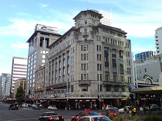
The Dilworth Building is a heritage mixed-use building at the corner of Customs Street and Queen Street in the Auckland CBD, New Zealand. The building by William Gummer & Reginald Ford was constructed between 1925 and 1927, and is listed as a "Historic Place - Category I" by Heritage New Zealand.

<span class="mw-page-title-main">Archibald Clark (politician)</span> New Zealand politician

Archibald Clark was a Scottish 19th-century Member of Parliament in the Auckland Region, New Zealand. He was the first Mayor of Auckland in 1851. His company, Archibald Clark and Sons, manufactured clothing and was a wholesaler.

<span class="mw-page-title-main">Colombo Street</span> Main road in Christchurch, New Zealand

Colombo Street is a main road of the city of Christchurch, New Zealand. It runs south-north through the centre of Christchurch with a break at Cathedral Square. As with many other central Christchurch streets, it is named for a colonial Anglican bishopric, Colombo, Sri Lanka in what at the time was known as Ceylon. Parts of the street which run through Sydenham were known as Addison Street during the 1880s, and some parts were known as Colombo Road.

<span class="mw-page-title-main">Imperial Hotel, Auckland</span> Hotel building in Auckland, New Zealand

The former Imperial Hotel is located at the corner of Fort and Queen Street in Auckland, New Zealand. It was built in 1883 and is now a notable example of Victorian architecture. The building was registered as a category II heritage structure by the New Zealand Historic Places Trust in 1987. The building's current use is as a backpackers hostel, pub, and communal lounge.

<span class="mw-page-title-main">Governors Bay</span> Place in Canterbury, New Zealand

Governors Bay is a small town in Canterbury, New Zealand.

<span class="mw-page-title-main">Symonds Street</span> Street in Auckland, New Zealand

Symonds Street is a street in Auckland, New Zealand's most populous city. The road runs southwest and uphill from the top of Anzac Avenue, through the City Campus of University of Auckland, over the Northwestern Motorway and Auckland Southern Motorway and to the start of New North Road and Mount Eden Road.

<span class="mw-page-title-main">Cecil Wood (architect)</span> New Zealand architect (1878–1947)

Cecil Walter Wood was a New Zealand architect. He was the dominant architect in Canterbury during the interwar period.

<span class="mw-page-title-main">Kenneth Myers Centre</span> Historic building in New Zealand

The Kenneth Myers Centre is a landmark building in Auckland, New Zealand. Originally known as the 1YA Building and then the Television New Zealand building, the building was purchased by the University of Auckland and modified in 2000–01. Located in Shortland Street in the Auckland CBD, the "strikingly original structure" built in 1934 is registered by Heritage New Zealand as a Category I building. The Gus Fisher Gallery is located in the building.

<span class="mw-page-title-main">Tauranga Central</span> Central Business District of Tauranga, New Zealand

Tauranga Central is a suburb and the central business district of Tauranga, in the Bay of Plenty Region of New Zealand's North Island.

<span class="mw-page-title-main">Hobson Street, Auckland</span>

Hobson Street is the major street in Auckland, New Zealand. It lies on the western side of Queen Street. It is a commercial and high-rise residential street, and provides access to the Auckland Northern Motorway going south, and the Northwest Motorway going west. For most of its length it is one-way. One block to the west is Nelson Street, which is one-way in the other direction and provides access to the central city for traffic exiting from the motorways. One block to the east is Albert Street, part of Mayoral Drive, and Vincent Street. The area encompassed by these streets is called Hobson Ridge by Statistics New Zealand.

Quay Street is the northernmost street in the Auckland CBD, New Zealand. The Auckland Ferry Terminal, which has ferries running to Devonport, Waiheke Island, and other places in Waitematā Harbour; the Hilton Auckland hotel; and Ports of Auckland are on the north side of the street. The Britomart Transport Centre, Queen Elizabeth Square and Grand Mercure Auckland hotel are on the south side.

<span class="mw-page-title-main">Anzac Avenue, Auckland</span>

Anzac Avenue is a street in Auckland, New Zealand's most populous city. It was constructed between 1914 and 1919 to link Beach Road to Symonds Street, and was named as a memorial to the troops who died in the Gallipoli campaign.

The Strand is a street in Auckland, New Zealand's most populous city. It connects the Ports of Auckland to the Auckland motorway network, and is the eastern end of State Highway 16.

References

  1. McClure, Margaret (5 August 2016). "Auckland places—Auckland central business district". Te Ara: The Encyclopedia of New Zealand .
  2. "Land Yourself on Shortland". Bayleys. Retrieved 20 July 2020.
  3. 1 2 "Auckland's Original Shoreline Heritage Walk Brochure" (PDF). Auckland City. Retrieved 20 July 2020.
  4. 1 2 3 "The Early Days of Auckland". Heart of the City Auckland. Retrieved 20 July 2020.
  5. 1 2 3 4 5 Haworth, Jenny (2016). Auckland Then and Now. United Kingdom: Pavilion Books. p. 16-17. ISBN   978-1-910904-79-4. Wikidata   Q116870435.
  6. Bush, G. W. A. (1971). Decently and in Order: The Centennial History of the Auckland City Council. Collins. p. 26.
  7. 1 2 Campbell, Dr Nerida; Truttman, Lisa; Auckland City Council; Ngāti Pāoa; Ngāti Whātua-o-Ōrākei. "Auckland's Original Shoreline" (PDF). Auckland Council . Retrieved 24 September 2021.
  8. "ArcGIS Web Application". statsnz.maps.arcgis.com. Retrieved 12 July 2022.
  9. "Population estimate tables - NZ.Stat". Statistics New Zealand . Retrieved 25 October 2022.
  10. 1 2 "Statistical area 1 dataset for 2018 Census". Statistics New Zealand. March 2020. Shortland Street (133700). 2018 Census place summary: Shortland Street
  11. "Blackett's Building". New Zealand Heritage List/Rārangi Kōrero. Heritage New Zealand . Retrieved 20 July 2020.
  12. "South British Insurance Building (Former)". New Zealand Heritage List/Rārangi Kōrero. Heritage New Zealand . Retrieved 20 July 2020.
  13. "Jean Batten Place Departmental Building (Former)". New Zealand Heritage List/Rārangi Kōrero. Heritage New Zealand . Retrieved 20 July 2020.
  14. "Hotel DeBrett". New Zealand Heritage List/Rārangi Kōrero. Heritage New Zealand . Retrieved 20 July 2020.
  15. LaHatte, Deborah (9 May 2013). "Orphan Auckland CBD sites on the block". National Business Review.
  16. "General Buildings (including Yorkshire House)". New Zealand Heritage List/Rārangi Kōrero. Heritage New Zealand . Retrieved 20 July 2020.
  17. Mace, William (24 September 2010). "All change for the Auckland Club". Stuff.
  18. "Vero Centre". The Scyscraper Center. Retrieved 20 July 2020.
  19. "1YA Radio Station Building (Former)". New Zealand Heritage List/Rārangi Kōrero. Heritage New Zealand . Retrieved 20 July 2020.
  20. "Shortland Flats". New Zealand Heritage List/Rārangi Kōrero. Heritage New Zealand . Retrieved 20 July 2020.
  21. "Churton Memorial". New Zealand Heritage List/Rārangi Kōrero. Heritage New Zealand . Retrieved 20 July 2020.

36°50′47″S174°46′00″E / 36.8465°S 174.7668°E / -36.8465; 174.7668