
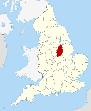
Nottinghamshire is a ceremonial county in the East Midlands of England. The county borders South Yorkshire to the north-west, Lincolnshire to the east, Leicestershire to the south, and Derbyshire to the west. The largest settlement is the city of Nottingham (323,632).

Gedling is a local government district with borough status in Nottinghamshire, England. The council is based in Arnold. The borough also includes Carlton along with villages and rural areas to the north-east of Nottingham. The main built-up part of the borough around Arnold and Carlton forms part of the Nottingham Urban Area.
Arnold is a market town in the Borough of Gedling in the county of Nottinghamshire in the East Midlands of England. It is situated to the north-east of Nottingham's city boundary. Arnold has the largest town centre in the Borough of Gedling and the most important town centre in the northeastern part of the conurbation of Greater Nottingham. Gedling Borough Council is headquartered in Arnold. Since 1968 Arnold has had a market, and the town used to have numerous factories associated with the hosiery industry. Nottinghamshire Police have been headquartered in Arnold since 1979. At the time of the 2011 United Kingdom census, Arnold had a population of 37,768.

Carlton is a town in the Borough of Gedling, Nottinghamshire, England. It is to the east of Nottingham. The population at the 2011 Census was 6,881. It was an urban district until 1974, whose wards had an estimated population of 48,416 in 2015. Owing to the growth of residential, commercial and industrial in the wider Gedling Borough, City of Nottingham, Borough of Broxtowe, Rushcliffe and Ashfield District, as well as the Amber Valley and Borough of Erewash in Derbyshire which have become quite urban around Nottingham, Carlton and Gedling, as well as Netherfield form a contiguous urban area.
Redhill is a small community forming part of the much larger town of Arnold in Nottinghamshire, England. It is approximately 4 miles (6.4 km) north of the city of Nottingham in the borough of Gedling. The area is home to approximately 2,000 people, many of whom are commuters. The population is shown in the Gedling ward of Bonington.

Nottingham East is a constituency represented in the House of Commons of the UK Parliament since 2019 by Nadia Whittome of the Labour Party.
Gedling is a constituency in Nottinghamshire created in 1983 represented in the House of Commons of the UK Parliament since 2019 by Tom Randall of the Conservative Party. The seat was a safely Conservative until the Labour Party's landslide victory in 1997, when it was won for Labour by Vernon Coaker. Labour held Gedling until 2019, when it was regained by the Conservative Party.
Sherwood is a large district and ward of the city of Nottingham, England, 1.5 miles (2.4 km) north of the city centre. The population at the 2011 census was 15,414. It is bordered by Woodthorpe to the northeast, Mapperley to the east, Carrington to the south, New Basford and Basford to the west, and Daybrook and Bestwood to the north.
Colwick is a village, civil parish, in the Borough of Gedling in Nottinghamshire, England. It is situated to the east of Nottingham's city boundary, and forms the Colwick ward. At the time of the 2011 census, the village had a population of 2,829.
Nottinghamshire Police is the territorial police force responsible for policing the shire county of Nottinghamshire and the unitary authority of Nottingham in the East Midlands area of England. The area has a population of just over 1 million.

Gedling is a village and former civil parish which gives its name to the larger Borough of Gedling in Nottinghamshire, England. It lies 4 miles (6.4 km) north-east of Nottingham city centre. The parish was abolished in 1935 and absorbed into the urban district of Carlton, which in turn was abolished in 1974 on the creation of borough of Gedling. The population of the Gedling ward at the 2011 census was 6,817 and 111,787 for the district. Gedling was recorded in the Domesday Book and is still a distinct settlement, although residential, commercial and industrial growth in the wider borough of Gedling and the neighbouring city of Nottingham, boroughs of Broxtowe and Rushcliffe and district of Ashfield means it can be difficult to distinguish the village of Gedling from the nearby town of Carlton, with which it has become contiguous.

Netherfield is a town in the Borough of Gedling in Nottinghamshire, England. It is situated to the east of Nottingham's city boundary and is approximately 3 miles (4.8 km) between Colwick and Carlton in the NG4 postcode area, and near the River Trent. The appropriate Gedling ward was called 'Netherfield and Colwick' until boundary reorganisation in 2015, when it became 'Netherfield', with 'Colwick' becoming a separate ward.. At the time of the 2011 census, the population of this ward was 7,398.

Nottingham City Transport (NCT) is the major bus operator of the city of Nottingham, England. NCT operates extensively within Nottingham as well beyond the city boundaries into Nottinghamshire county. Publicly-owned, it is today the second largest municipal bus company in the United Kingdom after Lothian Buses in Edinburgh, Scotland.

Mapperley is a residential and commercial area of north-eastern Nottingham, England. The area is bounded by Sherwood to the north-west, Thorneywood to the south and Gedling to the east.

Woodthorpe is part of the Borough of Gedling in Nottinghamshire, England, next to the Nottingham city boundary and the areas of Mapperley, Daybrook, Sherwood and Arnold.
The Nottinghamshire Football Association, often known simply as the Notts FA, is the governing body of football in the county of Nottinghamshire, England. The Nottinghamshire FA runs a number of cups at different levels for teams across most of Nottinghamshire, as well as educating their affiliated clubs and members with relevant courses and events. A small number of clubs in the north of the county are members of the Sheffield and Hallamshire County Football Association.

Daybrook is a suburb of Arnold, Nottinghamshire. The area is located just outside the city of Nottingham but inside the conurbation of Greater Nottingham. It lies next to the areas of Arnold town centre, Sherwood, Woodthorpe, Redhill and Bestwood.
The Battle of Mapperley Hills was an incident on Tuesday 23 August 1842, which marked the culmination of several days of Chartist disturbances in the Nottingham area. Troops and police broke up an assembly of about five thousand people and arrested four hundred when they refused to disperse. The site of the assembly and "the battle" may have been in Mapperley Hills Common, close to where Ransom Road meets Woodborough Road. The Common, of 54 acres, and the adjoining Coppice of the Hunger Hills were open to the inhabitants of Nottingham, but owned by Nottingham Corporation as lord of the manor.


