King's Inch

Last updated

King's Inch
King's Inch and the Pudzeoch Basin, Renfrew Ferry, Renfrewshire.jpg
King's Inch and the Ferry Village from the Renfrew Ferry
Location
Renfrewshire UK relief location map.jpg
Red pog.svg
King's Inch
Location in Renfrewshire
Scotland relief location map.jpg
Red pog.svg
King's Inch
Location in Scotland
OS grid reference NS513674
Coordinates 55°52′34″N4°22′41″W / 55.876°N 4.378°W / 55.876; -4.378
Physical geography
Island groupIslands of the River Clyde
Administration
Sovereign state United Kingdom
Country Scotland
Council area Renfrewshire
Demographics
Population0
Lymphad3.svg

King's Inch and the much smaller Sand Inch were islands lying in the estuarine waters of the River Clyde close to Renfrew in Renfrewshire, Scotland. Due to dredging and a change of the course of the main current of the River Clyde, silting, etc. it has become part of the southern, Renfrewshire side, of the river bank and is now built over.

Contents

Also recorded as 'The King's Inch' or simply 'Inch.' Walter fitz Alan built a second stone castle on a motte on the mainland in Renfrew itself and this became the principal messuage or manor place of the barony, the powerbase of the Fitz Alan's who were to become the Stewart line of monarchs. [1] Both names relate to the Royal lands here held by King Robert II and later Stewart monarchs.

The name lives on in a street name, etc. and King's Inch railway station once served Renfrew from 1903 to 1926 on the Glasgow and Renfrew District Railway.

Islands in the River Clyde

View up the Clyde from Newshot Island. Newshot Island from the nature reserve, River Clyde.jpg
View up the Clyde from Newshot Island.

Islands of the River Clyde, rather than sand or mud banks only exposed at low water, once included in order, working upstream towards Glasgow :- Milton, Bodinbo, Newshot, Ron, Sand Inch, Kings Inch, Buck Inch, White Inch and Water Inch. A Colin's Isle once sat in the waters of the Cart near its confluence with the River Clyde. [2]

The name 'Inch' is Scots deriving from the Gaelic 'Innis', an island. [3] The name 'Ron' in Scots refers to a thicket of hawthorns or rose briers, an area of stunted and crowded woodland. [4] Buck Inch may translate as a place where the sound of pouring or gushing water was heard. [5]

Sand Inch

This was a small island lying downstream of the King's Inch. It remained as an island on Timothy Pont's map of the late 16th century. [6] The later mid 17th century map by Robert Gordon does not record the island. [7] No island is shown in 1745 on Herman Molls map. [8] Sand Inch has been incorporated into the river bank of the Clyde and into King's Inch. The island may have joined with King's Inch by the mid 17th century.

King's Inch

The Renfrew Ferry looking towards Yoker. Renfrew Ferry. View across to Yoker. River Clyde.jpg
The Renfrew Ferry looking towards Yoker.

King's Inch was a sizeable island off the river bank of the Clyde at Renfrew in the then Barony of Renfrew. It ceased to be an island at some point after the mid eighteenth century. [9] It may have joined with the islet of Sand Inch before it joined with the mainland and also joined with the islet of Buck Inch at some point that lay nearby upstream.

Originally the Renfrew Ferry service operated from King's Inch, 12 mile (800 m) further upstream on land which is now the site of the Braehead Shopping Centre at the Marlin Ford's location, but a move was agreed in 1778 to better serve the town of Renfrew and to prevent public access to the Elderslie Estate as the path ran through their land, with the Spier's family completing in 1791 the building the Ferry Road, the ferry house, quays and slipways, etc. [10]

Castles

Walter fitz Alan (born c.1110; died 1177), as High Steward of Scotland in the reign of David I (1124-1153), constructed the first castle here in the 12th century. It was probably mainly a wooden fortification with stone foundations on an earth motte surrounded by a flooded moat. [11]

From this base Walter eventually established a power base which acted act as a buffer to protect David I's interests in this part of his kingdom. Somerled of the Isles and Fergus of Galloway had made an alliance in the reign of Malcolm IV and it was the Renfrew lands which were threatened with Somerled, King of the Isles, arriving in 1164 with 160 ships in the Firth of Clyde. The invasion fleet failed, and in battle somewhere near Renfrew, Somerled was killed. [12]

The Castle at King's Inch was abandoned in the 13th century and replaced by a stone castle in what is now the centre of Renfrew. [11]

In the latter half of the 15th century, Sir John Ross (died. c. 1474) was granted the 'Lands of Inch' with the ruins of this first castle and built Inch Castle, a three-storeyed stone fortification on the site of the old castle. In 1732 the last member of this Ross family died here. [11] The castle was a small, 'L' shaped tower house with a stair turret in the re-entrant angle. [12] It had been demolished by 1791. James IV made Sir John Ross the hereditary constable of the original castle. [10]

King's Inch and Paisley Abbey

Paisley Abbey from near Blackhall. Paisley Abbey from Saucelhill Park, Renfrewshire.jpg
Paisley Abbey from near Blackhall.

Thirteen monks from Much Wenlock arrived at Renfrew c. 1168 and were lodged at the Steward's castle on King's Inch at a church dedicated to Saints Mary and James. The accommodation at Paisley Abbey was not ready for them at the time. Osbert was appointed as the prior. The monks had fishing rights on the River Clyde. By the year 1172 the monks had moved to Paisley Abbey. Walter gave King's Inch and all the fishings on the Clyde between the island and Partick to the abbey. [13]

The island was granted to Paisley Abbey and remained abbey property until 1208–1213, at which time the priory of Paisley excambied the island to Walter, the grandson of the first Steward in exchange for lands elsewhere. After the initial purpose of the castle was superseded and the monks were in residence it is likely to have been abandoned during this period. [12] [14]

Sir John Ross of Hawkhead

A story is recorded of how Sir John came to acquire King's Inch through a man to man contest at the Kempe Knowe near the Knock, how to the Knox family, near Paisley - "The King of England, it is said, challenged Scotland to furnish a man able to fight a famous champion then in attendance on the English Court. The King of Scotland accepted the challenge, but was for some time unable to find a man equal to the task, and in his perplexity offered the Inch as a reward to any one who successfully encountered the Englishman. At last Sir John Ross of Hawkhead offered himself, and arrangements were made for the fight on the Knowe. The moat was filled with water, and a large fire kindled upon the mound. Neither party was expected to give quarter. To escape was to meet death by drowning, and to be vanquished was to perish, if not otherwise, by fire. The Englishman was of large stature; Ross was small but remarkably agile and of great strength. He dressed himself in a tight-fitting skin with the smooth side outwards, and in order to make it more slippery, rubbed it well with grease or oil. The Englishman was unable to get a grip of him, and at last held out his hands, inviting Ross to grasp them. The invitation was "palm my arm." This, it is said, is exactly what Ross wanted. He seized the Englishman by the wrists, and by a sudden jerk, wrenched his arms out of their sockets, and then made and end of him."

The King tried to go back on his pledge and offered Sir John land elsewhere, however the champion offered to serve his sovereign at another time and he would make do with the Inch and its castle for now. He became known far and wide as "Palm-my-arm." [15]

Elderslie House

The old Renfrew Ferry basin Basin at the Renfrew Ferry - geograph.org.uk - 938046.jpg
The old Renfrew Ferry basin

Mr Andrew Speirs of Elderslie (1714-1782), a Virginia merchant and Glasgow tobacco lord, purchased the lands in 1760 which together with other lands in Ayrshire became the Barony of Elderslie by Crown Charter in 1767. [16]

Speirs is said to have demolished Inch Castle and constructed another castle, which he then had demolished only a few years later. [11] It seems more likely that Speirs repaired Inch Castle before building Elderslie House in 1777 a little to the north and he incorporated some of the stone from the 15th century castle. [17] It was designed by Robert Adam and was four storeys high with a pavilion roof and faced north. [18] The lake, tree and shrub planting, etc. had been completed by 1782 and Andrew died shirtly after. [18] The 1856 OS map marks the site of the old castle lying to the south-west of the mansion house. [19]

In 1775 a small mansion house is marked with the Pudzeoch Burn running to the Clyde nearby to the north. [20] The 1800 John Ainslie [21] and the 1826 John Thomson's map shows a substantial ornamental lake that was stocked with ornamental fish, [18] lying to the south-east of the mansion house, partly on the line of the old river course, [22] that is absent by 1859.

By 1859 the name King's Inch is still shown at the Elderslie Estate and its boundary from the Pudzeoch Burn at the Renfrew Ferry and upstream the Marlin Ford on the River Clyde delineate the lands of the old King's Inch. The Glasgow and Inchinan boundary line follows the same course at this point with the Braehead Estate on the Glasgow side. [23]

Elderslie House (NS 5140 6762) was in turn demolished in 1924 after the death of the last occupant, William Peacock, a manufacturer of rope and cord in Paisley. [18]

Braehead Power Station and Braehead Shopping Centre

After demolition the Elderslie Estates Company sold the site and in 1951 Braehead Power Station opened at a cost of £5 million as one of the first post-war power stations. In the early 1980s it had become time expired and was demolished. Housing schemes and the Braehead shopping and leisure complex were built on the old island's site. [11] [18] Nothing now remains of the castles or estate.

The Course of the River Clyde

James Watt's 1736 survey of the River Clyde. James Watt's survey of the River Clyde.jpg
James Watt's 1736 survey of the River Clyde.

The Clyde flooded in the 17th century and its course altered. The 'First Statistical Account' states that the river "left its usual course, nearly opposite to Scotstoun, took a semi-circular direction, leaving the King’s Inch on the north side, and running along the bottom of the garden belonging to the manse, came into its present direction". This shows that up to that time the River Clyde's main current flowed to the south of the Kings Inch, directly in front of the mainland Renfrew Castle, partly the line of the Pudzeoch Burn. [12] The extensive dredging operations in the River Clyde in the 18th and 19th centuries resulted in the island finally becoming joined to the mainland. [16]

Timothy Pont's map of the late 16th century shows the island with roughly equal width channels of the River Clyde either side. It is shown to be larger than the 3-hectare (7.4-acre) Newshot Island and a substantial castle is marked. [6] The later mid 17th century map by Robert Gordon shows the same channel width and a castle of other significant building. [7]

In 1745 Herman Moll's map shows the island with a minor channel on the south side and no buildings appear to be present. [8] In the mid 18th century no buildings are indicated on William Roy's map however a minor channel still divides the island from the south bank. Ross's 1773 map marks Inch Castle and a short distance to the north-east an Inch House is recorded, indicating that the two co-existed for a time. [24]

See also

Related Research Articles

Renfrewshire Council area of Scotland

Renfrewshire is one of the 32 council areas of Scotland.

Braehead Shopping mall in Renfrewshire, Scotland

Braehead is a commercial development located at the former site of Braehead Power Station in Renfrew on the south bank of the River Clyde in Renfrew, Renfrewshire. It is particularly notable for its large shopping centre, arena and leisure facilities.

Linwood, Renfrewshire Human settlement in Scotland

Linwood is a small town in Renfrewshire in the west central Lowlands of Scotland, 14 miles west of Glasgow. It is about 1+12 miles northeast of Johnstone and west of Paisley close to the Black Cart Water and the A737 road.

Ralston, Renfrewshire Human settlement in Scotland

Ralston is a small, suburban settlement in Renfrewshire, Scotland, being part of the greater town of Paisley. The district straddles the A761, the main dual-carriageway between Renfrewshire and the City of Glasgow.

Erskine Post town in Renfrewshire, Scotland

Erskine is a town in the council area of Renfrewshire, and historic county of the same name, situated in the West Central Lowlands of Scotland. It lies on the southern bank of the River Clyde, providing the lowest crossing to the north bank of the river at the Erskine Bridge, connecting the town to Old Kilpatrick in West Dunbartonshire. Erskine is a commuter town at the western extent of the Greater Glasgow conurbation, bordering Bishopton to the west and Renfrew, Inchinnan, Paisley and Glasgow Airport to the south. Originally a small village settlement, the town has expanded since the 1960s as the site of development as an overspill town, boosting the population to over 15,000. In 2014, it was rated one of the most attractive postcode areas to live in Scotland.

Shieldhall Human settlement in Scotland

Shieldhall is a district in the Scottish city of Glasgow. It is situated directly south of the River Clyde and is part of the wider Govan area.

Renfrewshire (historic) Historic county and lieutenancy area of western Scotland

Renfrewshire or the County of Renfrew is a historic county, registration county and lieutenancy area in the west central Lowlands of Scotland. It contains the local government council areas of Inverclyde, Renfrewshire and East Renfrewshire, as well as parts of Glasgow and is occasionally named Greater Renfrewshire to distinguish the county from the modern council area.

Renfrew Ferry

The Renfrew Ferry is a passenger ferry service linking the north and south banks of the River Clyde in Scotland. The service, operated by Clydelink without subsidy, crosses between Renfrew and Yoker, close to Glasgow City Centre and is the last Clyde crossing this far upstream.

The Glasgow and Renfrew District Railway was nominally owned by the Glasgow and Paisley Joint Railway. It was incorporated on 6 August 1897 and opened on 1 June 1903.

Caldwell, East Renfrewshire

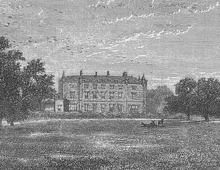
Caldwell is a mansion and old estate with the remains of a castle nearby. These lands lie close to the Lugton Water and the villages of Uplawmoor in East Renfrewshire and Lugton in East Ayrshire.

Renfrew Castle Castle in Renfrewshire, Scotland, UK

Renfrew Castle was situated at the royal burgh of Renfrew, Scotland, which is near the confluence of the River Clyde and the River Cart. The original 12th-century castle was built by Walter fitz Alan, Steward of Scotland, upon a river islet known as the King's Inch. This was replaced in the 13th century with a new castle by the road to the Clyde ferry, which became a royal castle under King Robert II. In the 15th century, the King's Inch site was rebuilt as Inch Castle by Sir John Ross. Both castles were demolished in the 18th century and nothing remains above ground at either site.

Renfrew Human settlement in Scotland

Renfrew is a town 6 miles (10 km) west of Glasgow in the west central Lowlands of Scotland. It is the historic county town of Renfrewshire. Called the "Cradle of the Royal Stewarts" for its early link with Scotland's former royal house, Renfrew gained royal burgh status in 1397.

Auchenbathie Tower

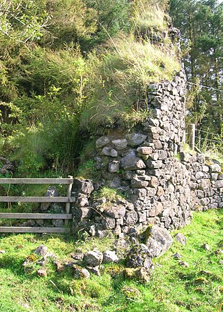
Auchenbathie, Auchinbathie Tower or rarely Barcraigs Tower is a ruined fortification, a tower house, once held by the Wallace Clan of Elderslie, situated in Renfrewshire, Parish of Lochwinnoch, Scotland. The spelling used varies greatly and "Auchenbathie" will be used here as the standard spelling. The pronunciation locally is "Auchenbothy", the same as a Victorian mansion in Kilmacolm; no connection is known.

Lands of Elliston

The lands of Elliston, previously Elliotston or Eliotstoun or Elliestoun in the Parish of Lochwinnoch were part of the holdings of the Barony of Elliston, later a part of the Castle Semple barony and estates. The ruins of the castle lie a short distance from Howwood in Renfrewshire in a private garden on a minor road between the A737 and the B776. The name may have derived from earlier holders of the lands, however the Sempill family held them since at least 1220. The castle was abandoned circa 1550 when John Sempill, 1st Lord Sempill moved to a new castle at Castleton which he renamed Castle Semple.

Duchal Castle

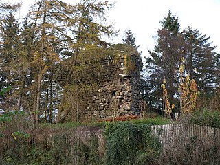
The ruins of the large courtyard style Duchal Castle lie circa 1.5 miles west of Kilmacolm in the Inverclyde council area and the historic county of Renfrewshire in the west central Lowlands of Scotland. The castle stands at the bottom of the valley of the River Gryfe on a peninsula created by the Blacketty and Green Waters which have their confluence beyond the two deep gorges.

Bodinbo Island

Bodinbo Island is an islet in the estuarine waters of the River Clyde close to the old ferry slipway at Erskine. Before the dyke or training wall was built the rocky Bodinbo Island was a prominent feature in the river hereabouts and a hazard to shipping, especially sailing craft in the dark, during foggy weather, flood conditions and in high winds. On Ordnance Survey maps the name has been transliterated to Bottombow Island and Boden Boo is the spelling variant used for the nearby woodland plantation.

Park Quay

The disused Park Quay or Fulton's Quay is located on the old Lands of Park, situated on the south bank of the River Clyde in the Parish of Inchinnan, close to Newshot Island and the old Rashielee Quay. A slipway is also part of the infrastructure, giving access to the dock at low tide, both once served by roads running through the Park Estate from the south. It was recorded as Fulton's Quay in 1830, the name of a previous owner of the Park Estate who may have built it prior to 1801. A fixed light was installed at Park Quay in 1869.

Rashielee Quay Port in Scotland

The old Rashielee Quay or Rashielie Quay (NS471709) was located on the old Lands of North Barr, situated on the south bank of the River Clyde in the Parish of Inchinnan, between Bodinbo Island and Park Quay. It was built to facilitate the loading of boats and barges with whinstone excavated from the nearby Rashielee Quarries that was brought to the quay by a horse drawn wagonway.

Newshot Island

Newshot Island or Newshot Isle was an island of circa 50 acres or 20 hectares lying in the estuarine waters of the River Clyde close to Park Quay in the Parish of Inchinnan, Renfrewshire, Scotland. Due to silting, etc. it has become part of the southern, Renfrewshire side, of the river bank and is used for grazing cattle and as a nature reserve.

White Inch Small river island near Glasgow, Scotland

White Inch was an island lying in the estuarine waters of the River Clyde close to Glasgow in the Parish of Govan, Lanarkshire, Scotland. Due to the deliberate disposal of dredged material from the Clyde, it became physically part of the northern, Lanarkshire side, of the river bank from the 1830s and is now entirely built over. The name lives on in the Whiteinch district of Glasgow, street names, etc., and probably relates to white colored sand deposits.

References

Notes
  1. Leighton, John (1840). Strath-Clutha or the Beauties of Clyde. Joseph Swan. p. 143.
  2. "Gazetteer of Scotland - Parish of Inchinnan" . Retrieved 22 July 2018.
  3. "Timothy Pont's map No.33" . Retrieved 24 July 2018.
  4. "Dictionary of Scots" . Retrieved 24 July 2018.
  5. "Dictionary of Scots" . Retrieved 8 March 2020.
  6. 1 2 "Pont, Timothy (1560?-1614?). Title:[Renfrewshire] - Pont 33. Imprint: [ca. 1583-96]" . Retrieved 8 March 2020.
  7. 1 2 "Gordon, Robert, 1580-1661. Barony of Ranfrew. [ca. 1636-52]" . Retrieved 8 March 2020.
  8. 1 2 "Moll, Herman, (d.1732) The Shire of Renfrew with Cuningham. The North Part of Air [i.e. Ayr]. London : Bowles and Bowles, 1745" . Retrieved 8 March 2020.
  9. "1747-55 - William ROY - Military Survey of Scotland" . Retrieved 8 March 2020.
  10. 1 2 Sweeney, Dan (2015). Postscript to the Past. Windan Press. p. 88. ISBN   9780992714840.
  11. 1 2 3 4 5 "Canmore - King's Inch" . Retrieved 8 March 2020.
  12. 1 2 3 4 "The Castle Guy" . Retrieved 8 March 2020.
  13. Metcalfe, William (1905). A History of the County of Renfrew. Alexander Gardner. p. 30.
  14. Metcalfe, William (1905). A History of the County of Renfrew. Alexander Gardner. p. 31.
  15. Metcalfe, William (1905). A History of the County of Renfrew. Alexander Gardner. p. 409.
  16. 1 2 Sweeney, Dan (2015). Postscript to the Past. Windan Press. p. 92. ISBN   9780992714840.
  17. "Canmore - Elderslie House" . Retrieved 8 March 2020.
  18. 1 2 3 4 5 Sweeney, Dan (2015). Postscript to the Past. Windan Press. p. 93. ISBN   9780992714840.
  19. "Renfrewshire VIII.11 (Renfrew) Survey date:1856 Publication date:1859" . Retrieved 8 March 2020.
  20. "Taylor, George (1760-1788) Skinner, Andrew (1760-1788). The road from Edinr, to Glasgow & Greenock & to Dunbarton & Inveraray. [London : s.n.]. 1775" . Retrieved 8 March 2020.
  21. "Ainslie, John, 1745-1828" . Retrieved 8 March 2020.
  22. "John Thomson's Atlas of Scotland, 1832" . Retrieved 8 March 2020.
  23. "Dumbartonshire, Sheet XXVIII (Inset XXIX), Surveyed: 1859, Published: 1864" . Retrieved 8 March 2020.
  24. "Ross, Charles, 1722-1806. A map of the shire of Lanark. 1773" . Retrieved 9 March 2020.
Sources