Clay County is a county in the U.S. state of West Virginia. As of the 2020 census, the population was 8,051. Its county seat is Clay. The county was founded in 1858 and named in honor of Henry Clay, famous American statesman, member of the United States Senate from Kentucky and United States Secretary of State in the 19th century.
Hanover County is a county in the Commonwealth of Virginia. As of the 2020 census, the population was 109,979. Its county seat is Hanover Courthouse.

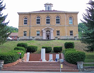
Clay is a town in and the county seat of Clay County, West Virginia, United States. The population was 399 at the 2020 census. It is the only incorporated town in Clay County.

Blacksville is an Incorporated Town in Monongalia County, West Virginia, United States. The population was 118 at the 2020 census. It is included in the Morgantown, West Virginia Metropolitan Statistical Area.

West Virginia's 3rd congressional district is an obsolete U.S. congressional district in southern West Virginia. At various times the district covered different parts of the state, but in its final form included the state's second-largest city, Huntington; included Bluefield, Princeton, and Beckley; and has a long history of coal mining, forestry, and farming.
Independence is an unincorporated community on Independence Mountain in Clay County, West Virginia, United States. It is located along West Virginia Route 16.
Little Italy is an unincorporated community in Clay County, West Virginia, United States. It lies at an elevation of 787 feet (240 m).
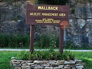
Wallback Wildlife Management Area is located on 11,758 acres (4,758 ha) northwest of Clay in Clay, Kanawha and Roane Counties, West Virginia.

The 2000 United States presidential election in West Virginia took place on November 7, 2000 as part of the 2000 United States presidential election. Voters chose 5 representatives, or electors to the Electoral College, who voted for president and vice president.
Harrison is an unincorporated community in Clay County, West Virginia, United States. Harrison is 8 miles (13 km) northeast of Clay.
Duck is an unincorporated community along the border of Braxton and Clay counties in West Virginia, United States. Duck is 11.5 miles (18.5 km) northeast of Clay. Duck has a post office with ZIP code 25063.
Big Otter is an unincorporated community in Clay County, West Virginia, United States. Big Otter is located on Big Otter Creek at the junction of Interstate 79 and West Virginia Route 16. The community is 9.5 miles (15.3 km) north-northeast of Clay, the county seat of Clay County. Big Otter is part of ZIP code 25113. Its original post office with a zip code of 25020 closed in 1979.
Procious is an unincorporated community in Clay County, West Virginia, United States. Procious is located on the Elk River and West Virginia Route 4, 7 miles (11 km) west-northwest of Clay. Procious has a post office with ZIP code 25164.
Nebo is an unincorporated community in Clay County, West Virginia, United States. Nebo is located on West Virginia Route 16, 12 miles (19 km) north-northeast of Clay, along the Stinson Creek near its source. Nebo no longer has a post office, which came under the aegis of ZIP code 25141.

This is a list of the National Register of Historic Places listings in Clay County, West Virginia.

The 1996 United States presidential election in West Virginia took place on November 5, 1996, as part of the 1996 United States presidential election. Voters chose five representatives, or electors to the Electoral College, who voted for president and vice president.
Triplett is an unincorporated community in Clay County, West Virginia, United States.

West Virginia's 12th Senate district is one of 17 districts in the West Virginia Senate. It is currently represented by Republicans Ben Queen and Patrick Martin. All districts in the West Virginia Senate elect two members to staggered four-year terms.


