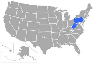
West Virginia is a state in the Southern United States. It is bordered by Pennsylvania to the north and east, Maryland to the east and northeast, Virginia to the southeast, Kentucky to the southwest, and Ohio to the northwest. West Virginia is the 10th-smallest state by area and ranks as the 12th-least populous state, with a population of 1,793,716 residents. The capital and largest city is Charleston which has a population of 49,055.

The West Virginia Intercollegiate Athletic Conference (WVIAC) was a collegiate athletic conference which historically operated exclusively in the state of West Virginia, but briefly had one Kentucky member in its early years, and expanded into Pennsylvania in its final years. It participated in the Division II ranks of the National Collegiate Athletic Association (NCAA), originally affiliated in the National Association of Intercollegiate Athletics (NAIA) until 1994, but held its final athletic competitions in spring 2013, and officially disbanded on September 1 of that year. Its football-playing members announced in June 2012 that they planned to withdraw to form a new Division II conference at the end of the 2012–13 season; this led to a chain of conference moves that saw all but one of the WVIAC's members find new conference homes.

The Appalachian Mountains, often called the Appalachians, are a system of mountains in eastern to northeastern North America. The Appalachians first formed roughly 480 million years ago during the Ordovician Period. They once reached elevations similar to those of the Alps and the Rocky Mountains before experiencing natural erosion. The Appalachian chain is a barrier to east–west travel, as it forms a series of alternating ridgelines and valleys oriented in opposition to most highways and railroads running east–west.

McDowell County is a county in the U.S. state of West Virginia. As of the 2020 census, the population was 19,111. Its county seat is Welch. McDowell County is the southernmost county in the state. It was created in 1858 by the Virginia General Assembly and named for Virginia Governor James McDowell. It became a part of West Virginia in 1863, when several Union-affiliated counties seceded from the state of Virginia during the American Civil War. McDowell County is located in the Cumberland Mountains, part of the Appalachia region.

Bluefield is a city in Mercer County, West Virginia, United States. The population was 9,658 at the 2020 census. It is the principal city of the Bluefield micropolitan area extending into Virginia, which had a population of 106,363 in 2020.

Beckley is a city in and the county seat of Raleigh County, West Virginia, United States. The population was 17,286 at the 2020 census, making it the ninth-largest city in the state. It is the principal city of the Beckley metropolitan area of Southern West Virginia, home to 115,079 residents in 2020. Beckley was founded on April 4, 1838, and was long known for its ties to the coal mining industry. It is the home of the West Virginia University Institute of Technology, as well as campuses of Concord University and the University of Charleston.

Appalachia is a cultural region located in the central and southern sections of the Appalachian Mountains of the Eastern United States. It stretches from the western Catskill Mountains in the east end of the Southern Tier of New York State west and south into Pennsylvania, continuing on through the Blue Ridge Mountains into northern Georgia, and through the Great Smoky Mountains from North Carolina into Tennessee and northern Alabama. In 2020, the region was home to an estimated 26.1 million people, of whom roughly 80% are white.

The Blue Ridge Mountains are a physiographic province of the larger Appalachian Mountains range. The mountain range is located in the Eastern United States, and extends 550 miles southwest from southern Pennsylvania through Maryland, West Virginia, Virginia, North Carolina, South Carolina, Tennessee, and Georgia. This province consists of northern and southern physiographic regions, which divide near the Roanoke River gap. To the west of the Blue Ridge, between it and the bulk of the Appalachians, lies the Great Appalachian Valley, bordered on the west by the Ridge and Valley province of the Appalachian range.

The Allegheny Mountain Range, informally the Alleghenies, is part of the vast Appalachian Mountain Range of the Eastern United States and Canada and posed a significant barrier to land travel in less developed eras. The Allegheny Mountains have a northeast–southwest orientation, running for about 400 miles (640 km) from north-central Pennsylvania, southward through western Maryland and eastern West Virginia.

"Take Me Home, Country Roads", also known simply as "Country Roads", is a song written by Bill Danoff, Taffy Nivert and John Denver. It was released as a single performed by Denver on April 12, 1971, peaking at number two on Billboard's US Hot 100 singles for the week ending August 28, 1971. The song was a success on its initial release and was certified Gold by the RIAA on August 18, 1971, and Platinum on April 10, 2017. The song became one of John Denver's most popular songs. It has continued to sell, with over 1.6 million digital copies sold in the United States.

Collegiate summer baseball leagues are amateur baseball leagues in the United States and Canada featuring players who have attended at least one year of college and have at least one year of athletic eligibility remaining. Generally, they operate from early June to early August. In contrast to college baseball, which allow aluminum or other composite baseball bats, players in these leagues use only wooden bats, hence the common nickname of these leagues as "wood-bat leagues". Collegiate summer leagues allow college baseball players the ability to compete using professional rules and equipment, giving them experience and allowing professional scouts the opportunity to observe players under such conditions.

Cheat Mountain is an exceptionally high and rugged ridge situated in the Allegheny Mountains of eastern West Virginia, USA. It is about 50 miles (80 km) long and more than five miles (8 km) wide at its widest. Its highest point is at its southernmost end at Thorny Flat, which has an elevation of 4,848 feet (1,478 m). Several other knobs rise above 4,000 feet (1,200 m) along its length.

The Battle of Blair Mountain was the largest labor uprising in United States history and the largest armed uprising since the American Civil War. The conflict occurred in Logan County, West Virginia, as part of the Coal Wars, a series of early-20th-century labor disputes in Appalachia. Up to 100 people were killed, and many more arrested.

Canaan Valley Resort State Park is a state park in the eastern United States, within Canaan Valley in Tucker County, West Virginia. Located in the highest valley east of the Mississippi River, the park contains the second-largest inland wetland area in the United States. The valley featured the first commercial ski development in West Virginia.
Ice Mountain is a mountain ridge and algific talus slope that is part of a 149-acre (60 ha) preserve near the community of North River Mills in Hampshire County, West Virginia, United States. It was designated a National Natural Landmark in 2012.
Droop Mountain is a small mountain in the Allegheny Mountains on the border of Greenbrier and Pocahontas counties in southeastern West Virginia. It was the scene of one of West Virginia's most important battles during the American Civil War—the Battle of Droop Mountain.
Mountain Lake Wilderness is a U.S. Wilderness Area in the George Washington and Jefferson National Forests. The wilderness area is located next to privately owned Mountain Lake, and consists of 8,314 acres (3,365 ha) in Virginia and 2,721 acres (1,101 ha) in West Virginia.
Sharon is an unincorporated community and coal town in southeastern Kanawha County, West Virginia, United States, located along the West Virginia Turnpike.

Droop is an unincorporated community in Pocahontas County, West Virginia, United States, in the Greenbrier River Valley.
Coco is an unincorporated community in Kanawha County, West Virginia, United States.


