Kingsley, Western Australia

Last updated

Kingsley
Perth,  Western Australia
Whitfords station from Whitfords Ave.jpg
Whitfords railway station, Kingsley
Kingsley, Western Australia
Coordinates 31°48′29″S115°47′38″E / 31.808°S 115.794°E / -31.808; 115.794 Coordinates: 31°48′29″S115°47′38″E / 31.808°S 115.794°E / -31.808; 115.794
Population13,204 (SAL 2021) [1]
Established1977
Postcode(s) 6026
Area7.5 km2 (2.9 sq mi)
Location20 km (12 mi) from Perth
LGA(s) City of Joondalup
State electorate(s) Kingsley
Federal division(s) Moore Cowan
Suburbs around Kingsley:
Craigie Woodvale Wangara
Padbury Kingsley Madeley
Duncraig Greenwood Marangaroo

Kingsley is a suburb of Perth, Western Australia, located within the City of Joondalup. Kingsley is bounded to the north by Whitfords Avenue, to the south by Hepburn Avenue, to the west by the Mitchell Freeway and to the east by Wanneroo Road.

Contents

Lake Goollelal lies in the eastern part of the suburb, parallel to Wanneroo Road. The Kingsley residential area is thus divided by the lake, with a small enclave between the lake and Wanneroo Road.

History

The suburb of Kingsley is named after the village of Kingsley which is near Winchester in Hampshire, England. The name was chosen for the historical association with the first owner of land in the area, William Kernot Shenton. Shenton was born in Winchester in 1802, and arrived in Western Australia in 1829. [2] The suburb name was approved in 1974. [3] In 1844 Methodist missionary Rev John Smithes established Mission Farm near Lake Goollelal. It was to be a farm to be worked and occupied by aboriginal people under the guidance of the church. [4] Businessman Ezio Luisini purchased 20 acres (8.1 hectares) of land near Lake Goollelal on which he established a winery in 1924. It was once one of the largest wineries in the southern hemisphere [5] and operated from 1929 until 1986 when it was closed and the land redeveloped into suburban lots by Ernie Mondello. [6]

Sport

Kingsley is the home of Kingsley Football club, which includes a Junior club. The Kingsley Football club had a number of members killed in the 2002 Bali bombings, a memorial was held at Kingsley Oval. The Kingsley-Woodvale Junior and Senior Cricket Clubs can also be found here. Kingsley has a tennis club, which was originally based in Kingsley, however it relocated to the neighbouring suburb of Woodvale in 1987 due to a lack of courts. Kingsley also have a soccer (football) team named Kingsley Soccer Club that are based in Woodvale at Chichester Park on Trappers Drive. The club became incorporated in 1990 and is celebrating their 25th anniversary in 2015. They currently have five teams competing in the Football West competitions. They have teams based at the highest level of the Sunday league competing in the Sunday premier league first team and reserve competitions. They also have a third men's team competing in the division one metropolitan league after advancing from the division three metropolitan league over the past three years. The club also has a women's team and a vets team competing in the Bankwest women's metropolitan league and Mysolar masters league.

Education

There are five primary schools located within Kingsley;

Religion

There are four churches in Kingsley:

Shopping

There are two major shopping centres located in Kingsley:

Attractions

Accommodation

Transport

Transperth operates bus routes 445, 446, 447 through Kingsley running in both directions between Warwick and Whitfords railway stations. Additionally routes 355, 374, 376 and 465–468 buses travel along Kingsley's northern boundary, Whitfords Avenue, whilst routes 450 and 389 along Wanneroo Road services the small residential strip east of Lake Goollelal. train stations are located at both the south western (Greenwood) and north western (Whitfords) corners of Kingsley.

Related Research Articles

Balga is a suburb of Perth, the capital city of Western Australia, 13 kilometres (8 mi) north of Perth city's central business district (CBD). Its local government area is the City of Stirling. Mark Irwin is the current mayor.

<span class="mw-page-title-main">Currambine, Western Australia</span> Suburb of Perth, Western Australia

Currambine is a northern suburb of Perth, the capital city of Western Australia, 29 km north of Perth's central business district. Its local government area is the City of Joondalup. It contains the Currambine Central shopping centre and cinema complex.

<span class="mw-page-title-main">Greenwood, Western Australia</span> Suburb of Perth, Western Australia

Greenwood is a suburb of Perth, Western Australia, located in the City of Joondalup. The suburb is located 18 km from Perth's central business district. It is bordered by the Mitchell Freeway, Hepburn ave, Wanneroo road and Warwick road.

<span class="mw-page-title-main">Joondalup</span> Suburb of Perth, Western Australia

Joondalup is a suburb of Perth, Western Australia, approximately 26 kilometres (16 mi) north of Perth's central business district. It contains the central business district of the regional City of Joondalup and acts as the primary urban centre of Perth's outer northern suburbs.

Carramar is a suburb of Perth, Western Australia, located within the City of Wanneroo and it is situated 30 km from the Perth CBD. Its postcode is 6031, and it came into being, together with Tapping to the south, in 1995 as a subdivision of Neerabup.

<span class="mw-page-title-main">Clarkson, Western Australia</span> Suburb of Perth, Western Australia

Clarkson is an outer northern suburb of Perth, Western Australia, located 34 kilometres north of Perth's central business district in the City of Wanneroo.

<span class="mw-page-title-main">Girrawheen, Western Australia</span> Suburb of Perth, Western Australia

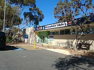
Girrawheen is a northern suburb of Perth, the capital city of Western Australia. Its local government area is the City of Wanneroo.

Landsdale is a northern suburb of Perth, Western Australia located within the local government area of the City of Wanneroo. It is mixed use, with residential, commercial and light manufacturing areas.

<span class="mw-page-title-main">Madeley, Western Australia</span> Suburb of Perth, Western Australia

Madeley is a suburb of Perth, the capital city of Western Australia 20 kilometres (12 mi) north of Perth's central business district. Its local government area is the City of Wanneroo. Previously part of Landsdale, much of the suburb was rural in character until the 1990s, with market gardening a common activity. From 2001 onwards, extensive property development resulted in massive population growth, with the Property Investor Magazine of December 2007 estimating a growth rate of 33.3% per year.

Tapping is a suburb of Perth, Western Australia, located within the City of Wanneroo. It came into being in the early 1990s as a subdivision of Wanneroo, originally as part of the Carramar estate.

<span class="mw-page-title-main">Merriwa, Western Australia</span> Suburb of Perth, Western Australia

Merriwa is a coastal, northern suburb of Perth, Western Australia, 36 kilometres (22 mi) north of the central business district. It is part of the City of Wanneroo local government area. It is a predominantly residential suburb, containing two RAAF retirement villages.

Heathridge is a suburb of Perth, Western Australia, located 33 kilometres (21 mi) south of Yanchep within the City of Joondalup.

<span class="mw-page-title-main">Woodvale, Western Australia</span> Suburb of Perth, Western Australia

Woodvale is a suburb of Perth, Western Australia, located within the City of Joondalup and the City of Wanneroo. At the 2016 census Woodvale had a population of 9,276.

<span class="mw-page-title-main">Wanneroo Road</span> Road in Perth, Western Australia

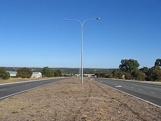
Wanneroo Road is a 44-kilometre (27 mi) arterial highway in the northern suburbs of Perth, Western Australia linking Joondanna and Yokine in the south with Wanneroo and Yanchep in the north. As part of State Route 60, it begins from Charles Street in the inner city and becomes Indian Ocean Drive up to Dongara.

<span class="mw-page-title-main">City of Joondalup</span> Local government area in Western Australia

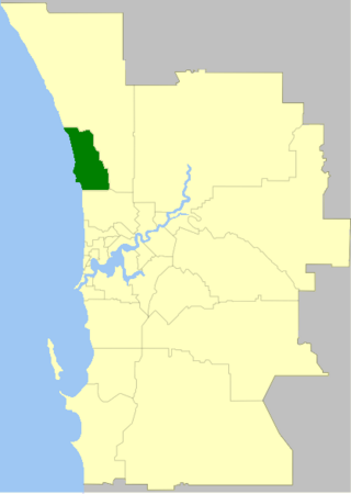
The City of Joondalup is a local government area in Perth, Western Australia. Its central business district is located in the suburb Joondalup, and it includes the town centres of Hillarys and Warwick.

<span class="mw-page-title-main">Hepburn Avenue</span> Road in Perth, Western Australia

Hepburn Avenue is an arterial east-west road in the northern suburbs of Perth, Western Australia. The road links Sorrento in the west with Malaga and Whiteman in the east. It also connects the residential developments that span its length with several local facilities, as well as major road routes into central Perth.

<span class="mw-page-title-main">Whitfords Avenue</span> Road in Perth, Western Australia

Whitfords Avenue is an arterial east–west road located in the northern suburbs of Perth, Western Australia.

<span class="mw-page-title-main">Ocean Reef Road</span> Road in Perth, Western Australia

Ocean Reef Road is an arterial east-west road in Perth, Western Australia. It is located within the northern suburbs of Perth, from Ocean Reef in the west, to Landsdale in the east, with a portion travelling northwards along the coast to Iluka.

<span class="mw-page-title-main">Yellagonga Regional Park</span> Regional park in Perth, Western Australia

Yellagonga Regional Park is in Perth, Western Australia, in the City of Wanneroo and the City of Joondalup. The park was established in 1989 by the Western Australian government and protects 1,400 hectares of land, including 550 hectares of Wanneroo wetlands – including Lake Joondalup, Beenup Swamp, Walluburnup Swamp and Lake Goollelal.

Woodvale Secondary College, formerly Woodvale Senior High School, is an independent public co-educational partially academically-selective high day school, located in Woodvale, a suburb 20 kilometres (12 mi) north of Perth, Western Australia. Opened in 1985, the school's catchment area covers parts of the City of Joondalup and the adjacent eastern portion of the City of Wanneroo. The school has an enrolment of 1,409 students from Year 7 to Year 12.

References

  1. Australian Bureau of Statistics (28 June 2022). "Kingsley (Suburb and Locality)". Australian Census 2021 QuickStats. Retrieved 28 June 2022.  OOjs UI icon edit-ltr-progressive.svg
  2. Western Australian Genealogical Society website, Retrieved 2010-03-23
  3. "History of metropolitan suburb names – K". Western Australian Land Information Authority. Retrieved 23 March 2010.
  4. City of Wanneroo website Archived 26 January 2010 at the Wayback Machine , Retrieved 2010-03-23
  5. Friends of Yellagonga Regional Park website Archived 4 March 2012 at the Wayback Machine , Retrieved 2012-01-12
  6. Heritage Council of Western Australia: Register of Heritage Places – Assessment Documentation 16 March 2001, Retrieved 2010-06-20