
The IndusIN-dəs is a transboundary river of Asia and a trans-Himalayan river of South and Central Asia. The 3,120 km (1,940 mi) river rises in mountain springs northeast of Mount Kailash in Western Tibet, flows northwest through the disputed region of Kashmir, bends sharply to the left after the Nanga Parbat massif, and flows south-by-southwest through Pakistan, before emptying into the Arabian Sea near the port city of Karachi.

The Geography of Pakistan is a profound blend of landscapes varying from plains to deserts, forests, and plateaus ranging from the coastal areas of the Indian Ocean in the south to the mountains of the Karakoram, Hindukush, Himalayas ranges in the north. Pakistan geologically overlaps both with the Indian and the Eurasian tectonic plates where its Sindh and Punjab provinces lie on the north-western corner of the Indian plate while Balochistan and most of the Khyber Pakhtunkhwa lie within the Eurasian plate which mainly comprises the Iranian Plateau.
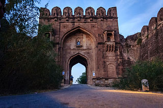
Jhelum District, is partially in Pothohar Plateau, and partially in Punjab Plain of the Punjab province of Pakistan. Jhelum is one of the oldest districts of Punjab. It was established on 23 March 1849. According to the 1998 census, the district had a population of 936,957, of which 31.48% were urban. Jhelum District has a diverse population of 1,103,000 (2006). Jhelum is known for providing many soldiers to the British and later to the Pakistan armed forces due to which it is also known as 'city of soldiers' or 'land of martyrs and warriors'. The district of Jhelum stretches from the river Jhelum almost to the Indus. Salt is quarried at the Mayo mine in the Salt Range. There are two coal mines in the district from which the North-Western railway obtains parts of its supply. These are the only coal mines in Punjab province which are in working condition. The chief center of the salt trade is Pind Dadan Khan. The district is crossed by the main line of the North-Western railway and also traversed along the south by a branch line. It is located in the north of the Punjab province, Jhelum district is bordered by Sargodha and Mandi Bahauddin to its south, Khushab to its southwest, Jhelum River to its south and east, Gujrat to its east, Chakwal to its west, Mirpur to its northeast, and Rawalpindi to its north.

The Ravi River is a transboundary river crossing northwestern India and eastern Pakistan. It is one of five rivers associated with the Punjab region.

Doab is a term used in South Asia for the tract of land lying between two confluent rivers. It is similar to an interfluve. In the Oxford Hindi-English Dictionary, R. S. McGregor defines it as from Persian do-āb "a region lying between and reaching to the confluence of two rivers.

The Jhelum River (/dʒʰeːləm/) is a river in the northern Indian subcontinent. It originates at Verinag and flows through the Indian-administered territory of Jammu and Kashmir, into Pakistani-administered Azad Kashmir, then the Pakistani province of Punjab. It is the westernmost of the five rivers of the Punjab region, and flows through the Kashmir Valley. It is a tributary of the Chenab River and has a total length of about 725 kilometres (450 mi).

The Chenab River is a major river that flows in India and Pakistan, and is one of the 5 major rivers of the Punjab region. It is formed by the union of two headwaters, Chandra and Bhaga, which rise in the upper Himalayas in the Lahaul region of Himachal Pradesh, India. The Chenab flows through the Jammu region of Jammu and Kashmir, India into the plains of Punjab, Pakistan, before ultimately flowing into the Indus River.

Jhang is the capital city of Jhang District, in the central portion of the province of Punjab, Pakistan. Situated on the east bank of the Chenab river, it is among the 18th largest city of Pakistan by population.
Jhang District is a district of Faisalabad division in the Punjab province, Pakistan. Jhang city is the capital of district.

Sheikhan town is situated in Chiniot Tehsil and in District Chiniot in Punjab province of Pakistan.
The Sandal Bar is a region between the rivers Chenab and Ravi in Punjab, Pakistan.

Shorkot, , is a city in Punjab, Pakistan.
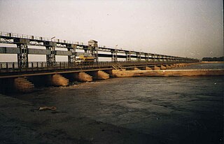
Trimmu Barrage is a barrage on the River Chenab in the Jhang District of the Punjab province of Pakistan. It is situated downstream of the confluence of the River Jhelum and River Chenab. It is situated some 25 km from the city of Jhang near the city of Atharan Hazari where the River Jhelum flows into the River Chenab. It was one of the 7 link canals to be built under the Indus Water Plan of Pakistan. Pakistan created this plan after Indus Water Treaty
Barana is a union council of Lalian tehsil in Chiniot District, Punjab province, Pakistan.

The Thal desert is situated at 31°10’ N and 71°30’ E in the province of Punjab, Pakistan. Located near the Pothohar Plateau, the area falls under the Indomalayan biogeographic realm and stretches for a length of approximately 190 miles (310 km) with a maximum breadth of 70 miles (119 km).m.m.m.s It is bound by the piedmont of the northern Salt Range, the Indus River flood plains in the west and the Jhelum and Chenab River floodplains in the east. It is a subtropical sandy desert that resembles the deserts of Cholistan and Thar geographically.
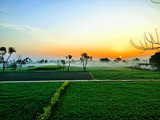
The Bar Region, or the Bars, is an area in central Punjab, now part of the Punjab Province of Pakistan. The area consists of agricultural land that was cleared in the nineteenth century for the then 'new' canal irrigation system that the British were developing at the time. The soil of the Bar Region is fertile. The plains of fertile land have been created by the stream deposits driven by the many rivers flowing from the Himalayas.
Athara Hazari, is a city and capital of 18-Hazari Tehsil situated on the Jhang-Bakhar Highway within the boundaries of the Jhang District, Punjab, Pakistan.

The topography of Pakistan is divided into seven geographic areas: the northern highlands, the Indus River plain, the desert areas, the Pothohar Plateau, Balochistan Plateau, Salt Range, and the Sistan Basin. All the rivers of Pakistan, i.e. Sindh, Ravi River, Chenab River, Jhelum River, and Sutlej River, originate from the Himalayas mountain range. Some geographers designate Plateau as to the west of the imaginary southwest line; and the Indus Plain lies to the east of that line.
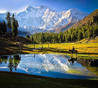
The Western Himalayas refers to the western half of the Himalayas, in northern Pakistan and northwestern India. It is also known as the Punjab Himalayas. Four of the five tributaries of the Indus River in Punjab rise in the Western Himalayas; while the fifth, the Sutlej cuts through the range after rising in Tibet.


