
Pike County is located in the U.S. state of Alabama. As of the 2020 census the population was 33,009. Its county seat is Troy. Its name is in honor of General Zebulon Pike, of New Jersey, an explorer who led an expedition to southern Colorado and discovered Pikes Peak in 1806.
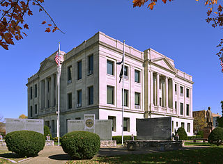
Pike County is a county on the eastern border of the U.S. state of Missouri, bounded by the Mississippi River. As of the 2020 census, the population was 17,587. Its county seat is Bowling Green. Its namesake was a city in middle Kentucky, a region from where many early migrants came. The county was organized December 14, 1818, and named for explorer Zebulon Pike. The folksong "Sweet Betsy from Pike" is generally thought to be associated with Pike County, Missouri.

Pike County is a county located on the southwestern border of the U.S. state of Mississippi. As of the 2020 census, the population was 40,324. The county seat is Magnolia. Pike County is named for explorer Zebulon Pike. Pike County is part of the McComb, MS Micropolitan Statistical Area.

Lincoln County is a county located in the U.S. state of Mississippi. As of the 2020 census, the population was 34,907. Its county seat is Brookhaven.

Itawamba County is a county located in the U.S. state of Mississippi. As of the 2020 United States Census, the population was 23,863. Its county seat is Fulton. The county is part of the Tupelo, MS Micropolitan Statistical Area.
Pike County is a county in the U.S. state of Illinois. It is located between the Mississippi River and the Illinois River in western Illinois. According to the 2020 United States Census, it had a population of 14,739. Its county seat is Pittsfield.

Kirkville is a city in Wapello County, Iowa, United States. The population was 157 at the time of the 2020 census.

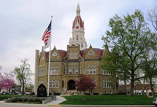
Magnolia is a city in Pike County, Mississippi and the county seat. The population was 2,420 at the 2010 census. Magnolia is within the McComb, Mississippi Micropolitan Statistical Area.

McComb is a city in Pike County, Mississippi, United States. The city is approximately 80 miles (130 km) south of Jackson. As of the 2010 census, the city had a total population of 12,790. It is the principal city of the McComb, Mississippi Micropolitan Statistical Area.

Osyka is a town in Pike County, Mississippi, United States. It is located on the Mississippi–Louisiana state line. The population was 440 at the 2010 census. It is part of the McComb, Mississippi Micropolitan Statistical Area. The peak of its population was in 1910.
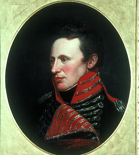
Zebulon Montgomery Pike was an American brigadier general and explorer for whom Pikes Peak in Colorado was named. As a U.S. Army officer he led two expeditions under authority of President Thomas Jefferson through the Louisiana Purchase territory, first in 1805–1806 to reconnoiter the upper northern reaches of the Mississippi River, and then in 1806–1807 to explore the southwest to the fringes of the northern Spanish-colonial settlements of New Mexico and Texas. Pike's expeditions coincided with other Jeffersonian expeditions, including the Lewis and Clark Expedition and the Red River Expedition in 1806.

Wall Doxey State Park is a public recreation area located off Mississippi Highway 7, seven miles (11 km) south of Holly Springs, Mississippi. The state park is centered on 60-acre (24 ha) Spring Lake.

The McComb Micropolitan Statistical Area is a micropolitan area in southwestern Mississippi that includes Amite, and Pike Counties, which had a combined population of 53,124 as of the 2020 census.
Mississippi's 7th congressional district existed from 1883 to 1953. It was created after the 1880 census and abolished following the 1950 census.

The 2004 United States presidential election in Mississippi took place on November 2, 2004 as part of the 2004 United States presidential election. Voters chose six representatives, or electors to the Electoral College, who voted for president and vice president. It was the first presidential election since the 2000 United States census, after which Mississippi lost one electoral vote, reducing its elector count from seven to six, leaving Mississippi with the fewest electoral votes since 1848.
Kirkville is a census-designated place and unincorporated community in Itawamba County, Mississippi, United States.
Munger is an unincorporated community in Pike County, Illinois, United States. The location is adjacent to the Pike-Adams county line on the Mississippi floodplain two miles east of the Mississippi River and northeast of East Hannibal. Fall Creek is approximately 1.5 miles to the northeast. The Burlington Northern Railroad line passes by the community.
Kirkville is an unincorporated community in Tangipahoa Parish, Louisiana, United States. The community is located 1 mile S of Osyka, Mississippi and 18 miles N of Amite City, Louisiana


