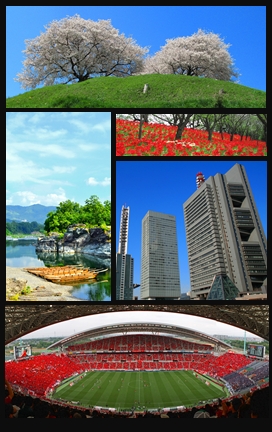
Saitama Prefecture is a landlocked prefecture of Japan located in the Kantō region of Honshu. Saitama Prefecture has a population of 7,338,536 and has a geographic area of 3,797 km2. Saitama Prefecture borders Tochigi Prefecture and Gunma Prefecture to the north, Nagano Prefecture to the west, Yamanashi Prefecture to the southwest, Tokyo to the south, Chiba Prefecture to the southeast, and Ibaraki Prefecture to the northeast.

The Capital District, also known as the Capital Region and the endonym Capitaland, is the metropolitan area surrounding Albany, the capital of the U.S. state of New York. The Capital District was first settled by the Dutch in the early 17th century and came under English control in 1664. Albany has been the permanent capital of the state of New York since 1797. The Capital District is notable for many historical events that predate the independence of the United States, including the Albany Plan of Union and the Battles of Saratoga.
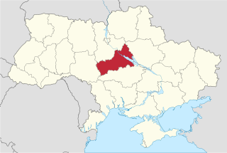
Cherkasy Oblast, also referred to as Cherkashchyna is an oblast (province) in central Ukraine located along the Dnieper River. The administrative center of the oblast is the city of Cherkasy. The current population of the oblast is 1,160,744.

Delta State is a state in the South-South geopolitical zone of Nigeria. Named after the Niger Delta—a large part of which is in the state—the state was formed from the former Bendel State on August 27, 1991. Bordered on the north by Edo State, the east by Anambra and Rivers States, and the south by Bayelsa State across the Niger River for 17 km and the Forçados River for 198 km, while to the west is the Bight of Benin which covers about 160 kilometres of the state's coastline. The State was initially created with 12 local government areas in 1991 which was later extended to 19 and now has 25 local government areas. Asaba as its state capital is located along the River Niger on the northeastern end of the State, while the state's economic centre is the twin cities of Warri and Uvwie

Mtwara Region is one of Tanzania's 31 administrative regions. The regional capital is the municipality of Mtwara. Mtwara Region is home to one of the most infuluencial people in Tanzania, the Makonde. Mtwara is home to Tanzania's 4th president Benjamin Mkapa and is home to a number of influential artists. The boundary with Mozambique to the south is formed by the Ruvuma River. To the west, Mtwara is bordered by Ruvuma Region, to the north by Lindi Region, and to the east is the Indian Ocean.

The Florida Parishes, on the east side of the Mississippi River—an area also known as the Northshore or Northlake region—are eight parishes in the southeastern portion of the U.S. state of Louisiana.
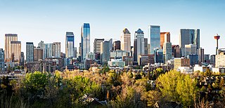
The Calgary Metropolitan Region (CMR), also commonly referred to as the Calgary Region, is a conglomeration of municipalities centred on Calgary, the largest city in Alberta.

Bilecik Province is a province in midwest Turkey, neighboring Bursa to the west, Kocaeli and Sakarya to the north, Bolu to the east, Eskişehir to the southeast and Kütahya to the south, spanning an area of 4,307 km2. The population is 228,334. Most of the province laid down in Marmara Region but eastern parts of Gölpazarı and Söğüt district and districts of İnhisar and Yenipazar remained in Black Sea Region, smaller southeastern parts of Bozüyük and Söğüt remained in Central Anatolia Region and smaller southwestern part of Bozüyük remained in Aegean Region.

Tovuz District is one of the 66 districts of Azerbaijan. It is located in the north-west of the country and belongs to the Gazakh-Tovuz Economic Region. The district borders the districts of Gadabay, Shamkir, Samukh, Agstafa, as well as the Tavush Province of Armenia and Kakheti region of Georgia. Its capital and largest city is Tovuz. As of 2020, the district had a population of 177,200. A major train line runs through the center, stopping at Tovuz Station.
Southwestern Ontario is a secondary region of Southern Ontario in the Canadian province of Ontario. It occupies most of the Ontario Peninsula bounded by Lake Huron, including Georgian Bay, to the north and northwest; the St. Clair River, Lake St. Clair, and Detroit River, to the west; and Lake Erie to the south. To the east, on land, Southwestern Ontario is bounded by Central Ontario and the Golden Horseshoe. The region had a population of 2,583,544 in 2016. It is sometimes further divided into "Midwestern Ontario" covering the eastern half of the area and the heart of Southwestern Ontario encompassing the western half of the region.

Lindi Region is one of Tanzania's 31 administrative regions. The region covers an area of 66,040 km2 (25,500 sq mi). The region is comparable in size to the combined land area of the nation state of Sri Lanka. The regional capital is the municipality of Lindi.

Bardere is a district in the southwestern Gedo region in Jubaland State of Somalia. It is the second largest and most populous city in Jubaland with Kismayo being the largest and most densely populated city in the region. Bardera sits on the Jubba River around 250 km west of the city of Baidoa and is in a highland area with fertile soil. The city experiences extremely hot temperatures from December to April and heavy rainfalls from April to May knowns as Gu (spring) The city was formerly known as the "Onion capital of the World" for its production of the vegetable, the name Bardere means tall palm trees. The palms were cut to construct native homes or midille.

Lysychansk, is a city in Sievierodonetsk Raion, Luhansk Oblast, eastern Ukraine. It is located on the high right bank of the Donets River, approximately 115 kilometres (71 mi) from the administrative center of the oblast, Luhansk. It faces Sievierodonetsk across the river. Its population before the Russian invasion of Ukraine was approximately 93,340.

Grand Bay-Westfield is a town in New Brunswick on the west bank of the Saint John River immediately north of the boundary between Kings County and Saint John County.

Aleppo Governorate is one of the fourteen governorates of Syria. It is the most populous governorate in Syria with a population of more than 4,867,000, almost 23% of the total population of Syria. The governorate is the fifth in area with an area of 18,482 km2 (7,136 sq mi), or 18,498 sq. km, about 10% of the total area of Syria. The capital is the city of Aleppo.

Kyzylorda Region is a region of Kazakhstan. Its capital is the city of Kyzylorda, with a population of 234 736. The region itself has a population of 823 251. Other notable settlements include Aral, Kazaly (Kazalinsk) and the Russian-administered Baikonur, which services the Baikonur Cosmodrome. The total area of the province is 226,000 square kilometers (87,000 sq mi).

The Regional designations of Montana vary widely within the U.S state of Montana. The state is a large geographical area that is split by the Continental Divide, resulting in watersheds draining into the Pacific Ocean, Gulf of Mexico and Hudson's Bay. The state is approximately 545 miles (877 km) east to west along the Canada–United States border and 320 miles (510 km) north to south. The fourth largest state in land area, it has been divided up in official and unofficial ways into a variety of regions. Additionally, Montana is part of a number of larger federal government administrative regions.
The 2022 Russian invasion of Ukraine has led to widespread and possibly serious and long-term environmental damage with the Ukrainian government, international observers and journalists describing the damage as ecocide.

Central Papua, officially the Central Papua Province is an Indonesian province located in the central region of Western New Guinea. It was formally established on 11 November 2022 from the former eight western regencies of the province of Papua. It covers an area of 61,072.92 km2 and had an officially estimated population of 1,430,951 in mid 2022. It is bordered by the Indonesian provinces of West Papua to the west, province of Papua to the north, and by Highland Papua and South Papua to the east. The designated administrative capital is located in Nabire Regency.