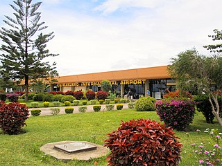
Kilimanjaro International Airport (KIA) (IATA: JRO, ICAO: HTKJ) is an international airport located in Hai District, Kilimanjaro Region, Tanzania. The airport serves the cities of Arusha and Moshi. The airport handled 802,731 passengers in 2014 and mainly serves regional flights as well as a few long-haul services due to its importance as a leisure destination. It is the largest airport in northern Tanzania, by size and passenger volume.

Moshi is a municipality and the capital of Kilimanjaro region in the north eastern Tanzania. As of 2017, the municipality has an estimated population of 201,150 and a population density of 3,409 persons per km2. In the last official census of 2022, the municipality had a population of 221,733. The municipality is situated on the lower slopes of Mount Kilimanjaro, a dormant volcano that is the highest mountain in Africa. The name Moshi has been reported to refer to the smoke that emanates from the nearby mountain. The municipality covers about 59 square kilometres (23 sq mi) and is the smallest municipality in Tanzania by area.

The Chagga are a Bantu ethnic group from Kilimanjaro Region of Tanzania. They are the third-largest ethnic group in Tanzania. They historically lived in sovereign Chagga states on the slopes of Mount Kilimanjaro in both Kilimanjaro Region and eastern Arusha Region.

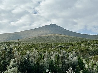
Mount Meru is a dormant stratovolcano located 70 kilometres (43 mi) west of Kilimanjaro in southeast Arusha Region, Tanzania. At a height of 4,562.13 metres (14,968 ft), it is visible from Mount Kilimanjaro on a clear day, and is the fifth-highest of the highest mountain peaks of Africa, dependent on definition.

Kilimanjaro Region is one of Tanzania's 31 administrative regions. The regional capital and largest city is the municipality of Moshi. With an HDI of 0.613, Kilimanjaro is one among the most developed regions of Tanzania. According to the 2012 national census, the region had a population of 1,640,087, which was lower than the pre-census projection of 1,702,207. For 2002-2012, the region's 1.8 percent average annual population growth rate was the 24th highest in the country. It was also the eighth most densely populated region with 124 people per square kilometer. The most well-known tribes in the Kilimanjaro region are the chagga, rombos, and pare.

Arusha Region is one of Tanzania's 31 administrative regions and is located in the north of the country. The region's capital and largest city is the city of Arusha. The region is bordered by Kajiado County and Narok County in Kenya to the north, the Kilimanjaro Region to the east, the Manyara and Singida Regions to the south, and the Mara and Simiyu regions to the west. Arusha Region is home to Ngorongoro Conservation Area, a UNESCO World Heritage Site. The region is comparable in size to the combined land and water areas of the state of Maryland in the United States.

Arusha National Park covers Mount Meru, a prominent volcano with an elevation of 4566 m, in the Arusha Region of north eastern Tanzania. The park is small but varied with spectacular landscapes in three distinct areas. In the west, the Meru Crater funnels the Jekukumia River; the peak of Mount Meru lies on its rim. Ngurdoto Crater in the south-east is grassland. The shallow alkaline Momella Lakes in the north-east have varying algal colours and are known for their wading birds.

Nyumba ya Mungu Dam is a Tanzanian, hydroelectric dam located in and operated in Mwanga District, Kilimanjaro Region. It was built in the late 1960s and is Kilimanjaro region's largest artificial water body. Nyumba ya Mungu Reservoir. The reservoir is shared with Moshi District of Kilimanjaro Region and Simanjiro District of Manyara Region. Nyumba ya Mungu means 'House of God'. Its installed capacity is 8 megawatts (11,000 hp).

The Arusha people are a Bantu ethnic and indigenous group based in the western slopes of mount Meru in Arusha District of Arusha Region in Tanzania. The Maasai regard the Arusha people as related as they were once a part of the immigrant Maasai whom arrived in Arusha in the late 18th century from Kenya. The Arusha people are not to be confused by Arusha residents who are a mix of people of different ethnic backgrounds that are born and reside within the borders of the Arusha Region.

Meru District, offcially the Meru District Council is one of seven districts of the Arusha Region of Tanzania.The District is bordered to the north by Longido District, to the east by Siha and Hai Districts of Kilimanjaro Region, to the south by Simanjiro District of Manyara Region, and to the west by Arusha Rural District and Arusha Urban District. It covers an area of 1,266 km2 (489 sq mi). The district is comparable in size to the land area of Faroe Islands. Meru District has an max elevation of 3,800 m (12,500 ft) at Rhino Point on Mount Meru. The administrative capital of the district is Usa River. According to the 2012 Tanzania National Census, the population of Meru District council was 268,144.

Tanzania contains some 20 percent of the species of Africa's large mammal population, found across its reserves, conservation areas, marine parks, and 17 national parks, spread over an area of more than 42,000 square kilometres (16,000 sq mi) and forming approximately 38 percent of the country's territory. Wildlife resources of Tanzania are described as "without parallel in Africa" and "the prime game viewing country". Serengeti National Park, the country's second largest national park area at 14,763 square kilometres (5,700 sq mi), is located in northern Tanzania and is famous for its extensive migratory herds of wildebeests and zebra while also having the reputation as one of the great natural wonders of the world. The Ngorongoro Conservation Area, established in 1959, is a UNESCO World Heritage Site and inhabited by the Maasai people. Its Ngorongoro Crater is the largest intact caldera in the world.

The Pangani River, is a major river of northeastern Tanzania. It has two main sources: the Ruvu, which rises as Lumi at Kilimanjaro, passes through Lake Jipe, and empties into the Nyumba ya Mungu Reservoir, and the Kikuletwa River, coming from the west and mainly fed by rivers of Mount Meru in Arusha Region, which also enters into the Nyumba ya Mungu Reservoir in Kilimanjaro Region. Just after leaving the reservoir the stream becomes the main Pangani, which empties into the Indian Ocean in Tanga Region at the Tangan port town of Pangani.
Mount Loolmalasin or Loolmalassin is a mountain located in the Ngorongoro District of the Arusha Region, Tanzania. It has a peak elevation of 3,682 metres (12,080 ft) above sea level. It is, after Mount Kilimanjaro and Mount Meru, the third-highest mountain in Tanzania if Kilimanjaro's three peaks are considered to be one mountain. The Mountain is located entirely within Nainokanoka ward. The volcano is located in the geographic area know as in the Crater Highlands and is an extinct volcano that last erupted in the pleistocene. Mount Loolmalasin is the second tallest mountain in Arusha Region and the highest point in Ngorongoro District. The mountain also is the source of Simiyu River, which flows west to Lake Victoria in Simiyu Region.

Arusha District or Arusha District Council is one of the seven districts of the Arusha Region of Tanzania. The district is bordered to the north by Longido District, to the east by Meru District, to the south by Kilimanjaro Region, and to the west by Monduli District. the district surrounds Arusha City on all three sides. The district covers an area of 1,547.6 km2 (597.5 sq mi). The district is comparable in size to the land area of Guadeloupe. The district capital is located in Sokon II. According to the 2012 Tanzania National Census, the population of Arusha District was 323,198.

Arusha Technical College (ATC) is a Tanzanian college, with its main campus located inside Ngarenaro ward, in the city of Arusha, Arusha Region. ATC is one of the largest and well established public coeducational post-secondary tertiary education institutions in Arusha Region. The college has three campuses: Main Campus in Arusha City, the second campus in located in Oljoro ward in Arumeru District, Arusha Region. The third campus is located in the small town Kikuletwa in Hai District, Kilimanjaro.
Songoro is an administrative ward in the Meru District of the Arusha Region of Tanzania. The ward covers an area of 114.0 km2 (44.0 sq mi), and has an average elevation of 1,285 m (4,216 ft). The ward is the source of the Kikuletwa River through the Tengeru River as a tributary which eventually leads to the Pangani River. According to the 2012 census, the ward has a total population of 11,139.
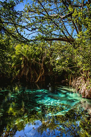
Kikuletwa Hot Springs, also known as Maji Moto(Maji Moto ya Kikuletwa in Swahili) and also Chemka Hot Springs, is a natural geothermal oasis located in Masama Rundugai ward of Hai District in the Kilimanjaro region of Tanzania. Chemka means "boiling" in Swahili, referring to the appearance of how the water emerges from the ground. The hot springs are located approximately 40 kilometers from the town of Moshi, which is a gateway to Mount Kilimanjaro in a village called Chemka. The hot spring waters flow into the Kikuletwa River and eventually find its way to the Pangani River.
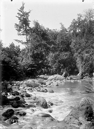
Kikafu River(Mto Kikafu in Swahili) is located in the northern Kilimanjaro Region, Tanzania. It begins in Machame Mashariki ward in Moshi District and drains into the Pangani River. The river plays an important part of Chagga history in the Chagga kingdom of Machame.
Sanya River is located in the northern Kilimanjaro Region of Tanzania. It begins in Livishi ward in Siha District and eventually drains into Kikuletwa River a tributary of the Pangani River. The river plays an important part of Chagga history in the Chagga kingdom of Siha (Kibongoto).

Ruvu Jipe River, also known as Luffu and Jipe Ruvu and Ruvu Pangani, is located in northern Kilimanjaro Region's Mwanga District of Tanzania. It begins in Kileo ward at Lake Jipe and eventually drains into Nyumba ya Mungu Dam and into Pangani River at Lang'ata ward.