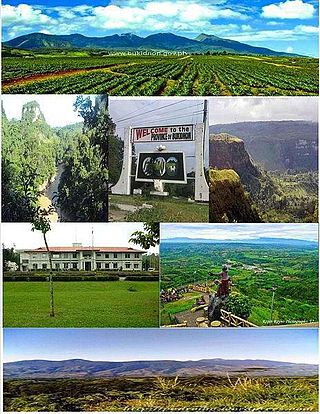
Bukidnon, officially the Province of Bukidnon, is a landlocked province in the Philippines located in the Northern Mindanao region. Its capital is the city of Malaybalay. The province borders, clockwise from the north, Misamis Oriental, Agusan del Sur, Davao del Norte, Cotabato, Lanao del Sur, and Lanao del Norte. According to the 2020 census, the province is inhabited by 1,541,308 residents. The province is composed of 2 component cities and 20 municipalities. It is the third largest province in the country in terms of total area of jurisdiction behind Palawan and Isabela respectively.

Malaybalay, officially the City of Malaybalay, is a 1st class component city and capital of the province of Bukidnon, Philippines. According to the 2020 census, it has a population of 190,712 people.

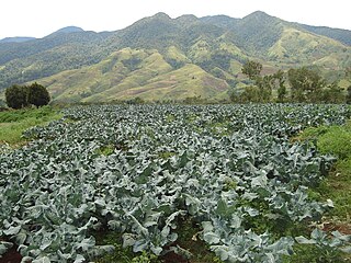
Lantapan, officially the Municipality of Lantapan, is a 1st class municipality in the province of Bukidnon, Philippines. According to the 2020 census, it has a population of 65,974 people.

Impasugong, officially the Municipality of Impasugong, is a 1st class municipality in the province of Bukidnon, Philippines. According to the 2020 census, it has a population of 53,863 people.
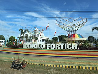
Manolo Fortich, officially the Municipality of Manolo Fortich, is a 1st class municipality in the province of Bukidnon, Philippines. According to the 2020 census, it has a population of 113,200 people.

Sumilao, officially the Municipality of Sumilao, is a 4th class municipality in the province of Bukidnon, Philippines. According to the 2020 census, it has a population of 29,531 people.

The Mindanao mountain rat or long-tailed moss mouse, is a species of rodent in the family Muridae. It is found only in the Philippines, where it is present at high altitudes in the Kitanglad Mountain Range on the island of Mindanao.
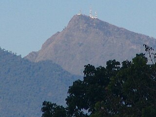
Mount Kitanglad is an inactive volcano located in the Kitanglad Mountain Range in Bukidnon province on Mindanao island. It is the fourth highest mountain in the Philippines and has an approximate height of 2,899 metres (9,511 ft). It is located between Malaybalay City and the municipalities of Lantapan, Impasugong, Sumilao, and Libona. It is home to one of the Philippines' few remaining rainforests.
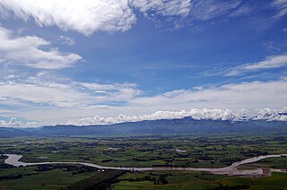
The Pulangi River ;, also spelled Pulangui, is one of the major tributaries of the Rio Grande de Mindanao, an extensive river system in Mindanao, Philippines. With a length of 320 kilometres (199 mi), it is the longest river in Bukidnon and the 5th longest river in the Philippines. It traverses through majority of the cities and municipalities of Bukidnon from its source in Barangay Kalabugao, Impasugong, Bukidnon.
The Kalatungan Mountain Range in the central portion of the province of Bukidnon, Philippines, is one of the few areas in the province covered with old growth or mossy forests. It covers an area of approximately 213.0134 km2 (82.24493 mi2), with about 113.7175 km2 (43.90657 mi2) identified as part of the critical watershed area declared under Presidential Decree 127, issued on June 29, 1987. The water from two rivers, the Muleta and Manupali Rivers, flood the multimillion dam project of the Philippine National Irrigation Administration (NIA). The rivers drain into the Pulangi River, the site of a National Power Corporation hydroelectric dam.

Mount Dulang-dulang, dubbed by Filipino mountaineers as "D2" and also known as Mount Katanglad, is the highest elevation peak in the Kitanglad Mountain Range, located in the north central portion of the province of Bukidnon in the island of Mindanao. It is the second highest mountain of the Philippines at 2,941 metres (9,649 ft) above sea level, second only to Mount Apo of Davao at 2,956 m (9,698 ft) and slightly higher than Mount Pulag of Luzon, the third highest at 2,928 m (9,606 ft).

Mount Malindang is a complex volcano located in the province of Misamis Occidental in the southern island of Mindanao, Philippines. It is the highest point in the province. The least studied mountain range was formed through several volcanic activities some of which could be historical, evident by the presence of two calderas, surrounded by high rock walls, cinder cones, dome volcano plugs, two sulfurous hot springs, and a crater lake named Lake Duminagat. The amphitheater structures have extensive distribution of volcanic rocks, carbonized wood that are found in pyroclastic deposits. The mountain range is dissected by several canyons and ravines.
Mount Kalatungan, also known as Catatungan, is a volcanic mountain located in the province of Bukidnon in the southern Philippines. It is a stratovolcano with no known historical eruptions and classified by the Philippine Institute of Volcanology and Seismology (PHIVOLCS) as a potentially active volcano.

Rafflesia schadenbergiana is a parasitic plant species of the genus Rafflesia. Known as "bó-o" to the Bagobo tribe and "kolon busaw" to the Higaonon tribe of Bukidnon, it has the largest flower among the Rafflesia species found in the Philippines with a diameter ranging from 52 to 80 centimeters. It has also the second largest flower in the genus after R. arnoldii.

The Flag of Bukidnon is the provincial flag of Bukidnon, Philippines. It is a horizontal triband of white, red and black, charged in the center with a yellow emblem consisting of a spear pointing downward toward the fly, and a shield which itself is charged with the stylized profile of the Kitanglad mountain range. The size of the flag is declared to be 34 inches by 64 inches, giving the flag a width-to-length proportion of 17:32. Bukidnon is one of the few Philippine provinces to have a flag whose design deviates from the standard provincial seal on a colored field.
Local elections were held in the province of Bukidnon on May 13, 2013 as part of the 2013 general election. Voters will select candidates for all local positions: a town mayor, vice mayor and town councilors, as well as members of the Sangguniang Panlalawigan, the vice-governor, governor and representatives for the four districts of Bukidnon.
Dalwangan is a barangay west of Malaybalay City situated on the foothills of the Kitanglad Range, 12 kilometers west of the city proper. It is bounded to the north by Impalutao of the municipality of Impasugong, to the east by Patpat and Kalasungay, to the south by Capitan Angel and the Mount Kitanglad Range Natural Park, and to the west by Kibenton of Impasugong. According to the 2015 census, Dalwangan has a population of 7,004 people.
Aglayan is an urban barangay of the City of Malaybalay in the Province of Bukidnon, Philippines. According to the 2015 census, Aglayan has a population of 7,594 people.
Imbayao is a rural barangay in Malaybalay, Philippines. It is located in the North Highway District and is almost entirely within the Kitanglad Mountain Range.
Mapayag is a rural barangay in the South Highway District of Malaybalay, Bukidnon, Philippines. According to the 2015 census, it has a population of 979 people.


