
Northern Mindanao is an administrative region in the Philippines, designated as Region X. It comprises five provinces: Bukidnon, Camiguin, Misamis Occidental, Misamis Oriental, and Lanao del Norte, and two cities classified as highly urbanized, all occupying the north-central part of Mindanao island, and the island-province of Camiguin. The regional center is Cagayan de Oro. Lanao del Norte was transferred to Northern Mindanao from Region XII by virtue of Executive Order No. 36 in September 2001.

Misamis Oriental, officially the Province of Misamis Oriental, is a province located in the region of Northern Mindanao in the Philippines. Its capital, largest city and provincial center is the city of Cagayan de Oro, which is governed independently from the province.

Gingoog, officially the City of Gingoog, is a 1st class component city in the province of Misamis Oriental, Philippines. According to the 2020 census, it has a population of 136,698 people.

Balingoan, officially the Municipality of Balingoan, is a 5th class municipality in the province of Misamis Oriental, Philippines. According to the 2020 census, it has a population of 11,020 people.

Initao, officially the Municipality of Initao, is a 3rd class municipality in the province of Misamis Oriental, Philippines. According to the 2020 census, it has a population of 33,902 people.
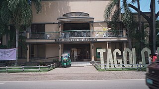
Tagoloan, officially the Municipality of Tagoloan, is a 1st class municipality in the province of Misamis Oriental, Philippines. It is located to the east of Cagayan de Oro and located south-east of Macajalar Bay. According to the 2020 census, it has a population of 80,319 people.
The legislative districts of Misamis were the representations of the historical province of Misamis in the various national legislatures of the Philippines until 1931. The undivided province's representation encompassed what are now the provinces of Camiguin, Misamis Occidental and Misamis Oriental, and the highly urbanized city of Cagayan de Oro.
The legislative districts of Misamis Oriental are the representations of the province of Misamis Oriental in the various national legislatures of the Philippines. The province is currently represented in the lower house of the Congress of the Philippines through its first and second congressional districts.

The University of Science and Technology of Southern Philippines is a state university system in the Philippines established on August 16, 2016, by virtue of Republic Act 10919 through the amalgamation of the Mindanao University of Science and Technology (MUST) in Cagayan de Oro and the Misamis Oriental State College of Agriculture and Technology (MOSCAT) in Claveria, Misamis Oriental. Both campuses are located in Northern Mindanao, considered the Gateway to Mindanao, which offers a strategic locational advantage for the institution to train and develop students from all the other regions of Mindanao.
Mount Balatukan is a massive potentially active compound stratovolcano in the northern island of Mindanao, Philippines. It is the highest point in the province of Misamis Oriental. The volcano has no historical eruptions but displays fumarolic activity. The 2,560-metre (8,400 ft) mountain is topped by a triangular shaped caldera 15 kilometers (9.3 mi) long and 10.6 kilometers (6.6 mi) at its widest. The Balatocan River emanates from and drains the huge crater.
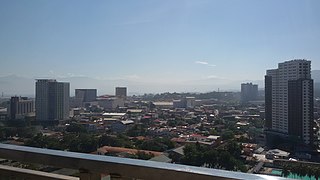
Cagayan de Oro (CDO), officially the City of Cagayan de Oro, is a 1st class highly urbanized city in the region of Northern Mindanao, Philippines. It is the capital of the province of Misamis Oriental where it is geographically situated but governed administratively independent from the provincial government. According to the 2020 census, it has a population of 728,402 people. Cagayan de Oro also serves as the regional center and business hub of Northern Mindanao, and part of the growing Metropolitan Cagayan de Oro area, which includes the city of El Salvador, the towns of Opol, Alubijid, Laguindingan, Gitagum, Lugait, Naawan, Initao, Libertad and Manticao at the western side, and the towns of Tagoloan, Villanueva, Jasaan, Claveria and Balingasag at the eastern side.
The Mati Protected Landscape is a protected area located in Davao Oriental on the southern Philippine island of Mindanao. It protects the watershed in Mati which is the source of water supply for the city's Mati Waterworks System. The protected area was established in 1967 when 890 hectares of forest in Central Mati was proclaimed as the Mati Watershed Forest Reserve through Proclamation No. 222 issued by President Ferdinand Marcos. Under the National Integrated Protected Areas System, the area was reclassified as a protected landscape with the signing of Proclamation No. 912 in 2005 by President Gloria Arroyo.

The Aliwagwag Protected Landscape is a protected area that preserves a major drainage catchment in the southern Philippine island of Mindanao in the Davao Region. It contains the headwaters of the Cateel River in the southern Diuata Mountain Range which provides the water source and irrigation for surrounding rice fields and communities in Davao de Oro and Davao Oriental provinces. It was named after the remote rural village in the municipality of Cateel where Aliwagwag Falls, the country's highest waterfall, is located.
The Mainit Hot Springs Protected Landscape is a protected landscape area located in the province of Davao de Oro on the island of Mindanao in the Philippines. It preserves the sulfuric hot springs and surrounding forest in Nabunturan municipality which also contains the headwaters of the Manat River, a source of water supply for surrounding villages. First declared a national park in 1957 by virtue of Proclamation No. 466 by President Carlos P. Garcia, it had an initial area of 1,381 hectares. Under the National Integrated Protected Areas System, it was reclassified as a protected landscape through Proclamation No. 320 issued in 2000 by President Joseph Estrada. The hot springs are a popular ecotourist attraction in Davao de Oro. Its name "Mainit" is a Filipino word which means hot.
The Calbayog Pan-as–Hayiban Protected Landscape, also known as the Calbayog Watershed, is a watershed and protected area located northwest of the city of Calbayog, Province of Samar in Oquendo District between Tinambacan District and San Isidro, Northern Samar in the Philippines. It is a mountainous region in the Tanaoan Ridge within the Mount Zamal Range that divides the three provinces of Samar. The protected area extends along the valley of the Hayiban River, the primary source of water for the Calbayog Water District. It consists of old growth trees and a system of rivers, waterfalls and streams capable of generating 2,279 liters per day. It also contains the Pan-as Falls and surrounding landscape which also supplies hydroelectric power to the city. The area was declared a forest reserve in 1967 known as the Pan-as Falls–Hayiban Watershed Forest Reserve with a total area of 7,832 hectares. In 1998, through Proclamation No. 1158 issued by President Fidel Ramos, the watershed was reclassified as a protected landscape. It is one of four protected areas in the island of Samar.
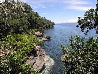
The Initao–Libertad Protected Landscape and Seascape is a protected area in western Misamis Oriental, Philippines. At 1,300.78 hectares, the park includes the limestone forests of the old Initao National Park, locally known as Lasang, as well as their adjacent marine waters in the municipalities of Initao and Libertad. Established in 2002, it is home to the Lasang Secret Adventure Park, a theme park which is being promoted by the provincial government as an eco-tourism and corporate events destination. The park is 27 kilometres (17 mi) southwest of the Laguindingan Airport and 59 kilometres (37 mi) west of the provincial capital Cagayan de Oro.

The Pantabangan–Carranglan Watershed Forest Reserve is a conservation area located in the upper reaches of the Pampanga River in Nueva Ecija, Philippines, and borders the Sierra Madre and Caraballo Mountains in Aurora and Nueva Vizcaya. It encompasses 84,500 hectares of the drainage basin surrounding the Pantabangan Lake, an impoundment of the Pampanga River by the Pantabangan Dam. The multi-purpose dam is situated at the confluence of Pampanga River's two headwaters, namely the Pantabangan and Carranglan Rivers in the municipality of Pantabangan. It stretches above the dam site for 21 kilometres (13 mi) to where Carranglan River originates in the Caraballo on the north, and for 18 kilometres (11 mi) to where Pantabangan River originates in the Sierra Madre on the east. It is considered a critical watershed for the agricultural economy and hydroelectric power generation in the region of Central Luzon.

The Butuan–Cagayan de Oro–Iligan Road, or Butuan–Cagayan de Oro–Iligan–Tukuran Road, is a 416-kilometer (258 mi), two-to-six lane major thoroughfare, connecting the provinces of Agusan del Norte, Misamis Oriental, Lanao del Norte, and Zamboanga del Sur.

The Gingoog–Claveria–Villanueva Road is a 70.9-kilometer (44.1 mi), two-to-four lane national secondary highway, connecting the municipalities of Villanueva and Claveria, and the city of Gingoog in Misamis Oriental. Traversing through the mountain range that includes Mount Balatukan, it serves as a diversion road from the Butuan–Cagayan de Oro–Iligan Road.

Misamis Oriental's 1st congressional district is one of the two congressional districts of the Philippines in the province of Misamis Oriental. It has been represented in the House of Representatives since 1987. The district encompasses the eastern half of the province consisting of the city of Gingoog and the municipalities of Balingasag, Balingoan, Binuangan, Kinoguitan, Lagonglong, Magsaysay, Medina, Salay, Sugbongcogon and Talisayan. It is currently represented in the 18th Congress by Christian Unabia of the Lakas–CMD.
