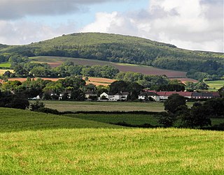
Knoll Camp

Last updated
Knoll Camp
Damerham Knoll - geograph.org.uk - 24134.jpg
Hampshire UK location map.svg
Archaeological site icon (red).svg
Shown within Hampshire
Alternative nameDamerham Knoll
Location Hampshire
Coordinates 50°57′58″N1°51′36″W / 50.9660°N 1.8599°W / 50.9660; -1.8599 Coordinates: 50°57′58″N1°51′36″W / 50.9660°N 1.8599°W / 50.9660; -1.8599
Area4 acres
History
PeriodsIron Age
Site notes
Public accessYes

Knoll Camp, or Damerham Knoll, is the site of an Iron Age univallate hill fort located in Hampshire. The fort comprises a circular earthwork containing about four acres. There is a single ditch with inner rampart and traces of counter scarp bank. [1] [2] The site is a scheduled ancient monument no.118. Grim's Ditch also runs throughout this area. The footpath/bridleway from the nearby long barrows of Grans Barrow and Knap Barrow runs southeast along the ridge through the centre of the hill fort, leaving through the original SE entrance, [3] and you could easily miss the ditch and bank as you cross it. The interior is thickly wooded and brambled. [4]

There is also a probable Iron Age Cross Ridge close by, described as Damerham Knoll, 50m west of Knoll Camp and comprises a shallow ditch with fragmentary remains of a bank on the west side. grid reference SU098185 [2]

Location

The site is located at grid reference SU099185 , to the west of the village of Rockbourne in the county of Hampshire. The hill has a summit of 132m AOD.

Related Research Articles

Martin, Hampshire Human settlement in England

Martin is a village and civil parish in the New Forest district in Hampshire. The nearest town Fordingbridge is 7 miles (11 km) to the southeast, and the cathedral city of Salisbury is 12 miles (19 km) to the northeast.

Bradley hill fort hillfort in Cheshire West and Chester

Bradley hill fort is an Iron Age hill fort. Hill forts were fortified hill-tops, used as settlements or temporary refuges, constructed across Britain during the Iron Age. It is the smallest of the seven hill forts in the county of Cheshire in northern England. It is protected as a Scheduled Ancient Monument.

Oakmere hill fort hillfort in Cheshire West and Chester

Oakmere hill fort is an Iron Age hill fort, one of many large fortified settlements constructed across Britain during the Iron Age, but one of only seven in the county of Cheshire in northern England. It is protected as a Scheduled Ancient Monument. Despite being a low-lying site, Oakmere is still considered a hill fort.

Ladle Hill Mountain in United Kingdom

Ladle Hill lies on Great Litchfield Down, near the village of Burghclere and Watership Down, in north Hampshire. It is immediately to the east of Beacon Hill. Part of the hill is a 10.37 hectares biological SSSI, number 1000642, first notified in 1978. It is 232 metres high and has a hillfort and a tumulus on its slopes. The hill is easily accessed from the nearby cross county footpath, Wayfarer's Walk. The hill falls within the North Wessex Downs Area of Outstanding Natural Beauty.

Bury Hill hillfort in Hampshire

Bury Hill is the site of a former Iron Age hillfort about 1.5 miles (2.4 km) southwest of the centre of Andover, Hampshire. The site encloses about 22 acres (8.9 ha). There are evident two stages to the construction of the fort, the first is a low single rampart and ditch, to the north and west of the second, stronger double rampart and ditch earthworks, part of which overlies the earlier work. The banks and the ditch are apparently in good condition, although fairly heavily wooded. A footpath encircles the hill fort on the inner rampart, accessible from the northeast and southwest. The centre is left to grass and very secluded, but is not accessible to the general public. The site was used well into the Roman era and was used as a camp by King Canute in 1016, when he fought Edmund Ironside in the Battle of Andover.

Frankenbury Camp

Frankenbury Camp is the site of an Iron Age univallate hillfort located in Hampshire. The site is on a very slight promontory overlooking the Avon Valley on the north-western edge of the New Forest. The fort encloses approximately 11 acres. It has very steep natural slopes on the west and south sides. The northeast sides are defended by a simple rampart and ditch. The original entrance on the southeast corner has since been widened. It is listed as a scheduled ancient monument no.122. The site is currently pasture, and part of Folds Farm, for the most part, although the earthworks themselves are lined with trees and the south and western parts are now encroached by woodland. Various archaeological relics have been found in the area:

Gorley Hill hillfort in Hampshire

Gorley Hill is the site of a former Iron Age promontory hillfort located in Hampshire in the United Kingdom.

Norsebury Ring

Norsebury Ring is the site of an Iron Age univallate hillfort located in Hampshire. Now mostly ploughed out to the South and east, some ditches and ramparts remain within a small copsed area to the North and west, which are surprisingly intact with a small outer ditch, then a bank, then another larger ditch followed by larger bank. However the trees and undergrowth hide the earthworks from immediate view.

Quarley Hill site of an Iron Age univallate hillfort in Hampshire, southern England

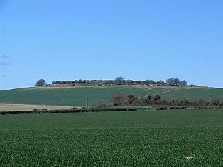
Quarley Hill is the site of an Iron Age univallate hill fort in Hampshire, southern England. The hill affords commanding views of the surrounding countryside.

Tidbury Ring hillfort in Hampshire

Tidbury Ring is the site of an Iron Age univallate hillfort located in Hampshire. The earthworks have been heavily destroyed by ploughing, but some sections to the south remain in better condition. The entrance lies to the southeast of the fort. The interior is for the most part farmland with the earthworks now covered by small trees and undergrowth Two Roman buildings, possibly a courtyard villa complex were found within the hill-fort. The site is now listed as a scheduled ancient monument no.87

Toothill Fort

Toothill Fort, or Toothill Ring, or Toothill camp, is the site of an Iron Age univallate hill fort located in Hampshire. The site occupies an extremely strong position at the north end of a spur. Its defences comprise a single rampart and ditch with traces of a counterscarp bank in places. There is an additional scarp on the north side up to 2.0m in height where the site is weakest. The original entrance is onto the ridge to the south.

Whitsbury Castle hillfort in Hampshire

Whitsbury Castle, or Whitsbury Castle Ditches, is the site of an Iron Age univallate hillfort located near the village of Whitsbury in Hampshire. The fort is roughly pear-shaped, located on a chalk outcrop, and covering approximately sixteen acres. The defenses comprise two large ramparts with outer ditches and an additional counter scarp bank on the northern half. The original entrance was at the southwestern corner but has been destroyed by the construction of a post-medieval manor house. The site has been in use throughout the ages, with excavation revealing mesolithic activity, an association with a Bronze Age ranch boundary, an Iron Age hillfort settlement, followed much later by Anglo-Saxon renovation and reuse of the defences. The site is privately owned but is flanked externally on all sides but east by public bridleways.

Woolbury

Woolbury, or Woolbury Ring, is the site of an Iron Age univallate hill fort on Stockbridge Down, Hampshire, England.

Bussock Camp hillfort in West Berkshire

Bussock Camp is the site of an Iron Age bivallate hillfort located in Berkshire. It has a double bank and ditch to the south and east, with only a single bank remaining the north and western sides. The entrance is to the north of the site and is believed to be original, and the site encloses approximately 11 acres

Perborough Castle hillfort in West Berkshire, UK

Perborough Castle is the site of an Iron Age univallate hillfort located at Compton in Berkshire. The site covers approximately 14 acres (5.7 ha), and lies on the chalky downs of West Berkshire. Archaeological evidence, from excavations in 1838, suggest that it was a lightly defended and perhaps a seasonally occupied site, containing no more than a few grain storage pits and slag pits, the extent of these being the obvious sign of continued occupation.

Bincknoll Castle site of a possible Iron Age univallate hillfort located in Wiltshire, England

Bincknoll Castle, or Bincknoll Camp, is the site of a possible Iron Age univallate hillfort located in Wiltshire. The site lies on the end of a triangular promontory on the escarpment beneath the Ridgeway to the South. The steeply contoured sides offer excellent natural defences with only the level lands to the south offering easy access. The suggestion that the site originates in the Iron Age is currently unproven. Pottery found on site has been Roman or later in date. Geophysical fieldwork is planned in the near future,(date?) hopefully that will inform the debate about the castle's chronology. Pronounced ‘Bynol’ Castle, the current earthworks appear to demonstrate a Norman motte and bailey castle of considerable natural strength. It is likely that Gilbert of Breteuil, after the Norman conquest, acquired a block of manors centred on Broad Hinton and built the castle to oversee them. The 'motte', now severely mutilated by later quarrying, measures approximately 52 metres in diameter by 3 metres high, and its ditch is 2.3 metres deep. The inner enclosure has a bank and ditch 3.4 metres high dividing it from the outer enclosure, with a causeway entrance. The earthworks of the now deserted hamlet of Bincknoll, which grew up outside the castle, may be discerned in Bincknoll Dip, sloping away to the north.

Chiselbury site of an Iron Age univallate hillfort located in Wiltshire, England

Chiselbury is the site of an Iron Age univallate hillfort located in Wiltshire. The hillfort is sub-circular in plan, and encloses an area of approximately 10.5 acres (460,000 sq ft). It is defined by an earthen rampart up to 3.6 metres (12 ft) in height and an external ditch, up to a maximum of 1.6 metres (5.2 ft) in depth. A gap in the southeastern side of the rampart, and a corresponding causeway across the ditch, is thought to be the original entrance and is associated with a small 'D' shaped embanked enclosure, which is apparently visible on aerial photographs. Although the enclosure has subsequently been degraded by ploughing, it is still apparent as a series of low earthworks.

Chisenbury Camp site of an Iron Age univallate hillfort located in Wiltshire, England

Chisenbury Camp is the site of an Iron Age univallate hillfort located in Wiltshire, England. The site comprises a small circular 5 acre enclosure that was levelled in 1931. A post was part excavated while being demolished. The site was partially excavated in the 19th century and there were finds of ceramics, worked stone, worked animal bone and remains of human burial.

Membury Camp hillfort in Wiltshire, UK

Membury Camp, or Membury Fort, is the site of an Iron Age hill fort located on the borders of Wiltshire and Berkshire,. The site encompasses 14 hectares, and is situated in the south-western corner of a small plateau. The circular earthworks are completely shrouded in trees and inside the walls it is mostly arable farmland. To the northeast, in the Berkshire segment, the camp is totally wooded by a small copse, Walls Copse, which covers a quarter of the site. To the north and east the adjoining ground is flat, but to the south and west it falls away steeply, providing a natural defence. The camp consists of a single ditch with banks on either side and encloses and area measuring 390m by 490m. A gap in the east with inturning flanks is probably an original entrance though it is mutilated and overgrown. Other gaps in the banks appear to be more modern. A possible hut circle is visible as a cropmark situated at the south end of the hill fort. The east side of the earthwork has been partly destroyed by the construction of a wartime airfield, RAF Membury. The site has not been excavated but a number of prehistoric finds have been found in the vicinity. It is a scheduled ancient monument no. 228970 There have been several collections of pottery found, in 1977, 1980 and 1987 Other significant finds have also included for flint artefacts from the mesolithic era, and flint tools from the neolithic era, prior to the Iron Age.

Bratton Castle bivallate Iron Age hillfort on Bratton Down in Wiltshire, England

Bratton Castle is a bivallate Iron Age hill fort on Bratton Down, at the western edge of the Salisbury Plain escarpment. The hill fort comprises two circuits of ditch and bank which together enclose a pentagonal area of 9.3 hectares.
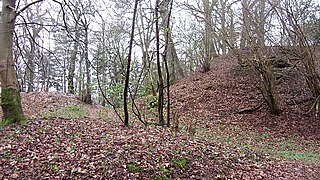
References

  1. Field Archaeology in Hampshire, 1915, (Williams-Freeman), p.400.
  2. 1 2 http://www.hants.gov.uk/hampshiretreasures/vol05/page076.html Archived 2016-03-04 at the Wayback Machine Hampshire Treasures website
  3. http://www.megalithic.co.uk/article.php?x=409900&y=118500 The Megalithic Portal
  4. http://www.themodernantiquarian.com/site/4159/knoll_camp.html The Modern Antiquarian: Knoll Camp