Rockbourne

Last updated

Rockbourne
Rockbourne Village - geograph.org.uk - 1921827.jpg
Rockbourne
Hampshire UK location map.svg
Red pog.svg
Rockbourne
Location within Hampshire
Population319  [1]
331 (2011 Census) [2]
OS grid reference SU114183
District
Shire county
Region
Country England
Sovereign state United Kingdom
Post town FORDINGBRIDGE
Postcode district SP6
Dialling code 01725
Police Hampshire and Isle of Wight
Fire Hampshire and Isle of Wight
Ambulance South Central
UK Parliament
List of places
UK
England
Hampshire
50°57′49″N1°50′21″W / 50.9637°N 1.8391°W / 50.9637; -1.8391
Medieval farm buildings Medieval farm buildings, Rockbourne - geograph.org.uk - 739462.jpg
Medieval farm buildings
Church of St Andrew Church of St Andrew - Rockbourne - geograph.org.uk - 655172.jpg
Church of St Andrew
Rockbourne Roman Villa Roman Villa at Rockbourne - geograph.org.uk - 223411.jpg
Rockbourne Roman Villa

Rockbourne is a village and civil parish in the English county of Hampshire, close to Fordingbridge.

Contents

Overview

Rockbourne is a village of thatched, brick and timber houses, next to a stream now known as Sweatfords Water. [3] The village consists chiefly of one street almost half a mile long. [4] The church is in the northeast of the main street. Close to the church, adjoining the north side of the churchyard, is a manorial complex consisting of small L-shaped 14th-century house, now used as part of a modern farmhouse; the remains of a large Elizabethan or Jacobean house a short distance to the east; a 13th-century chapel near its southeast angle; and a large 15th-century barn running northward from the chapel. [4]

The village is home to the oldest Cruck framed building in Hampshire. [5] The building which was being used as a barn in the early 90s is part of the manor and dates from the first half of the 1280s. [5]

History

Rockbourne has a long history of human habitation. Three Neolithic long barrows are known within the parish boundaries, as well as the sites of over twenty Bronze Age bowl barrows. [6] At Knoll Camp, there is also the site of an Iron Age Hill fort with a single bank and ditch. [7] At West Park, Rockbourne Roman Villa has been excavated since the 1950s, revealing over 70 rooms, several with mosaic floors and hypocausts. [8] The collection of finds from the site have been housed permanently in the museum building on the site, which is the only villa site in Hampshire open to the public. [8]

The name Rockbourne, recorded as Rocheborne in 1086, may derive from Old English "Hrocaburna", Rooks' stream, [9] or perhaps Rocky stream. [3] In the earliest records Rockbourne was a royal manor. In the Domesday Book of 1086, Alwy son of Turber held a hide there which Wulfgeat had previously held of King Edward. [10] Saewin also held half a hide of the gift of King Edward, [10] to which the sheriff in 1086 made an unsuccessful claim as part of the king's farm, but which at a later date reverted to the Crown. [4]

Alwy was succeeded here as in Hale and Tytherley by the Cardenvilles, and in the 13th century William Cardenville held a free tenement in Rockbourne. [4] Before 1156 the manor had been granted to Baron Manser Bisset. He was succeeded before 1177 by a son Henry, and whose widow Iseuld was holding Rockbourne early in the next century. [4] Their eldest son William died c. 1220, and was succeeded by his brother John, who died in 1241. Rockbourne passed to his daughter Ela, and then to her son John who assumed his mother's surname. [4] He died in 1307, leaving a son John, who died unmarried in 1334, leaving the manor to his sister Margaret, at that time the wife of Robert Martin, on whom the manor was settled in 1338. [4]

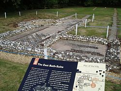
Early in 1336 Robert Martin complained that a certain John de Crucheston (Crux Easton) and others had abducted Margaret his wife and taken away his goods. Not waiting for justice, he retaliated by breaking into the house of John de Crucheston and seizing his property. [4] Some years later he took Crucheston prisoner, torturing him "with cords tied round his head and other torments, and extorting £1,150 from his friends for his release." [4] Robert Martin died in 1355, his wife surviving him until 1373, when the manor passed to her eldest son by her first husband, Sir Walter de Romsey. [4] It then passed by inheritance into the Keilway family, it being held by John Keilway on his death in 1547. [4] His son Francis died in 1601–2, and his son Thomas succeeded to Rockbourne, which, already heavily mortgaged to Sir Anthony Ashley, he sold in 1608 to Sir Anthony's son-in-law, Sir John Cooper. Sir John Cooper was succeeded by his eldest son Anthony Ashley Cooper, created Earl of Shaftesbury in 1672, and the manor descended with the Earls of Shaftesbury. [4]

The nearby manor of Rockstead, which Aldwin held before 1066, belonged to Hugh de Port in 1086. [11] Rockstead had passed to Breamore Priory before 1291. It belonged to the priory at the Dissolution and was granted with its other possessions to Henry Courtenay, 1st Marquess of Exeter and Gertrude his wife in November 1536. [4] Escheating to the Crown in 1539, it was granted to Anne of Cleves, but in 1548 passed to Sir Thomas Henneage and William Lord Willoughby, who in the following year sold it to William Keilway. [4] After this date it followed the descent of Rockbourne and became merged in that manor, its name only surviving in Rockstead Farm. [4]

Rockbourne Roman Villa

Rockbourne Roman villa once stood in the centre of a large farming estate, and is the largest known villa in the area. [12] Its history spans the period from the Iron Age to the 5th century. [12] The villa included bath houses, living quarters, farm buildings and workshops. [12] Much of the villa is on public display and there is a site museum, with excavated artefacts, tracing the villa's history. [12]

Saint Andrew's church

The 11th/12th-century church of Saint Andrew is a flint structure with a tiled roof, and a timber and wood tiled belfry. [8] Originally cruciform, it bears the remains of an 11th-century Saxon north door and north transept arch. [8] The church was enlarged in the 13th, 16th and 17th centuries. [8] There is a 14th-century chantry chapel restored in the 19th century. [8]

Notes

  1. "2001 Census Neighbourhood Statistics – Civil Parishes in the New Forest". www.neighbourhood.statistics.gov.uk. Retrieved 10 July 2011.
  2. "Civil Parish Population 2011". Neighbourhood Statistics. Office for National Statistics. Retrieved 7 January 2016.
  3. 1 2 Hampshire Treasures Volume 5 (New Forest) Page 281, retrieved 12 October 2011
  4. 1 2 3 4 5 6 7 8 9 10 11 12 13 14 15 Victoria County History of Hampshire: Rockbourne
  5. 1 2 Roberts, Edward (2003). "True Crucks and Related Frames". Hampshire Houses 1250-1700: Their Dating and Development. Hampshire County Council. p. 20. ISBN   1859756336.
  6. Hampshire Treasures Volume 5 (New Forest) Page 283, retrieved 12 October 2011
  7. Hampshire Treasures Volume 5 (New Forest) Page 284, retrieved 12 October 2011
  8. 1 2 3 4 5 6 Hampshire Treasures Volume 5 (New Forest) Page 285, retrieved 12 October 2011
  9. Rockbourne, Old Hampshire Gazetteer
  10. 1 2 Domesday Map – Rockbourne
  11. Domesday Map – Rockstead
  12. 1 2 3 4 Rockbourne Roman Villa

Related Research Articles

<span class="mw-page-title-main">Fordingbridge</span> Town in Hampshire, England

Fordingbridge is a town and broader civil parish with a population of 6,000 on the River Avon in the New Forest District of Hampshire, England, near the Dorset and Wiltshire borders and on the edge of the New Forest, famed for its late medieval seven-arch bridge.

<span class="mw-page-title-main">Marchwood</span> Human settlement in England

Marchwood is a village and civil parish located in Hampshire, England. It lies between Totton and Hythe on the western shore of Southampton Water and directly east of the New Forest. The population of the village in the 2011 census was 6,141.

<span class="mw-page-title-main">Lyndhurst, Hampshire</span> Village in Hampshire, England

Lyndhurst is a large village and civil parish situated in the New Forest National Park in Hampshire, England, about nine miles (14 km) south-west of Southampton. Known as the "Capital of the New Forest", Lyndhurst houses the New Forest District Council and Court of Verderers. It is also a popular tourist attraction, with many independent shops, art galleries, cafés, museums, pubs and hotels. As of 2001 Lyndhurst had a population of 2,973, increasing to 3,029 at the 2011 Census.

<span class="mw-page-title-main">Hordle</span> Human settlement in England

Hordle is a village and civil parish in the county of Hampshire, England. It is situated between the Solent coast and the New Forest, and is bordered by the towns of Lymington and New Milton. Like many New Forest parishes Hordle has no village centre. The civil parish includes the hamlets of Tiptoe and Everton as well as part of Downton. The parish was originally much larger; stretching from the New Forest boundary to Hurst Castle.

<span class="mw-page-title-main">Dibden</span> Human settlement in England

Dibden is a small village in Hampshire, England, which dates from the Middle Ages. It is dominated by the nearby settlements of Hythe and Dibden Purlieu. It is in the civil parish of Hythe and Dibden. It lies on the eastern edge of the New Forest in a valley, which runs into Southampton Water.

<span class="mw-page-title-main">Minstead</span> Human settlement in England

Minstead is a small village and civil parish in the New Forest, Hampshire, about 2 miles (3.2 km) north of Lyndhurst. There is a shop and a pub, the Trusty Servant. Sir Arthur Conan Doyle's grave is under a large tree at the back of the 13th century All Saints' church.

<span class="mw-page-title-main">Whitsbury</span> Human settlement in England

Whitsbury is a village and civil parish in Hampshire, England, close to Fordingbridge. Whitsbury is a part of a group of villages on the edge of the Cranborne Chase and West Wiltshire Downs Area of Outstanding Natural Beauty.

<span class="mw-page-title-main">Breamore</span> Human settlement in England

Breamore is a village and civil parish near Fordingbridge in Hampshire, England. The parish includes a notable Elizabethan country house, Breamore House, built with an E-shaped ground plan. The Church of England parish church of Saint Mary has an Anglo-Saxon rood.

<span class="mw-page-title-main">Dinton, Wiltshire</span> Village in Wiltshire, England

Dinton is a village, civil parish and former manor in Wiltshire, England, in the Nadder valley on the B3089 road about 8 miles (13 km) west of Salisbury. The parish population was 696 at the 2011 census, estimated at 733 in 2019. The civil parish includes the village of Baverstock, about 1 mile (1.6 km) east of Dinton village.

<span class="mw-page-title-main">Hale, Hampshire</span> Human settlement in England

Hale is a small village and civil parish in Hampshire, England. It lies on the border of the New Forest, overlooking the valley of the River Avon. The village is about 3.5 miles (5.6 km) north-east of the town of Fordingbridge, and about 8 miles (13 km) south of the city of Salisbury. Within the parish stands Hale House, a large 18th-century mansion which was the country house of architect Thomas Archer, who also rebuilt Hale church in 1717.

<span class="mw-page-title-main">Colbury</span> Village in Hampshire, England

Colbury is a small village in the New Forest National Park, in Hampshire, England. The village lies along Deerleap Lane, near the modern village of Ashurst.

<span class="mw-page-title-main">South Charford</span> Human settlement in England

South Charford is a hamlet in the New Forest district, in Hampshire, England. It is in the civil parish of Breamore on the west bank of the River Avon.

<span class="mw-page-title-main">North Charford</span> Human settlement in England

North Charford is a hamlet in the New Forest district, in Hampshire, England, near the Wiltshire border. Historically the name refers to a manor which is now in the civil parish of Breamore on the west bank of the River Avon.

<span class="mw-page-title-main">Bickton</span> Human settlement in England

Bickton is a hamlet in the New Forest District of Hampshire, England. It is within the civil parish of Fordingbridge and is situated by the River Avon.

<span class="mw-page-title-main">Battramsley</span> Human settlement in England

Battramsley is a hamlet in the civil parish of Boldre, in the New Forest in Hampshire, England.

<span class="mw-page-title-main">Ellingham, Hampshire</span> Human settlement in England

Ellingham is a small village and former civil parish, now in the parish of Ellingham, Harbridge and Ibsley, in the New Forest district, in the county of Hampshire, England. It is near Ringwood, west of the New Forest National Park. Ellingham is most famous for the story of Alice Lisle, who was executed by the infamous Judge Jeffreys in 1685, on the charge of harbouring fugitives after the defeat of the Monmouth Rebellion. In 1961 the parish had a population of 595.

<span class="mw-page-title-main">Langley, Hampshire</span> Human settlement in England

Langley is a small village in the civil parish of Fawley in Hampshire, England.

<span class="mw-page-title-main">Shalden</span> Human settlement in England

Shalden is a village and civil parish in the East Hampshire district of Hampshire, England. It is 2.3 miles (3.7 km) northwest of Alton and 1.9 miles (3.1 km) northeast of Bentworth, just off the A339 road. The parish covers an area of 1,536 acres (622 ha) and has an average elevation of 600 feet (180 m) above sea level. The nearest railway station is Alton, 2.5 miles (4.0 km) southeast of the village. According to the 2011 census, it had a population of 435.

<span class="mw-page-title-main">North Gorley</span> Human settlement in England

North Gorley is a hamlet in the New Forest National Park of Hampshire, England. Its nearest town is Fordingbridge, which lies approximately 2 miles (3.2 km) north of the hamlet.

<span class="mw-page-title-main">Avon Tyrrell House</span> Historic manor within the parish of Sopley, Hampshire

Avon Tyrrell is an historic manor within the parish of Sopley, Hampshire. It is situated within the New Forest, near Christchurch. The present manor house was built in 1891 by John Manners-Sutton, 3rd Baron Manners (1852–1927).