
Salzburg is an Austrian federal state. In German it is called a Bundesland, a German-to-English dictionary translates that to federal state and the European Commission calls it a province. In German, its official name is Land Salzburg, to distinguish it from its eponymous capital Salzburg. For centuries, it was an independent Prince-Bishopric of the Holy Roman Empire. It borders Germany and Italy.

The Salzach is a river in Austria and Germany. It is 227 kilometres (141 mi) in length and is a right tributary of the Inn, which eventually joins the Danube. Its drainage basin of 6,829 km2 (2,637 sq mi) comprises large parts of the Northern Limestone and Central Eastern Alps. 83% of its drainage basin lies in Austria, the remainder in Germany (Bavaria). Its largest tributaries are Lammer, Berchtesgadener Ache, Saalach, Sur and Götzinger Achen.

The Kitzbühel Alps are a mountain range of the Central Eastern Alps surrounding the town of Kitzbühel in Tyrol, Austria. Geologically they are part of the western slate zone.
Kaprun is a municipality in the Zell am See District in the province of Salzburg in Austria. Together with the neighboring city of Zell am See the town presents itself as the tourist destination and skiing area "Zell am See-Kaprun". Kaprun distinguishes itself from its larger neighbor at the lake, by offering all year access to the Kitzsteinhorn with its Top of Salzburg viewing platform at 3029 metres (9938') altitude and its glacier ski area that is open October through May.
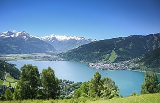
Zell am See is the administrative capital of the Zell am See District in the Austrian state of Salzburg. Located in the Kitzbühel Alps, the town is an important tourist destination due to its ski resorts and shoreline on Lake Zell. While Zell am See has been a favored winter and summer resort for the European aristocracy since the 19th century, it is known as a hub of the international jet set today.

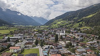
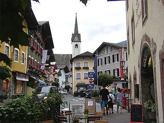
Mittersill is a city in the federal state of Salzburg, Austria, in the Pinzgau region of the Alps. It is located on the Salzach River. It has a population of 5,408 as of 2011.

Fusch an der Großglocknerstraße is a municipality, at the foot of Grossglockner mountain, in the district of Zell am See, in the state of Salzburg in Austria. The Fusch valley lies north of the main chain of the Alps. The population is 697. Fusch has an elevation of 813 metres (2,667 ft), but the maximum elevation within the municipality is 3,564 metres (11,693 ft), rising up Grossglockner mountain.

Saalfelden am Steinernen Meer is a town in the district of Zell am See in the Austrian state of Salzburg. With approximately 16,000 inhabitants, Saalfelden is the district's largest town and the third of the federal state after Salzburg and Hallein.

Radstadt is a historic town in the district of St. Johann im Pongau in the Austrian state of Salzburg.

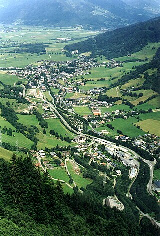
Bruck an der Großglocknerstraße is a municipality in Zell am See District, in the state of Salzburg in Austria.
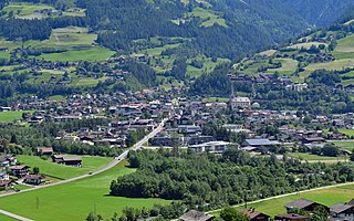
Bramberg am Wildkogel is a municipality in the district of Zell am See, in the state of Salzburg, Austria. The town lies at the south foot of the 2,225-metre (7,300 ft) high Wildkogel mountain. The town's average elevation is 819 metres (2,687 ft).
Matrei in Osttirol is a market town in the Lienz District in the Austrian state of Tyrol. It is situated about 29 km (18 mi) north of Lienz within the Hohe Tauern mountain range of the Central Eastern Alps. Its municipal area comprises parts of the Granatspitze Group and the Venediger Group, with the Großvenediger peak as its highest point. The population largely depends on tourism, seasonal agriculture and forestry.
Golling an der Salzach is a market town in the Hallein district of Salzburg, Austria.
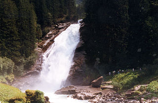
The Krimml Waterfalls, with a total height of 380 metres, are the highest waterfall in Austria. The falls are on the Krimmler Ache river and are located near the village of Krimml in the High Tauern National Park in Salzburg state.

The Venediger Group is a mountain range of the Central Eastern Alps. Together with the Granatspitze Group, the Glockner Group, the Goldberg Group, and the Ankogel Group, it forms the main ridge of the High Tauern. The highest peak is the Großvenediger at 3,657 m (AA), which gives its name to the group. Considerable parts of the Venediger Group belong to the core zone of the High Tauern National Park.
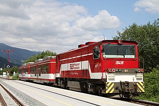
The Pinzgauer Lokalbahn is a narrow-gauge railway in Salzburg in Austria. The 53 kilometre railway follows the Salzach valley from Zell am See to Krimml through the Pinzgau mountains. The section between Mittersill and Krimml was damaged by flooding in 2005 and reopened in September 2010.
Hinterwaldberg is a dispersed settlement in the Oberpinzgau, the upper Salzach valley and the district of Zell am See/Pinzgau, and is a village and Katastralgemeinde in the municipality of Wald im Pinzgau, on the southern edge of the Kitzbühel Alps in Austria.
Vorderwaldberg is a dispersed settlement in the Oberpinzgau, the upper Salzach valley and the district of Zell am See/Pinzgau, and also a village in the municipality of Wald im Pinzgau, on the southern edge of the Kitzbühel Alps in Austria.
Lahn is a dispersed settlement in the Oberpinzgau, the upper Salzach valley and the district of Zell am See/Pinzgau, and a village in the municipality of Wald im Pinzgau, on the southern rim of the Kitzbühel Alps.
The Krimmler Ache is a river in the Pinzgau region of the Austrian state of Salzburg, a right tributary of the Salzach at Vorderkrimml, Wald im Pinzgau.


