Nowhatta, known as Navyut in Kashmiri, is a town of historical importance situated at a distance of 5 km from Lal Chowk, Srinagar in Jammu and Kashmir, India. Nowhatta is famous because of Historical Mosque known as Jamia Masjid. Nowhatta area has eighteen sub-communities Mohalla. The place is also notable for high rate of stone pelting incidents in Kashmir. Each week after Friday prayers, people stage their protest against Indian rule which most of the times results in stone pelting incidents in the area.

Bijbehara (Urdu pronunciation: [bɪd͡ʒbɪhaːɽaː], known as Vejibror in Kashmiri, is a town and a notified area committee in Anantnag district of the Indian administered union territory of Jammu and Kashmir. It is located on NH 44, and jehlum bank. Bijbehara town is also known as "Town of Chinars" because of a number of Chinars there especially two Chinar gardens. Bijbehara is the home to oldest chinar tree in the region. The town is situated about 45 km from the summer capital of union territory of Jammu and Kashmir, Srinagar.
Charar-i-Sharief (Urdu pronunciation: [t͡ʃəraːreː ʃərɪf], known as Tsrar-i-Sharif in Kashmiri, is a town and a notified area committee in the Budgam district of the union territory of Jammu and Kashmir, India.

Qazigund, also known as Gateway Of Kashmir, is a town and in the union territory of Jammu and Kashmir, India. Qazigund is located at 33.59°N 75.16°E. It has an average elevation of 1670 m (5478 feet) above mean sea level.
Kalusa or Kaloosa is a village in the Bandipore district of Jammu and Kashmir, India.
Doru Shahabad is a town and the headquarters of the Dooru tehsil in the Anantnag district of the Indian union territory of Jammu and Kashmir. It also known as a historical township in South Kashmir's Anantnag district. Doru Shahabad is considered place of intelligence, where great scholars like Mehmood shah Gami, Rasul Mir Shahabadi were born. These scholars contributed to the literature and culture of Kashmir. In present times, Shahabad has produced chief ministers such as Syed Mir Qasim, other politicians, bureaucrats, and leading agricultural scientists.
Achabal is the village in Baramulla district, Jammu and Kashmir |Jammu and Kashmir. It is around 5 km (3.1 mi) away from Sopore town. The village is surrounded by the villages of like Lorihama, Alsafa Colony, Ladoora and Ferozpora. This village is accessible by the National Highway from Ferozpora-Achabal link road which connects it to Handwara, Kupwara and other northern regions of Kashmir. It is also accessible by Ladoora-Sopore road. There is a branch of Jammu & Kashmir Bank in the main market.
Amlar is a village in the Pulwama district of the Indian union territory of Jammu and Kashmir. It lies at a distance of almost 35 km from Srinagar and 6 km from main Tral town and 5 km from Awantipora. Its nearby villages are Nowpora, Lariyar, and Poshwan. On the Khandaypora side, it is surrounded by a low mountain (Wudur).
Rajbagh is the notified area in the municipal committee of Srinagar, in the Indian union territory of Jammu and Kashmir. It comes under the Amira Kadal Constituency. Rajbagh is a posh locality in the civil line area of Srinagar. The postal code of Rajbagh is 190008. Rajbagh is considered one of the many best residential places in Srinagar. There are many hotels, restaurants and schools in this locality. Rajbagh area was heavily damaged by the 2014 Kashmir floods, it was one of the worst affected areas due to flood.

Lal Bazar is a locality in the municipal committee of Srinagar in the Indian administered union territory of Jammu and Kashmir. It comes under the Zadibal constituency of the Srinagar Legislative Assembly. Lal Bazar is a well known posh area in the upper downtown area of Srinagar. The Pincode of Lal Bazar is 190023. Considered amongst the best residential areas in Srinagar the area has many amenities such as major banks and schools along with University of Kashmir,NIT Srinagar, Institute of Technology, University of Kashmir, Zakura Campus, Sher - i - Kashmir Institute of Medical Sciences close by, roughly 2 km from Lal Bazar.
Wakura is a village located in the Ganderbal district of Jammu and Kashmir, India. In 2013 it was given tehsil status, with the tehsil headquarters located in Lar, 13 km away.
Sonwar Bagh, sometimes referred to as Sonwar, is a residential area in Badami Bagh Cantonment on the outskirts of Srinagar city, in Srinagar district, Jammu and Kashmir, India. It is gradually becoming more commercial, as many schools, hotels and restaurants have been established there.
Aripanthan is a village and panchayat halqa in Beerwah tehsil of Budgam district in the Indian union territory of Jammu and Kashmir. It is situated at the centre of tehsil Beerwah and tehsil Magam. It is located about 27 km (17 mi) west from summer capital of Jammu and Kashmir, Srinagar and about 28 km (17 mi) north from district headquarters in Budgam.

Akingam is a village in South Kashmir in the Anantnag district, in the Indian union territory of Jammu and Kashmir. It is at a distance of approximately 14.2 kilometres (8.8 mi) from the Lal Chowk along a route passing through the tourist resorts of Achabal and Kokernag. In revenue records, the village of Akingam is still called Maqan Shiva Bhagwati. The adjacent villages are Mohripura, Hiller, Badasgam, Hardpora and Badoora.

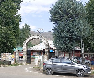
Shiva Bhagwati Temple Akingam is a temple of Jagad Amba Shri Shiva Bhagwati. The temple is famous in Kashmir valley
Lankreshipora is a moderate size village located almost 2.5 km from main Bandipora town in the Indian union territory of Jammu and Kashmir. It is an industrial area situated on the banks of Wular Lake and a canal called Mudhmati Nala. Almost forty percent of the population is directly or indirectly associated with local band saw industries. Lankreshipora is known to supply raw material like wooden boxes for fruit packaging mostly to South Kashmir districts like Anantnag, Kulgam, Pulwama. Most people are dependent on fishing, carpet weaving and other handicrafts. Lankreshipora has been ignored by the local politicians from decades due to which it is one of the most underdeveloped villages in the whole district. The literacy rate is almost below 20 percent, however, the new generation is showing promise both in education and sports. Lack of education, sanitary and medical facilities are evident.

Hathlangoo previously known as Hashmatpora is a village in the Sopore tehsil of Baramulla district, in the Indian union territory of Jammu and Kashmir. It is located 8 km (5.0 mi) away from sub-district headquarter Sopore and 22 km (14 mi) away from district headquarters Baramulla. It is one of the largest villages in Zaingair. The Hathlangoo village has Janwara Village in the South, Magraypora in the North, Botingoo in the Northwest, Malmapanpora in the West and Wular Lake in the East.
Gadiseer is a village in the Anantnag district in the Indian administered union territory of Jammu and Kashmir. It is located on the bank of Jhelum River. PIN code of Gadiseer is 192124 and its postal head office is Bijbehara. The village falls in the vicinity (jurisdiction) of tehsil Bijbehara in Dachnipora Block.
Narbal is a tehsil in central Kashmir's Beerwah sub-district. It is also a block in Budgam district in the Indian administered union territory of Jammu and Kashmir. It is 18 km (11 mi) away from sub-district headquarter Beerwah and 13 km (8.1 mi) away from Srinagar, the summer capital of Jammu and Kashmir.

Ichgam, also known as Ichigam, is a census town located in the Indian administered union territory of Jammu and Kashmir's Budgam district. It falls under the administrative division of tehsil Budgam, one of the nine tehsils of district Budgam. It is one of the most populated area of Budgam district. It is roughly 5 km (3.1 mi) away from district Budgam and nearly 19 km (12 mi) away from Srinagar, the summer capital of union territory of Jammu and Kashmir. Ichgam village consists of four blocks — Ichgam-A, Ichgam-B, Ichgam-C and Ichgam-D. The village consists of both major sects of Islam, Shias (85-90%) and Sunnis(10-15%). There is also a Hindu minority.


