Related Research Articles
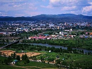
Anantnag, also called Islamabad, is the administrative headquarters of the Anantnag district in the Indian union territory of Jammu and Kashmir. It is located at a distance of 53 kilometres from the union territory's capital Srinagar. It is the third largest city in Jammu and Kashmir after Srinagar and Jammu with an urban agglomerate population of 159,838 and municipal limit population of 109,433.

Bijbehara is a town and a notified area committee in Anantnag district of the Indian administered union territory of Jammu and Kashmir. It is located on NH 44, connecting the Kashmir Valley with the rest of India. Bijbehara town is also known as "Chinar Town" because of two Chinar gardens which are known for their chinars trees. Bijbehara is the home to oldest chinar tree in the region. The town is situated about 45 km (28 mi) from the summer capital of union territory of Jammu and Kashmir, Srinagar.

Kulgam, known as Kolgom in Kashmiri, is a town, administrative division, and capital of the Kulgam district in the Indian union territory of Jammu and Kashmir. It is located at a distance of 67 km (42 mi) from the summer state capital of Jammu and Kashmir, Srinagar. The city is divided into 16 electoral wards that has population of 23,584, of which 12,605 are males while 10,979 are females.

Budgam district is a district in the Indian administered union territory of Jammu and Kashmir. Created in 1979 with its headquarters at Budgam, it is the district with the largest population of Shias in the Kashmir valley.

Shopian or Shupiyan, known as Shupyan in Kashmiri, is a hill district with its administrative division in Shopian, located in the Indian union territory of Jammu and Kashmir, since it is situated on the historical road commonly known as Mughal Road, most of its area is occupied by forests. Shopian district comes under the Pir Panjal Range which makes it very cold in winter. After partition of India, it was a tehsil of Pulwama district. In March, 2007, the district status was granted by the Government of India. The economy of the district depends on agriculture, particularly apple growing. Shopian is 22 km (14 mi) from Aglar which connects it with Pulwama district and is one of the border towns of the district.

Kulgam district is a district in the Indian union territory of Jammu and Kashmir. It is located at a distance of 18 km towards south-west of Anantnag. The district comprises block, tehsil and town of Kulgam.
Gantali Pora is a village in Bijbehara tehsil, Anantnag district, of the Indian union territory of Jammu and Kashmir. As of 2011 the village had a population of 713 split into 80 households with males forming 353(49.5%) of the populace and females 360(51.5). Its elevation is approximately 890m above MSL. While Urdu is the official language, Kashmiri is also mostly spoken.

Fatehpora also known as Fateh Pora & Fatehpura, is an economic hub area of Anantnag district in the union territory of Jammu and Kashmir, India. Fatehpora is located at 33.656027°N 75.160375°E. It has an average elevation of 1600 metres (5478 feet) above mean sea level.
Dialgam is a large village situated in Anantnag tehsil, in Anantnag district of Jammu and Kashmir. It is one of 150 villages in Anantnag Block along with villages like Hardu Shichan and Pal Pora.
Naw Wathu also termed as Nawathoo is a village in Anantnag tehsil in Anantnag district in the Indian union territory of Jammu and Kashmir. It is one of 105 villages in Anantnag block along with villages like Lali Pora, Mala Pora and Forah.
Nepora or Nipor is a village in Anantnag tehsil in Anantnag district in Jammu and Kashmir. The nearest railway station is Sadura railway station. A tributary of river Jehlum 'Sandran' flows through the village.
Isoo is a village in Anantnag tehsils in Anantnag district in Jammu and Kashmir, India.
Sifan is a village in Anantnag tehsil in Anantnag district in Jammu and Kashmir, India.
Shalwan Pora is a village in Anantnag tehsil in Anantnag district in Jammu and Kashmir, India.
Dooni Pahoo is a village in Anantnag Tehsils in Anantnag district in Jammu and Kashmir.
Brinty Bat Pora village is located in Anantnag tehsil of Anantnag district in Jammu and Kashmir, India.
Thajiwara is a village in South kashmir in the Anantnag district of the Indian union territory of Jammu and Kashmir. It is located on National Highway 244.
Shankerpora, also known as Shankerpur, is a village in Anantnag district in the Indian-administered union territory of Jammu and Kashmir.
Gadiseer is a village in the Anantnag district in the Indian-administered union territory of Jammu and Kashmir. It is located on the bank of Jhelum River. PIN code of Gadiseer is 192124 and its postal head office is Bijbehara. The village falls in the vicinity (jurisdiction) of tehsil Bijbehara in Dachnipora Block.
References
- 1 2 3 "District Census Handbook Anantnag" (PDF). Census of India 2011. pp. 11, 94. Archived from the original (PDF) on 1 December 2020.