
Gombe State is a state in northeastern Nigeria, bordered to the north and northeast by the states of Borno for 93 km in the vicinity of Gongola River and Lake Dadin Kowa and Yobe in the vicinity of Gongola River for 140 km, to the south by Taraba State for 58 km, to the southeast by Adamawa State for 95 km, and to the west by Bauchi State for 277 km. Gombe is the state capital of Gombe state and it was formed from a part of Bauchi State on 1 October 1996. Of the 36 states in Nigeria, Gombe is the 21st largest in area and the 32nd most populous, with an estimated population of about 3.25 million as of 2016. The state bears a slogan "Jewel in the Savannah".

Bauchi is a city in northeast Nigeria, the Administrative center of Bauchi State, of the Bauchi Local Government Area within that State, and of the traditional Bauchi Emirate. It is located on the northern edge of the Jos Plateau, at an elevation of 616 m. The Local Government Area covers an area of 3,687 km2 and had a population of 493,810 in 2006.
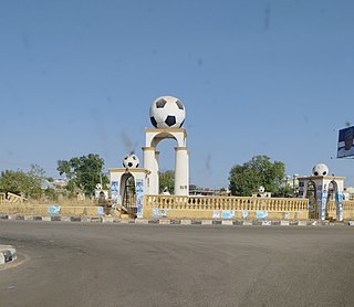
Gombe is the capital city of Gombe State, north-eastern Nigeria, with an estimated population of around 450,000. The major spoken languages in Gombe are Hausa and Fulfulɗe, Tera and Tangale.
Idemili South is a Local Government Area in Anambra State, South-East Nigeria. The headquarters is Ojoto secretariate which was built by Hon Sylva. G. Abasilim the first elected council chairman and was commissioned by Prof Audu Ogbe when he was the People's democratic party National chairman and this was done under Gov. Mbadinuju Chimaroke and the estimated number of people is 159,631. The towns that make up the local government are Akwu-Ukwu, Alor, Awka-Etiti, Ojoto, Nnokwa, Oba and Nnobi.
Onitsha North is a Local Government Area in Anambra State, South-East Nigeria. The headquarters is in GRA, Onitsha. Onitsha is the only town in Onitsha North and Onitsha South LGA. Onitsha North has a boundary by Idemili North and Oyi local government areas to the East, Anambra East local government area to the North, Onitsha South local government area by the South and Delta State by the West. But then, it has various localities that are residential areas for the population living in the local government area. These include Omagba Layout Phases 1 & 2, Inland Town, GRA, Federal Housing Estate Trans Nkisi GRA, Akpaka, Odoakpu, Ose, Omagba, etc. Onitsha North also has various primary and secondary schools owned by the government, individuals, and missions. It is also known as the city where the biggest market in West Africa is situated. However, Onitsha North has experienced several degrees of conflicts and riots. It was also affected by floods.
Onitsha South is a Local Government Area in Anambrs North Senatorial zone of Anambra State, Nigeria. The headquarters is in Fegge, Onitsha. Onitsha South is predominantly commercial with popular markets such as Ochanja market which attracts thousands of buyers and sellers of variety of commodities. The revenue of Onitsha South Local Government Area is generated mostly from commercial activities.
Anambra East is a Local Government Area in Anambra State, south-central Nigeria. Towns that make up the local government are Aguleri, Enugwu Aguleri, Eziagulu Otu Aguleri, Enugwu Otu Aguleri, Mkpunando-otu Aguleri, Ikem Ivite, Igbariam, Umuoba Anam, Nando, Umueri, and Nsugbe.

Akko is a local government area of Gombe, Gombe State, Nigeria. Its headquarters is in Kumo town on the A345 highway south of the state capital Gombe, about 40 km away. Kumo (headquarter) is a cosmopolitan communities of more than 30 differents tribes, ranging from the dominant Fulani tribe to Tangale, Tera, Hausa and other minorities.
Balanga is one of the eleven local government areas in Gombe State, Nigeria. It falls under the southern senatorial district of the state. Its administrative headquarters is located at Talasse town. The LGA is bordered by Yemaltu-Deba LGA to the north while to the south and east by Adamawa state and to the west by Shongom, Kaltungo and Akko LGA.
Billiri is one of the 11 Local Government Areas of Gombe State, Nigeria bordered to the north by Akko Local Government Area, south and east by Shongom as well as North-East by Kaltungo Local Government Area. It is a historical settlement of the Tangales which is located South of Gombe It has an area of 737 km2 and a population of 202,144 at the 2006 census. Apart from Tangale language, Fulfulde and Hausa are commonly spoken The postal code of the area is 771.
Funakaye is a Local Government Area of Gombe State, Nigeria. Its headquarters is in the town of Bajoga. Its current chairman is Alhaji Ibrahim Cheldu of the All Progressives Congress. Funakaye is bounded in the east by the Gongola River and Lake Dadin Kowa, beyond which lie Yobe State and Borno State.

Kaltungo is one among the 11 Local Governments Area of Gombe State, Nigeria. Its headquarters is in the town of Kaltungo in the western part of the Local Government Area on the A345 highway at 9°48′51″N11°18′32″E.

Nafada is one of the eleven Local Government Areas (LGA) of Gombe State, Nigeria. Its headquarter is in the town of Nafada in the east of the area at 11°05′44″N11°19′58″E, on the Gongola River which traverses the area. According to the 2006 census, the LGA covers 1,586 square kilometers and has a population of 138,185 people. Nafada has ten wards namely: Nafada East, Nafada Central, Nafada West, Jigawa, Birnin Fulani East, Birnin Bolewa, Birnin Fulani West, Gudukku, Barwo/Nasarawo and Barwo Winde.
Yamaltu/Deba is a Local Government Area of Gombe State, Nigeria. Its headquarters is in the town of Deba, at the southeastern part of the state capital, Gombe.
Gombe State Polytechnic, is a polytechnic located at Bajoga Funakaye LGA of Gombe State, Nigeria.
Jekadefari area of Gombe State: is the combination of two different words "jeka" is a Hausa word meaning follow and "defari" meaning white. Jekadefari means "follow the white men". It was the area that white men settled then after they conquered the emir of Gombe in 1903.

The 2023 Nigerian Senate elections in Gombe State will be held on 25 February 2023, to elect the 3 federal Senators from Gombe State, one from each of the state's three senatorial districts. The elections will coincide with the 2023 presidential election, as well as other elections to the Senate and elections to the House of Representatives; with state elections being held two weeks later. Primaries were held between 4 April and 9 June 2022.
Yaya Bauchi Tongo is a Nigerian businessman and politician representing the Gombe/Kwami/Funakaye Constituency in the House of Representatives of Nigeria.
Ali Isa is a Nigerian politician and administrator. He is a former member of Nigeria's House of Representatives, representing the Balanga/Billiri Federal Constituencies of the Gombe state. He was re-elected in the 2023 General election
Pantami is a district head ward in Gombe Local Government Area of Gombe State, Nigeria. Pantami is located at the terminal southern part of Gombe Local Government area, with Associated Zip Code: 760253. Pantami is one of the largest wards in Gombe local government area with eighteen major polling units.


