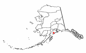
Fox River is a census-designated place (CDP) in Kenai Peninsula Borough, Alaska, United States. At the 2010 census the population was 685, up from 616 in 2000. It was first reported by the U.S. Geological Survey in 1895. The Fox River, which flows by the CDP, might have been named for Theodore Fox, a local mining magnate.

Easton is a census-designated place (CDP) in Fresno County, California, United States. The population was 2,083 at the 2010 census, up from 1,966 at the 2000 census. Easton is located 7.5 miles (12.1 km) south of downtown Fresno, at an elevation of 276 feet.

Shaver Lake is a census-designated place (CDP) in Fresno County, California, United States. The population was 634 at the 2010 census, down from 705 at the 2000 census. Shaver Lake is on the southwest end of the lake of the same name, 10 miles (16 km) east of New Auberry, at an elevation of 5,627 ft (1,715 m). The name honors C.B. Shaver, founder of the Fresno Flume and Irrigation Company that built the dam, creating the lake. The lake served as a mill pond for the Shaver Sawmill and the source for a flume that ran 42 miles (68 km) to Clovis, CA. The original town of Shaver was buried under the lake when the Thomas A. Edison Company purchased and enlarged the lake in 1919. l
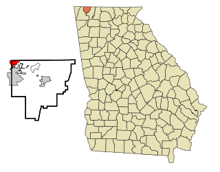
Lakeview is a census-designated place (CDP) in Catoosa and Walker counties in the U.S. state of Georgia. The population was 4,820 at the 2000 census and 4,839 at the 2010 census. It is part of the Chattanooga, TN–GA Metropolitan Statistical Area.

Haiku-Pauwela is a census-designated place (CDP) in Maui County, Hawaii, United States. The population was 8,118 at the 2010 census.

Lakes of the Four Seasons is a census-designated place (CDP) in Lake County and Porter County, in the U.S. state of Indiana. This private gated community's population was 7,033 at the 2010 census.

Middletown is an unincorporated community and census-designated place (CDP) in Shiawassee County in the U.S. state of Michigan. The CDP had a population of 897 at the 2010 census. Middletown is located within Caledonia Township along M-71 between the cities of Corunna and Owosso

Skidway Lake is an unincorporated community in Mills Township of Ogemaw County in the U.S. state of Michigan. It is a census-designated place (CDP) for statistical purposes but does not have any status as a separate municipal government. The population was 3,147 at the 2000 Census and 3,392 at the 2010 Census. Has post office Substation operated at Skidway Lake Rosati's

White Meadow Lake is an unincorporated community and census-designated place (CDP) located within Rockaway Township, in Morris County, New Jersey, United States. As of the 2010 United States Census, the CDP's population was 8,836.

Acomita Lake is a census-designated place (CDP) in Cibola County, New Mexico, United States. The population was 416 at the 2010 census.
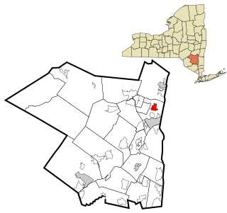
Lake Katrine is a hamlet in Ulster County, New York, United States. The population was 2,397 at the 2010 census.

Lake Darby is an unincorporated community and census-designated place in Franklin County, Ohio, United States, located mostly in Prairie Township and partly in Brown Township. It is more commonly known among locals as Darby Estates, which is also the name of the older housing development there, with the newer development called "West Point". As of the 2010 census, the CDP had a population of 4,592, up from 3,727 at the 2000 census.

Old Eucha is a census-designated place (CDP) in Delaware County, Oklahoma, United States. The population was 52 at the 2010 census.

Castanea is a census-designated place (CDP) in Castanea Township, Clinton County, Pennsylvania, United States. The population was 1,125 at the 2010 census.
Northwest Harborcreek is a census-designated place (CDP) in Erie County, Pennsylvania, United States. The population was 8,949 at the 2010 census. It includes the unincorporated communities of Fairfield and Brookside and is part of the Erie Metropolitan Statistical Area.

Yznaga is a census-designated place (CDP) in Cameron County, Texas, United States. The population was 91 at the 2010 census. It is part of the Brownsville–Harlingen Metropolitan Statistical Area.

Tainter Lake is a census-designated place (CDP) in part of the Town of Tainter, Dunn County, Wisconsin, and part of the Town of Red Cedar, Dunn County, Wisconsin, United States. The population was 2,242 at the 2010 census.

Rockport is a census-designated place (CDP) in the town of Rockport in Essex County, Massachusetts, United States. The population was 4,966 at the 2010 census.

Enfield is a census-designated place (CDP) and the main village in the town of Enfield in Grafton County, New Hampshire, United States. The population of the CDP was 1,540 at the 2010 census, out of 4,582 people in the entire town of Enfield.
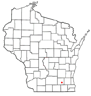
Hebron is a census-designated place (CDP) in the town of Hebron, Jefferson County, Wisconsin, United States. The population was 224 at the 2010 census. It is located on the Bark River.


