Lance Creek, Wyoming

Last updated
Lance Creek, Wyoming
CDP
Niobrara County Wyoming incorporated and unincorporated areas Lance Creek highlighted.svg
Location in Niobrara County and the state of Wyoming.
Usa edcp location map.svg
Red pog.svg
Lance Creek, Wyoming
Location in the United States
Coordinates: 43°2′44″N104°39′24″W / 43.04556°N 104.65667°W / 43.04556; -104.65667 Coordinates: 43°2′44″N104°39′24″W / 43.04556°N 104.65667°W / 43.04556; -104.65667
Country United States
State Wyoming
County Niobrara
Area
  Total42.0 sq mi (109 km2)
  Land41.9 sq mi (109 km2)
  Water0.01 sq mi (0.03 km2)
Elevation
4,475 ft (1,364 m)
Population
 (2020) [1]
  Total43
  Density1.0/sq mi (0.40/km2)
Time zone UTC-7 (Mountain (MST))
  Summer (DST) UTC-6 (MDT)
ZIP code
82222
Area code 307
FIPS code 56-44615 [2]
GNIS feature ID1590500 [3]

Lance Creek is a census-designated place (CDP) in Niobrara County, Wyoming, United States. The population was 43 at the 2010 census. Lance Creek is the namesake of the Lance Formation, a rock formation from the Late Cretaceous that has yielded fossils from a diverse number of species.

Contents

Geography

Lance Creek is located at 43°2′44″N104°39′24″W / 43.04556°N 104.65667°W / 43.04556; -104.65667 (43.045452, -104.656628). [4]

According to the United States Census Bureau, the CDP has a total area of 42.0 square miles (108.8 km2), of which 42.0 square miles (108.8 km2) is land and 0.026% is water. [5]

Demographics

At the 2000 census, [2] there were 51 people, 21 households and 17 families residing in the CDP. The population density was 1.2 per square mile (0.5/km2). There were 53 housing units at an average density of 1.3/sq mi (0.5/km2). The racial makeup of the CDP was 96.08% White, and 3.92% from two or more races. Hispanic or Latino of any race were 3.92% of the population.

There were 21 households, of which 19.0% had children under the age of 18 living with them, 76.2% were married couples living together, 4.8% had a female householder with no husband present, and 14.3% were non-families. 4.8% of all households were made up of individuals, and none had someone living alone who was 65 years of age or older. The average household size was 2.43 and the average family size was 2.56.

17.6% of the population were under the age of 18, 2.0% from 18 to 24, 21.6% from 25 to 44, 37.3% from 45 to 64, and 21.6% who were 65 years of age or older. The median age was 49 years. For every 100 females, there were 104.0 males. For every 100 females age 18 and over, there were 100.0 males.

The median household income was $36,250 and the median family income was $36,250. Males had a median income of $26,875 versus $16,250 for females. The per capita income for the CDP was $14,419. None of the population or the families were below the poverty line.

Education

Public education in Lance Creek is provided by Niobrara County School District #1. Schools serving the community include Lance Creek School (grades K-3), Lusk Elementary/Middle School (grades K-6), Niobrara County High School (grades 7-12).

Highways

Related Research Articles

<span class="mw-page-title-main">Niobrara County, Wyoming</span> County in Wyoming, United States

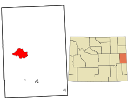
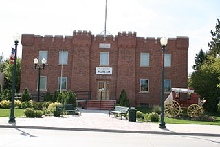
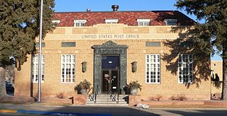
Niobrara County is a county in the U.S. state of Wyoming. As of the 2020 United States Census, the population was 2,467, making it the least populous county in Wyoming. Its county seat is Lusk. Its eastern boundary abuts the west lines of the states of Nebraska and South Dakota.

<span class="mw-page-title-main">Goshen County, Wyoming</span> County in Wyoming, United States

Goshen County is a county in the U.S. state of Wyoming. As of the 2020 United States Census, the population was 12,498. Its county seat is Torrington. The eastern boundary of the County borders the Nebraska state line.

<span class="mw-page-title-main">Portage Creek, Alaska</span> Census-designated place in Alaska, United States

Portage Creek is a census-designated place (CDP) in Dillingham Census Area, Alaska, United States. The population was 2 at the 2010 census, down from 36 at the 2000 census.

<span class="mw-page-title-main">Fritz Creek, Alaska</span> Census-designated place in Alaska, United States

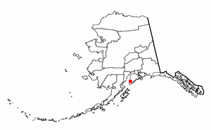
Fritz Creek is a census-designated place (CDP) in the Kenai Peninsula Borough, Alaska, United States, northeast of Homer. At the 2020 census the population was 2,248, up from 1,932 in 2010.

Birch Creek is a census-designated place (CDP) in Yukon-Koyukuk Census Area, Alaska, United States. The population was 33 at the 2010 census, up from 28 in 2000.

<span class="mw-page-title-main">Shaver Lake, California</span> Census-designated place in California, United States

Shaver Lake is a census-designated place (CDP) in Fresno County, California, United States. The population was 634 at the 2010 census, down from 705 at the 2000 census. Shaver Lake is on the southwest end of the lake of the same name, 10 miles (16 km) east of New Auberry, at an elevation of 5,627 ft (1,715 m). The name honors C.B. Shaver, founder of the Fresno Flume and Irrigation Company that built the dam, creating the lake. The lake served as a mill pond for the Shaver Sawmill and the source for a flume that ran 65 miles (105 km) to Clovis. The original town of Shaver was buried under the lake when the Thomas A. Edison Company purchased and enlarged the lake in 1919.

<span class="mw-page-title-main">Coram, Montana</span> Unincorporated community in Montana, United States

Coram is an unincorporated community and census-designated place (CDP) in Flathead County, Montana, United States. The population was 539 in 2010, up from 337 at the 2000 census. Coram lies 7 miles (11 km) southwest of the western entrance of Glacier National Park.

<span class="mw-page-title-main">Herron, Montana</span> Census-designated place in Montana, United States

Herron is a census-designated place (CDP) in Hill County, Montana, United States. The population was 43 at the 2010 census.

<span class="mw-page-title-main">Blue Diamond, Nevada</span> Census-designated place in Clark County, Nevada, United States

Blue Diamond is a census-designated place (CDP) in Clark County, Nevada, United States. The population was 268 at the 2020 census.

<span class="mw-page-title-main">Vancleave, Mississippi</span> Census-designated place in Mississippi

Vancleave is an unincorporated community and census-designated place (CDP) in Jackson County, Mississippi, United States. It is part of the Pascagoula Metropolitan Statistical Area. The population was 5,886 at the 2010 census, up from 4,910 at the 2000 census.

<span class="mw-page-title-main">Bent Creek, Buncombe County, North Carolina</span> Census-designated place in North Carolina, United States

Bent Creek is a census-designated place (CDP) in Buncombe County, North Carolina, United States. The population was 1,287 at the 2010 census. The Bent Creek area has mountain bike trails within the Pisgah National Forest.

<span class="mw-page-title-main">Beaver, Oregon</span> Unincorporated community in the state of Oregon, United States

Beaver is an unincorporated community in Tillamook County, Oregon, United States, along U.S. Route 101 and the Nestucca River, about 12 miles (19 km) south of Tillamook. For statistical purposes, the United States Census Bureau has defined Beaver as a census-designated place (CDP). The census definition of the area may not precisely correspond to local understanding of the area with the same name. The population of the CDP was 122 at the 2010 census.

<span class="mw-page-title-main">Spring Creek, South Dakota</span> CDP in South Dakota, United States

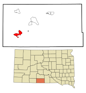
Spring Creek is a census-designated place (CDP) in Todd County, South Dakota, United States. The population was 236 at the 2020 census.

<span class="mw-page-title-main">Hawk Springs, Wyoming</span> CDP in Wyoming, United States

Hawk Springs is a census-designated place (CDP) in Goshen County, Wyoming, United States. The population was 45 at the 2010 census.

<span class="mw-page-title-main">Huntley, Wyoming</span> CDP in Wyoming, United States

Huntley is a census-designated place (CDP) in Goshen County, Wyoming, United States. The population was 30 at the 2010 census.

<span class="mw-page-title-main">Manville, Wyoming</span> Town in Wyoming, United States

Manville is a town in Niobrara County, Wyoming, United States. The population was 95 at the 2010 census.

<span class="mw-page-title-main">Van Tassell, Wyoming</span> Town in Wyoming, United States

Van Tassell is a town in Niobrara County, Wyoming, United States. The population was 15 at the 2010 census. It is the least populous town in the least populous county of the least populous state in the U.S.

<span class="mw-page-title-main">Lakeview North, Wyoming</span> CDP in Wyoming, United States

Lakeview North is a census-designated place (CDP) in Platte County, Wyoming, United States. The population was 84 at the 2010 census.

<span class="mw-page-title-main">Wilson, Wyoming</span> CDP in Wyoming, United States

Wilson is a census-designated place (CDP) in Teton County, Wyoming, United States. The population was 1,567 at the 2020 census, up from 1,482 in 2010. It is part of the Jackson, WY–ID Micropolitan Statistical Area.

<span class="mw-page-title-main">Osage, Wyoming</span> CDP in Wyoming, United States

Osage is a census-designated place (CDP) in Weston County, Wyoming, United States. The population was 151 at the 2020 census.

References

  1. "2010 City Population and Housing Occupancy Status". U.S. Census Bureau. Retrieved July 13, 2012.[ dead link ]
  2. 1 2 "U.S. Census website". United States Census Bureau . Retrieved 2008-01-31.
  3. "US Board on Geographic Names". United States Geological Survey. 2007-10-25. Retrieved 2008-01-31.
  4. "US Gazetteer files: 2010, 2000, and 1990". United States Census Bureau. 2011-02-12. Retrieved 2011-04-23.
  5. "2010 Wyoming Place Names". U.S. Census Bureau. Archived from the original on April 11, 2011. Retrieved July 13, 2012.