Fair Oaks is a census-designated place (CDP) in Sacramento County, California, United States. It is part of the Sacramento–Arden-Arcade–Roseville Metropolitan Statistical Area. The population was 32,514 at the 2020 census, up from 30,912 at the 2010 census. The Fair Oaks zip code is 95628 and its area codes are 916 and 279. It is bordered to the west by Carmichael, north by the city of Citrus Heights, to the east by Orangevale, and to the south by the American River.

Parkway–South Sacramento is a former census-designated place (CDP) in Sacramento County, California, United States. It is part of the Sacramento–Arden-Arcade–Roseville Metropolitan Statistical Area. The area shares three boundaries with the City of Sacramento. The population was 36,468 at the 2000 census.

Pocket-Greenhaven is a suburban community within the city of Sacramento, California, 5 miles south of downtown Sacramento. It is bordered by Interstate 5 on the east and a semi-circular "pocket" bend in the Sacramento River on the south, west, and north. The three exits into the Pocket-Greenhaven community off Interstate 5 are 43rd Avenue, Florin Road, and Pocket/Meadowview Road. Entering the area from the South on Interstate 5, travelers pass a landmark water tower with the words "Welcome to SACRAMENTO AMERICA'S FARM-TO-FORK CAPITAL" painted on it, marking the southern boundary of the city of Sacramento. The water tower was originally blank and looked very much like a spaceship alongside wheat and barley fields. Pocket-Greenhaven is located in the 95831 Zipcode.

Montclair is a hillside neighborhood in Oakland, California, United States. Montclair is located along the western slope of the Oakland Hills from a valley formed by the Hayward Fault to the upper ridge of the hills.
California's 7th congressional district is a United States congressional district in California. Doris Matsui, a Democrat, has represented the district since January 2023.
East Sacramento is a neighborhood in Sacramento, California, United States, that is east of downtown and midtown. East Sacramento is bounded by U.S. Route 50 to the south, Business Loop 80 to the west and north, Elvas Avenue to the northeast and east, and California State University, Sacramento and the American River to the southeast. East Sacramento residential development began in the 1890s, and the area was annexed into Sacramento in 1911. East Sacramento was also home to the Alhambra Theatre. East Sacramento also includes McKinley Park and the "Fabulous Forties" neighborhood.
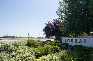
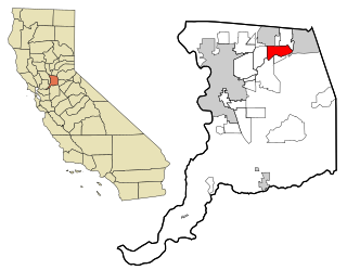
Natomas is a community in the northwestern section of the city of Sacramento, in the U.S. state of California.
Del Paso Heights is a neighborhood within the city of Sacramento in Sacramento County, California, United States. The generally recognized borders of Del Paso Heights consist of the Beltline Freeway Interstate 80 on the north, Norwood Avenue on the west, Arcade Creek on the south, and Roseville Road on the east. Del Paso Heights is located in Area 4 of Sacramento which is defined as the city north of the American River.

The Sacramento City Council is the governing body of the city of Sacramento, California. The council holds regular meetings at Sacramento City Hall on Tuesdays at 6:00 pm, with exceptions for holidays and other special cases.

Curtis Park is a neighborhood located within the city of Sacramento, California. Curtis Park is defined as north of Sutterville Road, south of Broadway, east of Freeport Boulevard, and west of Highway 99. Curtis Park is a largely residential neighborhood. It is known for its charming vintage homes including Victorian, Bungalow, and 1920s revival style subdivisions. Information about the neighborhood can be obtained from the Sierra Curtis Neighborhood Association.
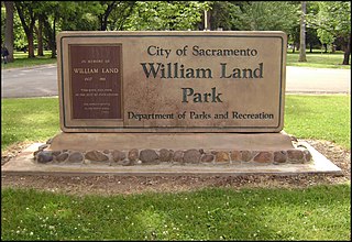
William Land Park, frequently referred to as simply "Land Park" is a major city park in Sacramento, California. The park is located between Interstate 5 and State Route 160.
Upper Land Park is a neighborhood in the more general Land Park area of Sacramento, California which is referred to by the city as Area 2. It is located near the junction of U.S. Route 50 and Interstate 5. Its boundaries are officially Broadway to the north, Swanston Drive to the south, Riverside Boulevard to the east, and I-5 to the west.

Tahoe Park is a neighborhood located within the city of Sacramento, California.
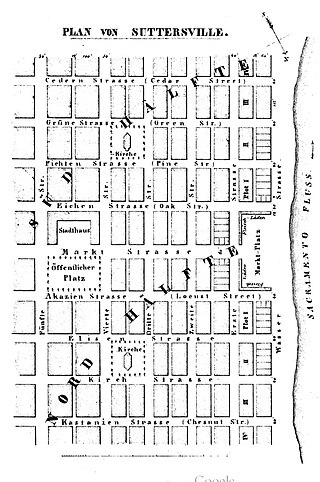
Sutterville is a former settlement in Sacramento County, California. It was located on the Southern Pacific Railroad 2.25 miles (3.6 km) south-southwest of Sacramento,
There are 21 routes assigned to the "E" zone of the California Route Marker Program, which designates county routes in California. The "E" zone includes county highways in Alpine, Amador, Butte, Calaveras, El Dorado, Placer, Plumas, Sacramento, Solano, Tuolumne, Yolo, and Yuba counties.
Ocean View Hills is a residential neighborhood in the southern section of San Diego. It borders Interstate 805 to the west and California State Route 905 to the south. It neighbors Otay Mesa to the south and east, Otay Mesa West to the west and Chula Vista to the north. Major thoroughfares include Dennery Road, Otay Mesa Road, Del Sol Blvd and Ocean View Hills Parkway.
Southeast Village is a neighborhood located in Southeast Sacramento. Its boundaries are Lemon Hill Ave to the north, 65th St. Expy to the west, 53rd Ave to the south, along with Logan St and 75th St to the east.

The Zombie Hut was a Hawaiian/Polynesian-themed restaurant, nightclub and Tiki bar located on Freeport Blvd. between Florin Road and Sutterville Road in Sacramento, California that originally opened in 1945 after the end of WWII and continuing for 45 years until its closing in 1990. Inspired by the 1930s Tiki craze, the restaurant was owned by Johnny Quaresma from 1945 to 1952 when Ed and Beatrice Hill purchased the business. The Hills eventually sold the Zombie Hut to Bruce Brooks, who owned it until its closing in 1990.

Transportation in the Sacramento metropolitan area consists of a variety of modes of travel in El Dorado County, Placer County, Sacramento County, and Yolo County, which are the four counties that comprise the Sacramento metropolitan area.

Western Hotel, was an historical hotel in Sacramento, California. The site of the former hotel is an California Historical Landmark No. 601 listed on May 22, 1957. The Western Hotel was at/near the intersection of 2nd street and K Street, Sacramento and owned by William Land. The site is now a Parking lot under the Interstate 5 in California.
