Related Research Articles

Sutter's Fort was a 19th-century agricultural and trade colony in the Mexican Alta California province. Established in 1839, the site of the fort was originally called New Helvetia by its builder John Sutter, though construction of the fort proper would not begin until 1841. The fort was the first non-indigenous community in the California Central Valley. The fort is famous for its association with the Donner Party, the California Gold Rush, and the formation of the city of Sacramento, surrounding the fort. It is notable for its proximity to the end of the California Trail and Siskiyou Trails, which it served as a waystation.

The Los Rios Community College District is a special-purpose district providing administrative services and governance for the community colleges serving the greater Sacramento area and points east all the way to Lake Tahoe.
The Alhambra Theatre opened in 1927 and was the preeminent movie house in the greater Sacramento area for many years. It was designed in the Moorish style of the great Spanish cities and included a large courtyard and fountain. The interior was lavishly appointed with red carpet, gold trim, and large pillars. It was located directly beyond the eastern terminus of K Street at 1025 Thirty-First Street, now Alhambra Boulevard, Sacramento, California 95816, in the East Sacramento neighborhood.
Elmhurst is a historic residential neighborhood located in the eastern part of Sacramento, California. Elmhurst is known for its large elm, ash, and oak trees that provide shady canopy for the neighborhood.

Area codes 209 and 350 are telephone area codes in the North American Numbering Plan (NANP) for the U.S. state of California. Their service area includes Stockton, Modesto, Turlock, Merced, Winton, Atwater, Livingston, Manteca, Ripon, Tracy, Lodi, Galt, Sonora, Los Banos, San Andreas, Mariposa, and Yosemite, the northern San Joaquin Valley, and the Sierra Foothills.
East Sacramento is a neighborhood in Sacramento, California, United States, that is east of downtown and midtown. East Sacramento is bounded by U.S. Route 50 to the south, Business Loop 80 to the west and north, Elvas Avenue to the northeast and east, and California State University, Sacramento and the American River to the southeast. East Sacramento residential development began in the 1890s, and the area was annexed into Sacramento in 1911. East Sacramento was also home to the Alhambra Theatre. East Sacramento also includes McKinley Park and the "Fabulous Forties" neighborhood.
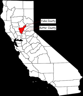
The Yuba–Sutter area, or Yuba City Metropolitan Statistical Area, is a smaller metropolitan community including Yuba and Sutter Counties in Northern California's Central Valley within the Greater Sacramento area.
Del Paso Heights is a neighborhood within the city of Sacramento in Sacramento County, California, United States. The generally recognized borders of Del Paso Heights consist of the Beltline Freeway Interstate 80 on the north, Norwood Avenue on the west, Arcade Creek on the south, and Roseville Road on the east. Del Paso Heights is located in Area 4 of Sacramento which is defined as the city north of the American River.
Robla is a neighborhood located within the city of Sacramento, California, United States. The borders of Robla are generally considered to be city limits on the north adjacent to Rio Linda, McClellan Park on the east, the Beltline Freeway Interstate 80 on the south, and Northgate Boulevard on the west. Robla was part of the "Unincorporated place" of Del Paso Heights-Robla, which recorded a population of 11,495 in 1960.
Ben Ali is a neighborhood located within the city of Sacramento, California, United States. According to The Ben Ali Community Association, the boundaries of the neighborhood are:
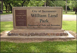
William Land Park, frequently referred to as simply "Land Park" is a major city park in Sacramento, California. The park is located between Interstate 5 and State Route 160.
Midtown Sacramento is a historical district and neighborhood just east of Downtown Sacramento. Officially, Midtown's borders are R Street on the South, J Street on the North, 16th Street on the West and 30th Street on the East. However, the streets in Sacramento's original "grid" that are east of 16th Street cover the area commonly called "Midtown". This more general definition covers an area bounded by Broadway on the South, C street and the Southern Pacific rail lines on the North, 16th Street on the West and Alhambra Boulevard on the East.
North Sacramento is a well-established community that is part of the city of Sacramento, California, United States. It was a city from its incorporation in 1924 until it was merged in 1964 into the City of Sacramento. Incorporation was led by the North Sacramento Chamber of Commerce, incorporated the year before, in 1923.
Upper Land Park is a neighborhood in the more general Land Park area of Sacramento, California which is referred to by the city as Area 2. It is located near the junction of U.S. Route 50 and Interstate 5. Its boundaries are officially Broadway to the north, Swanston Drive to the south, Riverside Boulevard to the east, and I-5 to the west.

Emma Prusch Farm Park is a 43.5 acre park in East San Jose, California. Donated by Emma Prusch to the City of San Jose in 1962 to use to demonstrate the valley's agricultural past, it includes a 4-H barn, community gardens, a rare-fruit orchard, demonstration gardens, picnic areas, and expanses of lawn. The park is host to an annual Harvest Festival and is operated cooperatively by the San Jose Parks and Recreation Department and the non-profit Emma Prusch Farm Park Foundation.
Swanston Estates is a neighborhood situated in North Sacramento, California. It is bordered by Arden Way on the south, Ethan Way on the East, Business 80 on the west, and El Camino Avenue on the north. This area lies behind the Arden Fair Mall. The zip code for the neighborhood is 95815.

The California State Fair (CSF) is the annual state fair for the state of California. The fair is held at Cal Expo in Sacramento, California. The Fair is a 17-day event showcasing California's industries, agriculture, and diversity of people. The CSF features blue-ribbon animal displays, culinary delights and competitions, live music concerts, a carnival, fireworks, and other family fun. In 2018, officials reported daily attendance drew between 20,000 and 60,000 people per day and about $8.5 million of food and beverage expenditures. The fair is policed by the California Exposition and State Fair Police.
Southeast Village is a neighborhood located in Southeast Sacramento. Its boundaries are Lemon Hill Ave to the north, 65th St. Expy to the west, 53rd Ave to the south, along with Logan St and 75th St to the east.

Fremont Weir Wildlife Area is 1,461 acres (591 ha) at the north end of the Yolo Bypass floodway along the Sacramento River in Sutter County and Yolo County. It is 6 miles north-east of the city of Woodland and 15 miles north of Yolo Bypass Wildlife Area and the nearby Sacramento Bypass Wildlife Area. Whenever water in the river exceeds the height of the weir the excess flow runs over the weir and down the Yolo Bypass floodway, thereby reducing the risks of flooding in the city of Sacramento and nearby urban areas along the river.

Dead Horse Island is a 230-acre private island in the San Joaquin River delta, in California. It is located in Sacramento County, owned by the Wilson Family and managed by Reclamation District 2111. Its coordinates are 38.2290821°N 121.5021750°W.
References
- ↑ Billingley, Mark (August 18, 1994). "Valley View Acres: No place like most homes". The Sacramento Bee. page 117 and page 121 RetrievedJuly 23, 2023.
- ↑ "9.44.340 Keeping of livestock in the city". Sacramento, California City Code. Quality Code Publlishing. 1 August 2023. Retrieved September 28, 2023.
38°40′06″N121°29′03″W / 38.6682°N 121.4842°W

| | This Sacramento County, California-related article is a stub. You can help Wikipedia by expanding it. |