
Sutter's Fort was a 19th-century agricultural and trade colony in the Mexican Alta California province. Established in 1839, the site of the fort was originally called New Helvetia by its builder John Sutter, though construction of the fort proper would not begin until 1841. The fort was the first non-indigenous community in the California Central Valley. The fort is famous for its association with the Donner Party, the California Gold Rush, and the formation of the city of Sacramento, surrounding the fort. It is notable for its proximity to the end of the California Trail and Siskiyou Trails, which it served as a waystation.

Arden-Arcade is a census-designated place (CDP) in Sacramento County, California, United States. The population was 94,659 at the 2020 census, making it the second most populous census-designated place in California. It is east of the city of Sacramento and west of the community of Carmichael.

The Los Rios Community College District is a special-purpose district providing administrative services and governance for the community colleges serving the greater Sacramento area and points east all the way to Lake Tahoe.
Elmhurst is a historic residential neighborhood located in the eastern part of Sacramento, California. Elmhurst is known for its large elm, ash, and oak trees that provide shady canopy for the neighborhood.

Arthur A. Benjamin Health Professions High School (AABHPHS) is a high school in the Upper Land Park neighborhood of Sacramento, California. A member of the Sacramento City Unified School District.
East Sacramento is a neighborhood in Sacramento, California, United States, that is east of downtown and midtown. East Sacramento is bounded by U.S. Route 50 to the south, Business Loop 80 to the west and north, Elvas Avenue to the northeast and east, and California State University, Sacramento and the American River to the southeast. East Sacramento residential development began in the 1890s, and the area was annexed into Sacramento in 1911. East Sacramento was also home to the Alhambra Theatre. East Sacramento also includes McKinley Park and the "Fabulous Forties" neighborhood.
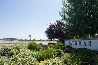
Natomas is a community in the northwestern section of the city of Sacramento, in the U.S. state of California.
Del Paso Heights is a neighborhood within the city of Sacramento in Sacramento County, California, United States. The generally recognized borders of Del Paso Heights consist of the Beltline Freeway Interstate 80 on the north, Norwood Avenue on the west, Arcade Creek on the south, and Roseville Road on the east. Del Paso Heights is located in Area 4 of Sacramento which is defined as the city north of the American River.
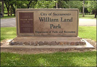
William Land Park, frequently referred to as simply "Land Park" is a major city park in Sacramento, California. The park is located between Interstate 5 and State Route 160.
Gardenland is a neighborhood in the city of Sacramento, California, around the Natomas Basin. It borders Northgate Boulevard to the west, Indiana Avenue to the north, Steelhead Creek to the east, and the Arden-Garden Connector to the south. It is the richest agricultural area within city limits.
New Era Park is a neighborhood in Sacramento, California. Its southern border is the middle of E Street, the American River is its northern border while 29th Street and 16th Street serve as eastern and western borders of the district. The majority of the area of Sutter's Landing Park sits inside the New Era neighborhood. As of 2007, the park contains some pedestrian trails and a skateboard park inside the old recycling plant, but is for the most part unimproved. Eventually the city plans on siting a number of sports fields and multiuse spaces within the park, and will connect it to the American River bicycle and running path to the west once rights-of-way with Blue Diamond and other industrial neighbors can be worked out.
Land Park is a neighborhood in the city of Sacramento. Land Park consists of mainly single-family dwellings in the area between Interstate 5 to the west, Broadway to the north, Sutterville Road to the south and Freeport Blvd to the east. William Land Park is its namesake, a major city park south of Highway 50 and east of Interstate 5 in South Sacramento. It also contains the Sacramento Zoo along with the popular children's theme parks Funderland and Fairy Tale Town. In addition, Land Park is the home to the popular Vic's Ice Cream, Masullo Pizza, Tower Cafe, and Tower Theater. Katie Valenzuela is the city councilmember for District 4, which includes the entire Land Park area.
North Sacramento is a well-established community that is part of the city of Sacramento, California, United States. It was a city from its incorporation in 1924 until it was merged in 1964 into the City of Sacramento. Incorporation was led by the North Sacramento Chamber of Commerce, incorporated the year before, in 1923.

The California Governor's Mansion is the official residence of the governor of California, located in Sacramento, the capital of California. Built in 1877, the estate was purchased by the Californian government in 1903 and has served as the executive residence for 14 governors. The mansion was occupied by governors between 1903–1967 and 2015–2019. Since 1967, the mansion has been managed by California State Parks as the Governor's Mansion State Historic Park.
Swanston Estates is a neighborhood situated in North Sacramento, California. It is bordered by Arden Way on the south, Ethan Way on the East, Business 80 on the west, and El Camino Avenue on the north. This area lies behind the Arden Fair Mall. The zip code for the neighborhood is 95815.
Southside Park is a neighborhood in Sacramento, California, located immediately south of Downtown Sacramento. Its official borders are R Street to the north, W-X Freeway to the south, I-5 to the west, and 12th Street to the east.
Southeast Village is a neighborhood located in Southeast Sacramento. Its boundaries are Lemon Hill Ave to the north, 65th St. Expy to the west, 53rd Ave to the south, along with Logan St and 75th St to the east.

Fremont Weir Wildlife Area is 1,461 acres (591 ha) at the north end of the Yolo Bypass floodway along the Sacramento River in Sutter County and Yolo County. It is 6 miles north-east of the city of Woodland and 15 miles north of Yolo Bypass Wildlife Area and the nearby Sacramento Bypass Wildlife Area. Whenever water in the river exceeds the height of the weir the excess flow runs over the weir and down the Yolo Bypass floodway, thereby reducing the risks of flooding in the city of Sacramento and nearby urban areas along the river.

Little Mandeville Island is a small, mostly submerged island in the San Joaquin River delta, in California. It is part of San Joaquin County, and its coordinates are 38.0104776°N 121.5649522°W. In 1994, 376 acres (152 ha) of former farmland was inundated with water after a levee broke.
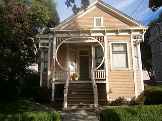
The Alkali Flat Historic District is a historic district in Sacramento, California. It is the oldest surviving neighborhood in Sacramento. The older Alkali Flat buildings and homes were built between 1853 and 1869 by the Sacramento's upper class. Alkali Flat borders are: 12th Street, H Street, 7th Street, and Southern Pacific Train tracks to the north.
