Lasauses, Colorado

Last updated

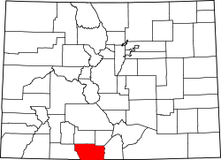
Los Sauces is a populated place in Conejos County, Colorado, United States, [1] on the west side of the Rio Grande.

Variant names of the community listed in the Geographic Names Information System are La Sauses, Los Sauces, and Los Sauses. [1]

A sign along State Highway 142 indicating a turnoff for the community Distance road sign for Los Sauces.JPG
A sign along State Highway 142 indicating a turnoff for the community

The community came into being in the 1847 as a ford where stagecoaches and other wagons crossed the Rio Grande. Though small, it contained a store, dancehall, and a post office from 1895 to 1920. [2] In 1941 (then population 150), it was written that the community was settled by Antonio Marquez, Jose Rodriques, and Fernando Borrego in 1863–64, and was called "Los Sauses," which is Spanish for "willows," and named after the trees along the river and lagoons that look like that tree. The name was intended to be "Los Sauses" but became "La Sauses" on a post office application, and the error was never fixed. [3]

Despite the incorrect spelling, people from the region still refer to the town by the correct name, Los Sauces, and some highway signage has been changed to reflect the correct spelling of the town's name.

The adobe church La Capilla de San Antonio de Padua, first constructed in 1880, and replaced in 1928, is located in the community, and is listed in the Colorado State Register of Historic Properties. [4] [5]

Location

Related Research Articles

<span class="mw-page-title-main">Conejos County, Colorado</span> County in Colorado, United States

Conejos County is a county located in the U.S. state of Colorado. As of the 2020 census, the population was 7,461. The county seat is the unincorporated community of Conejos.

Isthmus Nahuatl is a Nahuatl dialect cluster spoken by about 30,000 people in Veracruz, Mexico. According to Ethnologue 16, the Cosoleacaque dialect is 84% intelligible with Pajapan, and 83% intelligible with Mecayapan.

<span class="mw-page-title-main">Rocky Comfort, Missouri</span> Census-Designated Place in Missouri, United States

Rocky Comfort is an unincorporated community and census-designated place in northeastern McDonald County, Missouri, United States, on Route 76. It is part of the Fayetteville–Springdale–Rogers, AR-MO Metropolitan Statistical Area.

<span class="mw-page-title-main">Villa Grove, Colorado</span> Unincorporated community in Colorado, United States

Villa Grove is an unincorporated community and a U.S. Post Office in Saguache County, Colorado, United States. The Villa Grove Post Office has the ZIP Code 81155.

<span class="mw-page-title-main">Monción</span> Place in Santiago Rodríguez, Dominican Republic

Monción is one of the 3 municipalities of the province in Santiago Rodriguez, Dominican Republic.

<span class="mw-page-title-main">Tlaxiaco</span> City in Oaxaca, Mexico

Tlaxiaco is a city, and its surrounding municipality of the same name, in the Mexican state of Oaxaca. It is located in the Tlaxiaco District in the south of the Mixteca Region, with a population of about 17,450.

Wilders is an unincorporated community in Dewey Township, LaPorte County, Indiana.

<span class="mw-page-title-main">Rio Grande Scenic Railroad</span> Train line in Colorado and New Mexico

The Rio Grande Scenic Railroad of Colorado was a heritage railway that operated from 2006 to 2019 in and around the San Luis Valley as a subsidiary of the San Luis and Rio Grande Railroad. The heritage railroad ceased operating excursions following a wildfire that damaged some of their facilities, as well as the parent company SLRG entering Chapter 11 bankruptcy in late 2019.

<span class="mw-page-title-main">Montague Island (Baja California)</span> Island in Baja California, Mexico

Montague Island, known in Spanish as Isla Montague, is an island at the mouth of the Colorado River in the municipality of Mexicali, Baja California, Mexico, and is part of the Colorado River Delta and part of a broader region called the Salton Trough. It is about 32 km (20 mi) in length along its longest axis.

Cobham Park is an unincorporated community in Richmond County, in the U.S. state of Virginia.

<span class="mw-page-title-main">Tres Piedras, New Mexico</span>

Tres Piedras is an unincorporated community in Taos County, northern New Mexico, United States, adjacent to Carson National Forest.

<span class="mw-page-title-main">Bountiful, Colorado</span> Unincorporated community in Colorado, U.S.

Bountiful is an unincorporated community in Conejos County, in the U.S. state of Colorado.

Cherry Valley is an unincorporated community in Crawford County, in the U.S. state of Missouri.

Short Bend is an unincorporated community in Dent County, in the U.S. state of Missouri.

Round Grove is an unincorporated community in Lawrence County, in the U.S. state of Missouri.

Dry Fork is a stream in Polk County in the U.S. state of Missouri. It is a tributary of the Pomme de Terre River.

<span class="mw-page-title-main">San Luis Hills</span>

The San Luis Hills are a group of small mountain ranges in Conejos and Costilla counties in the San Luis Valley in southern Colorado. The individual mountain ranges that make up the San Luis Hills include the Fairy Hills, the Brownie Hills, the Piñon Hills, and the South Piñon Hills. The San Luis Hills' highest point is Flat Top, elevation 9,206 feet

References

  1. 1 2 "Lasauses". Geographic Names Information System . United States Geological Survey, United States Department of the Interior.
  2. Simmons, Virginia (17 November 2009). Preserving Los Sauces area Archived 2016-09-24 at the Wayback Machine , Valley Courier
  3. Place Names In Colorado (L), Colorado Magazine p. 231 (Vol. 18, No. 6, November 1941) (taken from Federal Writers' Project) "Archived copy" (PDF). Archived from the original on April 20, 2016. Retrieved May 31, 2016.{{cite web}}: CS1 maint: archived copy as title (link) CS1 maint: bot: original URL status unknown (link)
  4. Noel, Thomas J. Guide to Colorado Historic Places, p. 263 (2007)
  5. "La Capilla De San Antonio De Padua". History Colorado. 2022. Retrieved November 20, 2011.

37°16′00″N105°44′47″W / 37.26667°N 105.74639°W / 37.26667; -105.74639