Manassa's elevation is 7,683 feet (2,342m) above sea level. The land within Manassa city limits is entirely flat, with rolling hills nearby. Foothills and mountains (taller than 14,000 feet (4,300m)) are farther in each direction, including the Sangre de Cristo Range to the east and the San Juan Mountains to the west.
The San Luis Valley contains six counties and portions of three others. It is an extensive high-elevation depositional basin of approximately 8,000 square miles (21,000km2) with an average elevation of 7,664 feet (2,336m) above sea level. The valley is a section of the Rio Grande Rift and is drained to the south by the Rio Grande, which rises in the San Juan Mountains to the west of the valley and flows south into New Mexico. The San Luis Valley has a cold desert climate but has substantial water resources from the Rio Grande and groundwater.
History
Migration patterns demonstrate how people from northern New Mexico settled the area around Manassa in the mid 19th century. Many early settlers were the descendants of colonists from the Spanish colonial period beginning in 1598 with Juan de Oñate's colonization of New Mexico. Today, approximately half of Manassa's residents are of Spanish and Mexican heritage. Most of the other citizens of Manassa are the descendants of the Mormon pioneers who founded Manassa in 1879, and named the town after Manasseh,[7] a son of the Israelite Joseph. Manassa was located a short distance from two ranches purchased by the Mormons from Hispanos on the south side of the Conejos River, across from Los Cerritos, Colorado.
The selection of the land for the colony was made on the assurance that the railroad would soon be built nearby. However, one year later the railroad bypassed the colony, and instead passed through Romeo, Colorado, just three miles to the west.
Railroad
The selection of the land for the colony was made on the assurance that the railroad would soon be built nearby. However, one year later the railroad bypassed the colony, and instead passed through Romeo, just 3 miles (5km) to the west.[8]
As of the census[12] of 2000, there were 1,042 people, 362 households, and 280 families residing in the town. The population density was 1,110.9 inhabitants per square mile (428.9/km2). There were 398 housing units at an average density of 424.3 unitsper square mile (163.8 units/km2). The racial makeup of the town was 81.00% White, 0.48% African American, 1.63% Native American, 0.10% Asian, 0.19% Pacific Islander, 13.24% from other races, and 3.36% from two or more races. Hispanic or Latino of any race were 48.75% of the population.
There were 362 households, out of which 41.2% had children under the age of 18 living with them, 59.1% were married couples living together, 13.5% had a female householder with no husband present, and 22.4% were non-families. 20.7% of all households were made up of individuals, and 9.1% had someone living alone who was 65 years of age or older. The average household size was 2.88 and the average family size was 3.33.
In the town, the population was spread out, with 33.7% under the age of 18, 9.4% from 18 to 24, 22.9% from 25 to 44, 20.3% from 45 to 64, and 13.6% who were 65 years of age or older. The median age was 31 years. For every 100 females, there were 95.9 males. For every 100 females age 18 and over, there were 97.4 males.
The median income for a household in the town was $23,092, and the median income for a family was $26,827. Males had a median income of $23,295 versus $16,029 for females. The per capita income for the town was $12,576. About 23.2% of families and 28.6% of the population were below the poverty line, including 40.8% of those under age 18 and 19.4% of those age 65 or over.
Streets
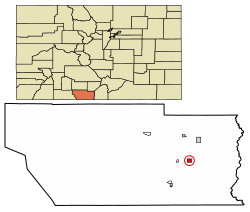
Satellite photograph showing the layout of Manassa's streets. Farmland and ranches abound in all directions, giving way to foothills and high mountains.
Manassa's wide streets, such as those typically found elsewhere in towns started by Mormons, are fashioned in a grid system.[13] The town fits perfectly in a township and comprises close to one square mile, made up of eight blocks by eight blocks for a total of 64 city blocks. From east to west, the streets are numbered First through Ninth. From south to north, the streets are named South, Jack, Morgan, Smith, Main (aka State Highway 142), Berthelson, Peterson, Dotson, and North.
Manassa's mile-long Main Street is designated State Highway 142, connecting Romeo and U.S. Route 2853 miles (5km) to the west, with the historic town of San Luis in Costilla County29 miles (47km) to the east. The San Luis Hills are east of Manassa, on State Highway 142, between Manassa and San Luis.
The community-at-large, and generations from all over the San Luis Valley and beyond, celebrate Manassa Pioneer Days[14] with a colorful parade known for its amazing floats goes down Main Street on two days. At the fairgrounds you can watch horse races, rodeo events, motocross races, a very popular demolition derby, fireworks, live entertainment, barbecues, and a morning 5K run.
This is one of the best western heritage festivals around, and it includes a carnival with the Tilt-a-Whirl, bumper cars, ferris wheel, a merry-go-round, and other midway rides. Live musical entertainment, a hamburger stand, and vendor booths line Manassa's city park on Main Street during these busy days. The rocks on the nearby mountain with its painted letter M are doused with kerosene and the burning spectacle lights up the night sky for several hours.
The celebration features small-town fun and more than a century of tradition. Held annually for two days around July 24, this is one of the oldest festivals in the state, with the 146th annual celebration being held in 2025. The weekend-long affair is in honor of the arrival of Brigham Young and fellow members of The Church of Jesus Christ of Latter-day Saints in Utah's Great Salt Lake Valley on July 24, 1847. The Mormon pioneers, as they were commonly known, left their settlement in Nauvoo, Illinois, and journeyed west seeking refuge from religious persecution.
Each year, attendance for Manassa Pioneer Days is estimated at close to 10,000 per day, with people coming from many parts of the country to visit family and friends and to enjoy the festivities.
With daily flights to Denver, the nearest commercial airport San Luis Valley Regional Airport is in Alamosa24 miles (39km) to the north. Alamosa is the most populated municipality and the main trading center for the San Luis Valley.
Schools
Manassa students attend public schools in the North Conejos School District RE1-J.[15] There is an elementary school in Manassa, but older students attend the district's middle school (Centauri Middle School) and high school (Centauri High School) about 10 miles (16km) north and west of Manassa, just south of the town of La Jara. The high school teams are the Falcons, and the school colors are red and white.
Higher education
Students from Manassa who don't want to travel far or wish to remain in the area, can get their higher education in nearby Alamosa. With a population of about 8,500, Alamosa is the home of Adams State University where students can earn undergraduate and graduate degrees in a wide variety of disciplines.
Alamosa is also home to a branch campus of Trinidad State College, a two-year community college, which offers a considerable selection of courses including Massage, Nursing, Welding, Auto and Diesel Mechanics and Law Enforcement Training.
Conejos County Hospital is a critical access hospital in La Jara, Colorado, in Conejos County. The hospital has 17 beds and is a Level IV trauma center, serving Conejos and Costilla counties in the San Luis Valley. It is the only emergency service provider in the two counties in the 2,514 square mile area.
The hospital was established in 1963. It was originally started and staffed by Mennonites who continued running the hospital through the 1970s. The hospital completed a $6 million expansion in 2019, which included an upgrade to its emergency rooms.
The hospital is one of two hospitals (and several regional clinics) that make up San Luis Valley Health (SLV Health), a small hospital network founded in 2013. The other hospital in the network is the San Luis Valley Regional Medical Center in Alamosa.
Our Lady of Guadeloupe Catholic Church, the oldest church in Colorado, founded in 1858, 18 years before Colorado's statehood[17] is located in nearby Conejos, about 10 miles (16km) southwest of Manassa, near the town of Antonito.
Notable people
United States Ambassador to Mexico, former Secretary of the U. S. Department of the Interior and former U. S. Senator Kenneth L. Salazar, D-Colorado
Jack Dempsey (aka The Manassa Mauler). William Harrison "Jack" Dempsey was an American professional heavyweight champion boxer The Jack Dempsey Museum[18] honors the legacy and memory of the famous boxing champion.
Ken Salazar, Appointed by President Joe R. Biden to serve as United States Ambassador to Mexico, former Secretary of the United States Department of the Interior, former U.S. senator, Democrat, first elected 2004 for a six-year term. Former Attorney General for the State of Colorado.
Slab of turquoise in matrix showing a large variety of different coloration
Turquoise mine
Mantissa turquoise is mined east of Manassa. It is known for its blue-green to green color with a golden or brown, non-webbed matrix. The Manassa mine is still in production and owned by the King family, thus the alternate name sometimes used for this turquoise. This stone is a favorite of many; the beautiful green color is very striking, excellent when used in gold.
This site, originally mined by Ancestral Pueblo peoples, was rediscovered in 1890 by gold prospector I.P. King, and his descendants still work the claim. King's Manassa turquoise is best known for its brilliant greens and golden matrices, but blue and blue-green turquoise was found amid these deposits as well.[19]
Federal lands
The Conejos River is a tributary of the Rio Grande, approximately 92.5 miles (148.9km) long, in south-central Colorado in the United States. It drains a scenic area of the eastern San Juan Mountains west of the San Luis Valley. Trout fishing is popular on the Conejos River.
The Rio Grande National Forest is a 1.86 million-acre (7,530 km2) U.S. National Forest located in southwestern Colorado. The forest encompasses the San Luis Valley, which is the world's largest agricultural alpine valley, as well as one of the world's largest high deserts located around mountains. The Rio Grande rises in the forest, and the Continental Divide runs along most of its western border. The forest lies in parts of nine counties. In descending order of land area within the forest they are Saguache, Mineral, Conejos, Rio Grande, Hinsdale, San Juan, Alamosa, Archuleta, and Custer counties. Forest headquarters are currently located in Monte Vista, Colorado, but plan to move to Del Norte. There are local ranger district offices in Del Norte, La Jara, and Saguache.
The San Luis Hills WSA are a group of small mountain ranges in Conejos and Costilla counties in the San Luis Valley in southern Colorado. The individual mountain ranges that make up the San Luis Hills include the Fairy Hills, the Brownie Hills, the Piñon Hills, and the South Piñon Hills. The San Luis Hills' highest point is Flat Top, elevation 9,206 feet (2,806 meters).
The South San Juan Wilderness is a U.S. Wilderness Area located in the San Juan National Forest, east of Pagosa Springs, in southern Colorado. The area, which spans 158,790 acres, was designated a Wilderness Area and put into the National Wilderness Preservation System in 1980 by the United States Congress.
The Conejos, San Juan, and Blanco rivers all begin in the area.
The last known grizzly bear in Colorado was killed in the wilderness in 1979. Some believe that it is still home to a few grizzlies, but there is no sufficient evidence yet to prove this.
Media
The Valley Courier[20] in Alamosa and The SLV Dweller[21] "a website dedicated to all things San Luis Valley," are two media outlets covering events in and near Manassa.
Political representation
Colorado State House District 62: Matthew Martinez, D-Monte Vista
Colorado State Senate District 6: Cleave Simpson, R-Alamosa
U. S. Representative District 3: Jeff Hurd, R-Grand Junction
↑Wayside Excursions:Manassa Today, Colorado Pacific Rio Grande Railroad runs west from a connection with the Union Pacific Railroad at Walsenburg, CO, over La Veta Pass and into the fertile San Luis Valley. At Alamosa the railroad splits West to Monte Vista and South to Antonito. In addition to the Union Pacific (UP), there is a connection with shortline San Luis Central Railroad (SLC). The highest point on our railroad is La Veta Pass, 9,242 feet above sea level, making this the highest freight line in North America. Commodities hauled year round include perlite, malt barley, potatoes, rock, and fertilizer. Between late 2019 and 2023 the railroad was under direction of a federally appointed Chapter 11 Bankruptcy Trustee. This reorganization and sale of the former SLRG resulted in new ownership under the Soloviev Group, with plans to continue freight operations and grow the business. Archived February 12, 2006, at the Wayback Machine , America's Byways, Rocky Mountain Public Broadcasting Network, Denver, Colorado
Comprehensive Collection of video and quite a few photographs of Manassa and the surrounding area, as well as a collection of stories and articles from the San Luis Valley Dweller
This page is based on this Wikipedia article Text is available under the CC BY-SA 4.0 license; additional terms may apply. Images, videos and audio are available under their respective licenses.