Related Research Articles

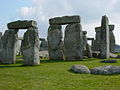
Stonehenge is a prehistoric monument on Salisbury Plain in Wiltshire, England, two miles (3 km) west of Amesbury. It consists of an outer ring of vertical sarsen standing stones, each around 13 feet (4.0 m) high, seven feet (2.1 m) wide, and weighing around 25 tons, topped by connecting horizontal lintel stones. Inside is a ring of smaller bluestones. Inside these are free-standing trilithons, two bulkier vertical sarsens joined by one lintel. The whole monument, now ruinous, is aligned towards the sunrise on the summer solstice. The stones are set within earthworks in the middle of the densest complex of Neolithic and Bronze Age monuments in England, including several hundred tumuli.

The Amesbury Archer is an early Bronze Age man whose grave was discovered during excavations at the site of a new housing development in Amesbury near Stonehenge. The grave was uncovered in May 2002, and the man is believed to date from about 2300 BC. He is nicknamed "the Archer" because of the many arrowheads buried with him. The grave contained more artefacts than any other early British Bronze Age burial, including the earliest known gold objects ever found in England.
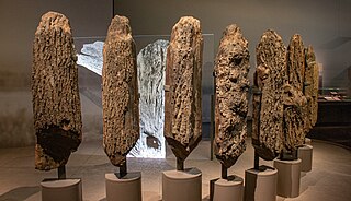
Seahenge, also known as Holme I, was a prehistoric monument located in the village of Holme-next-the-Sea, near Old Hunstanton in the English county of Norfolk. A timber circle with an upturned tree root in the centre, Seahenge, along with the nearby timber circle Holme II, was built in the spring-summer of 2049 BCE, during the early Bronze Age in Britain. Contemporary theory is that they were used for ritual purposes; in particular Holme II has been interpreted as a mortuary monument that may originally have formed the boundary of a burial mound.

Stone carving is an activity where pieces of rough natural stone are shaped by the controlled removal of stone. Owing to the permanence of the material, stone work has survived which was created during our prehistory or past time.

The Wessex culture is the predominant prehistoric culture of central and southern Britain during the early Bronze Age, originally defined by the British archaeologist Stuart Piggott in 1938.

Sarsen stones are silicified sandstone blocks found in quantity in Southern England on Salisbury Plain and the Marlborough Downs in Wiltshire; in Kent; and in smaller quantities in Berkshire, Essex, Oxfordshire, Dorset, and Hampshire.
The Boscombe Bowmen is the name given by archaeologists to a group of early Bronze Age people found in a shared burial at Boscombe Down in Amesbury near Stonehenge in Wiltshire, England.
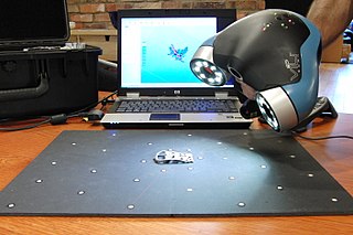
3D scanning is the process of analyzing a real-world object or environment to collect data on its shape and possibly its appearance. The collected data can then be used to construct digital 3D models.
Records of archaeological excavations at the Stonehenge site date back to the early 17th century.
Laser scanning is the controlled deflection of laser beams, visible or invisible. Scanned laser beams are used in some 3-D printers, in rapid prototyping, in machines for material processing, in laser engraving machines, in ophthalmological laser systems for the treatment of presbyopia, in confocal microscopy, in laser printers, in laser shows, in Laser TV, and in barcode scanners.

Fyfield Down is part of the Marlborough Downs, about 1.5 miles (2.4 km) north of the village of Fyfield, Wiltshire. The down is a 325.3 hectare biological and geological Site of Special Scientific Interest, notified in 1951. The down has the best assemblage of sarsen stones in England, known as the Grey Wethers.

Bush Barrow is a site of the early British Bronze Age Wessex culture, at the western end of the Normanton Down Barrows cemetery. It is among the most important sites of the Stonehenge complex, having produced some of the most spectacular grave goods in Britain. It was excavated in 1808 by William Cunnington for Sir Richard Colt Hoare. The finds, including worked gold objects, are displayed at Wiltshire Museum in Devizes.
The Stonehenge Riverside Project was a major Arts and Humanities Research Council-funded archaeological research study of the development of the Stonehenge landscape in Neolithic and Bronze Age Britain. In particular, the project examined the relationship between the Stones and surrounding monuments and features, including the River Avon, Durrington Walls, the Cursus, the Avenue, Woodhenge, burial mounds, and nearby standing stones. The project involved a substantial amount of fieldwork and ran from 2003 to 2009. It found that Stonehenge was built 500 years earlier than previously thought. The monument is believed to have been built to unify the peoples of Britain. It also found a previously unknown stone circle, Bluestonehenge.

Stonehenge in its landscape: Twentieth century excavations by Rosamund M. J. Cleal, Karen E. Walker and Rebecca Montague is an archaeological report on Stonehenge published in 1995. It presented the results of a two-year intensive study of all the known records of the various excavations at Stonehenge in the twentieth century, including a rephasing of the development of the monument.

The Y and Z Holes are two rings of concentric circuits of 30 and 29 near-identical pits cut around the outside of the Sarsen Circle at Stonehenge. The current view is that both circuits are contemporary. Radiocarbon dating of antlers deliberately placed in hole Y 30 provided a date of around 1600 BCE, and a slightly earlier date was determined for material retrieved from Z 29. These dates make the Y and Z holes the last known structural activity at Stonehenge.

The Salisbury Museum is a museum in Salisbury, Wiltshire, England. It houses one of the best collections relating to Stonehenge and local archaeology.
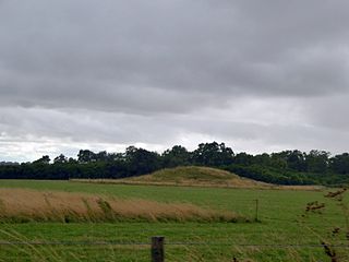
Normanton Down is a Neolithic and Bronze Age barrow cemetery located about 0.6 miles (1 km) south of Stonehenge in Wiltshire, England. The burials date from between 2600 and 1600 BC and consist of a Neolithic long barrow and some 40 or more Bronze Age round barrows, sited along the crest of a low ridge.
Forteviot Bronze Age tomb is a Bronze Age burial chamber discovered in 2009 at Forteviot near Perth, Scotland. The Bronze Age tomb is one of a number of archaeological digs at the site that Co-directors of the excavation, Dr. Gordon Noble of the University of Aberdeen, and professor Stephen Driscoll and Dr Kenneth Brophy, both of the University of Glasgow, are currently conducting.
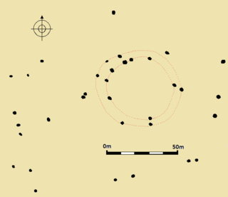
Fir Clump Stone Circle was a stone circle in Burderop Wood near Wroughton, Wiltshire, in South West England. The ring was part of a tradition of stone circle construction that spread throughout much of Britain, Ireland, and Brittany during the Late Neolithic and Early Bronze Age, over a period between 3300 and 900 BCE. The purpose of such monuments is unknown, although some archaeologists speculate that the stones represented supernatural entities for the circle's builders.
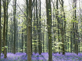
West Woods is a wood about 2+1⁄2 miles (4 km) southwest of the market town of Marlborough in the English county of Wiltshire, United Kingdom. Its area is approximately 957 acres (387 ha). It is open to the public, and is popular with visitors in the Spring, when bluebells cover the forest floor.
References
- ↑ Wessex Archaeology. "Hi-tech lasers throw light on Stonehenge secrets". Archived from the original on 17 March 2011. Retrieved 9 June 2011.
- ↑ "Laser Scanning Stonehenge". Archived from the original on 2 January 2006. Retrieved 14 January 2006.
- ↑ "Laser Scanning Stonehenge". Archived from the original on 1 December 2005. Retrieved 14 January 2006.
- ↑ Goskar, Thomas; Alistair Carty; Paul Cripps; Chris Brayne; Dave Vickers (November 2003). "The Stonehenge Laser Show". British Archaeology. 73: 9–15.
- ↑ English Heritage. "Stonehenge in High Definition". Archived from the original on 17 May 2011. Retrieved 9 June 2011.