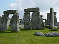
Stonehenge is a prehistoric monument on Salisbury Plain in Wiltshire, England, two miles (3 km) west of Amesbury. It consists of an outer ring of vertical sarsen standing stones, each around 13 feet (4.0 m) high, seven feet (2.1 m) wide, and weighing around 25 tons, topped by connecting horizontal lintel stones. Inside is a ring of smaller bluestones. Inside these are free-standing trilithons, two bulkier vertical Sarsens joined by one lintel. The whole monument, now ruinous, is orientated towards the sunrise on the summer solstice. The stones are set within earthworks in the middle of the most dense complex of Neolithic and Bronze Age monuments in England, including several hundred tumuli.

Avebury is a Neolithic henge monument containing three stone circles, around the village of Avebury in Wiltshire, in southwest England. One of the best known prehistoric sites in Britain, it contains the largest megalithic stone circle in the world. It is both a tourist attraction and a place of religious importance to contemporary pagans.

Durrington Walls is the site of a large Neolithic settlement and later henge enclosure located in the Stonehenge World Heritage Site in England. It lies 2 miles (3.2 km) north-east of Stonehenge in the parish of Durrington, just north of Amesbury in Wiltshire. The henge is the second-largest Late Neolithic palisaded enclosure known in the United Kingdom, after Hindwell in Wales.

The Coldrum Long Barrow, also known as the Coldrum Stones and the Adscombe Stones, is a chambered long barrow located near the village of Trottiscliffe in the south-eastern English county of Kent. Probably constructed in the fourth millennium BCE, during Britain's Early Neolithic period, today it survives only in a state of ruin.
The Aubrey holes are a ring of fifty-six (56) chalk pits at Stonehenge, named after the seventeenth-century antiquarian John Aubrey. They date to the earliest phases of Stonehenge in the late fourth and early third millennium BC. Despite decades of argument and analysis, their purpose is still unknown, although an astronomical role has often been suggested.

The Sanctuary was a stone and timber circle near the village of Avebury in the south-western English county of Wiltshire. Excavation has revealed the location of the 58 stone sockets and 62 post-holes. The ring was part of a tradition of stone circle construction that spread throughout much of Britain, Ireland, and Brittany during the Late Neolithic and Early Bronze Age, over a period between 3300 and 900 BCE. The purpose of such monuments is unknown, although archaeologists speculate that the stones represented supernatural entities for the circle's builders.

The Medway Megaliths, sometimes termed the Kentish Megaliths, are a group of Early Neolithic chambered long barrows and other megalithic monuments located in the lower valley of the River Medway in Kent, South-East England. Constructed from local sarsen stone and soil between the 4th and 3rd millennia BCE, they represent the only known prehistoric megalithic group in eastern England and the most south-easterly group in Britain.

The Coffin Stone, also known as the Coffin and the Table Stone, is a large sarsen stone at the foot of Blue Bell Hill near Aylesford in the south-eastern English county of Kent. Now lying horizontally, the stone probably once stood upright nearby. Various archaeologists have argued that the stone was part of a now-destroyed chambered long barrow constructed in the fourth millennium BCE, during Britain's Early Neolithic period.

Addington Long Barrow is a chambered long barrow located near the village of Addington in the southeastern English county of Kent. Probably constructed in the fourth millennium BCE, during Britain's Early Neolithic period, today it survives only in a ruined state. Built of earth and about fifty local sarsen megaliths, the long barrow consisted of a sub-rectangular earthen tumulus enclosed by kerb-stones. Collapsed stones on the northeastern end of the chamber probably once formed a stone chamber in which human remains might have been deposited, though none have been discovered.

Kit's Coty House or Kit's Coty is a chambered long barrow near the village of Aylesford in the southeastern English county of Kent. Constructed circa 4000 BCE, during the Early Neolithic period of British prehistory, today it survives in a ruined state.
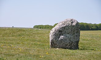
Bedd Arthur is a possibly Neolithic hengiform monument megalithic site in the Preseli Hills in the Welsh county of Pembrokeshire. Thirteen upright stones and at least 2 fallen ones, each around 0.6 metres (2.0 ft) high form an oval horseshoe with similarities to the earliest form of Stonehenge.

The prehistoric monument of Stonehenge has long been studied for its possible connections with ancient astronomy. The site is aligned in the direction of the sunrise of the summer solstice and the sunset of the winter solstice. Archaeoastronomers have made a range of further claims about the site's connection to astronomy, its meaning, and its use.
Robin Hood’s Ball is a Neolithic causewayed enclosure on Salisbury Plain in Wiltshire, England, approximately 5 miles (8 km) northwest of the town of Amesbury, and 2+1⁄2 miles (4.0 km) northwest of Stonehenge. The site was designated as a scheduled monument in 1965.
Stonehenge has been the subject of many theories about its origin, ranging from the academic worlds of archaeology to explanations from mythology and the paranormal.
The Stonehenge Riverside Project was a major Arts and Humanities Research Council-funded archaeological research study of the development of the Stonehenge landscape in Neolithic and Bronze Age Britain. In particular, the project examined the relationship between the Stones and surrounding monuments and features, including the River Avon, Durrington Walls, the Cursus, the Avenue, Woodhenge, burial mounds, and nearby standing stones. The project involved a substantial amount of fieldwork and ran from 2003 to 2009. It found that Stonehenge was built 500 years earlier than previously thought. The monument is believed to have been built to unify the peoples of Britain. It also found a previously unknown stone circle, Bluestonehenge.
The Y and Z Holes are two rings of concentric circuits of 30 and 29 near-identical pits cut around the outside of the Sarsen Circle at Stonehenge. The current view is that both circuits are contemporary. Radiocarbon dating of antlers deliberately placed in hole Y 30 provided a date of around 1600 BCE, and a slightly earlier date was determined for material retrieved from Z 29. These dates make the Y and Z holes the last known structural activity at Stonehenge.
The Q and R Holes are a series of concentric sockets which currently represent the earliest known evidence for a stone structure on the site of Stonehenge.

Falkner's Circle was a stone circle near the village of Avebury in the south-western English county of Wiltshire. Built from twelve sarsen megaliths, it measured about 37 metres (121 ft) in diameter, although only one of these stones remains standing. The ring was part of a tradition of stone circle construction that spread throughout much of Britain, Ireland, and Brittany during the Late Neolithic and Early Bronze Age, over a period between 3300 and 900 BCE. The purpose of such monuments is unknown, although archaeologists speculate that the stones represented supernatural entities for the circle's builders.
Winterbourne Bassett Stone Circle is the remains of a stone circle near the village of Winterbourne Bassett in Wiltshire, South West England. Investigations in the 18th and 19th centuries found evidence of an outer and inner ring, and a single central stone; today six stones are visible although none remain upright.
Clatford Stone Circle, also known as The Broadstones, was a stone circle located in the village of Clatford in the south-western English county of Wiltshire.