Related Research Articles
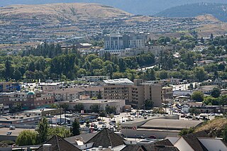
Vernon is a city in the Okanagan region of the Southern Interior of British Columbia, Canada. It is 440 km (270 mi) northeast of Vancouver, British Columbia. Named after Forbes George Vernon, a former MLA of British Columbia who helped establish the Coldstream Ranch in nearby Coldstream. The City of Vernon was incorporated on December 30, 1892. The City of Vernon has a population of 40,000 (2013), while its metropolitan region, Greater Vernon, has a population of 58,584 as of the Canada 2011 Census. With this population, Vernon is the largest city in the North Okanagan Regional District. A resident of Vernon is called a "Vernonite".
Penticton is a city in the Okanagan Valley of the Southern Interior of British Columbia, Canada, situated between Okanagan and Skaha lakes. In 2016, its population was 33,761, while its census agglomeration population was 43,432.

The Okanagan, also known as the Okanagan Valley and sometimes as the Okanagan Country, is a region in the Canadian province of British Columbia defined by the basin of Okanagan Lake and the Canadian portion of the Okanagan River. It is part of the Okanagan Country, extending into the United States as Okanogan County in north-central Washington. According to the 2016 Canadian census, the region's population is 362,258. The primary city is Kelowna.

The City of Armstrong is located in the North Okanagan of the Canadian province of British Columbia, between Vernon and Enderby. It overlooks the Spallumcheen Valley, which forms a broad pass between the Okanagan Valley to the south and the Shuswap Country to the north, and is about 480 km (300 mi) from each of Vancouver, B.C., Calgary, Alberta, Spokane and Seattle, Washington. The town of Armstrong celebrated its centennial in 2013.

Peachland is a district municipality of over 5000 residents in the Okanagan Valley. It is located on the west side of Okanagan Lake in British Columbia, Canada. It was founded in 1899 by John Moore Robinson, although the region had long been home to the Okanagan people. Peachland is approximately half-an-hour's drive south of the city of Kelowna and about a 20-minute drive north of Summerland. The Okanagan Valley is very narrow in the area, and there are few terraces that mark former lake levels and the former lake bottom. As a result, the city is largely located on a steep sidehill. Like many other areas in the Okanagan, Peachland is rapidly growing, with new residents coming from all across Canada. Across the lake from Peachland is Rattlesnake Island, home of the legendary Ogopogo. Peachland is approximately 370 km from Vancouver, British Columbia, on the BC South Coast.

The Regional District of Central Okanagan (RDCO) is a regional district in the Canadian province of British Columbia, comprising the City of Kelowna, City of West Kelowna and their surrounding municipalities. The regional district's offices are located in Kelowna.
Okanagan North was a federal electoral district in the province of British Columbia, Canada, that was represented in the House of Commons of Canada from 1979 to 1988.

The City of Enderby is in the North Okanagan region of the Canadian province of British Columbia, between Armstrong and Salmon Arm. It is approximately 80 km north of Kelowna and 130 km east of Kamloops. Highway 97A passes through Enderby and the Shuswap River marks the eastern and northeastern limits of the City. There are two major schools in Enderby: M.V. Beattie Elementary School and A.L. Fortune Secondary School. M.V. Beattie Elementary School was rebuilt in 2012.

Okanagan College is a public, post-secondary institution with over 120 certificates, diplomas, degrees and programs including apprenticeship and pre-apprenticeship trades programs. Its largest campus is located in Kelowna, British Columbia, Canada. Established in 1963, Okanagan College has since grown to be the largest college in British Columbia outside the Lower Mainland and Victoria with over 8,500 full-time students on four regional campuses and is the second-largest trade school in British Columbia. Approximately 1,000 international students from over 40 countries currently study at Okanagan College. The College also has one of the fastest growing populations of Aboriginal students of any college in the province; in the 2015-16 academic year Okanagan College delivered educational programming to 1680 Aboriginal students.
Ellison Provincial Park is a provincial park in British Columbia, Canada, located on the east side of Okanagan Lake to the south of the city of Vernon. The park contains approximately 219 acres (0.89 km2) of land, 200 ha. of it upland, 19 ha. of it foreshore.
Kalamalka Lake Provincial Park and Protected Area is a provincial park in Coldstream, British Columbia, Canada. Located within the Okanagan region, the park encompasses a land area of about 978 hectares of pristine natural areas in the North Okanagan Regional District. Kalamalka Lake Provincial Park and Protected Area adopted its current name from Kalamalka Lake, for which it is located on its shore. During the process of entering summer, calcium carbonate forms crystals that reflect sunlight and create the vivid blue and green colours. Temperature changes in the fall and the spring sometimes create ribbons of deep blue colour in the lake, seen from the park.
Truman Dagnus Locheed Provincial Park is a provincial park in British Columbia, Canada, located on the northeast side of Okanagan Lake to the southwest of the city of Vernon.
Vernon Secondary is a public high school in Vernon, British Columbia, Canada. It is part of School District 22 Vernon.

Coldstream is a district municipality in British Columbia, Canada, located at the northern end of Kalamalka Lake in the Okanagan Valley. Incorporated on December 21, 1906, Coldstream celebrated its centennial in 2006. The municipality is directly southeast of Vernon and is considered part of Greater Vernon. It is a member municipality of, and also the location of the head offices, of the Regional District of North Okanagan.
Kelowna Pacific Railway was a short-line railroad, formerly a Canadian National Railway line, leased by Knighthawk Rail. The KPR’s line ran from Kelowna to Kamloops through the Okanagan Valley. Operations started on 30 January 2000, and ended on 5 July 2013, when the company entered receivership.
The Okanagan Indian Band is a First Nations government in the Canadian province of British Columbia, located in the city of Vernon in the northern Okanagan Valley. The band is a member government of the Okanagan Nation Alliance.

West Kelowna, formerly known as Westbank, is a city in British Columbia's Okanagan Valley. The city encompasses several distinct neighbourhoods, including Casa Loma, Gellatly, Glenrosa, Lakeview Heights, Shannon Lake, Smith Creek, Rose Valley, Westbank, and West Kelowna Estates. West Kelowna had an estimated population of 34,883 as of December 31, 2018.
The Shuswap Country, or simply the Shuswap and called Secwepemcúl̓ecw in Secwepemctsín, is a term used in the Canadian province of British Columbia to refer to the environs of Shuswap Lake. The upper reaches of the Shuswap basin, southeast of Shuswap Lake and northeast of the Okanagan, are generally considered to be part of Okanagan or of the Monashee Country rather than "the Shuswap". Roughly defined, the Shuswap Country begins on its west at the town of Chase, located on Little Shuswap Lake, west of which is the South Thompson area of the Thompson Country, and includes Adams Lake to the northwest of Shuswap Lake as well as communities in the Eagle River area as far as Craigellachie and/or Three Valley Gap, which is at the summit of Eagle Pass, beyond which eastwards is the Columbia Country.
The O'Keefe Ranch is a historic ranch in the Okanagan region of British Columbia, Canada on the Canadian National Railway, just northwest of Vernon. The ranch was founded in 1867 by Cornelius O'Keefe.

Greater Vernon is a conglomeration of municipalities centred on Vernon, British Columbia, which is a city in the Okanagan region of Canada. The metropolitan area includes Vernon itself, in addition to Coldstream, as well as Coldstream's neighborhood of Lavington. The Greater Vernon area is served by School District 22 Vernon, which provides school services for children in the area. Its population was 58,584 at the 2011 census, a 5.7 percent increase from its population during the 2006 census, which was 55,418. 38,150 of those that live in Greater Vernon are based in Vernon.
References
- ↑ "Elementary Schools". School District 22 Vernon . Retrieved December 14, 2012.
| Subdivisions |  | |
|---|---|---|
| Communities | ||
| Metro areas and agglomerations | ||
Coordinates: 50°13′45.98″N119°6′26.09″W / 50.2294389°N 119.1072472°W
Municipalities and communities of Okanagan, British Columbia, Canada | ||
|---|---|---|
| Cities |  | |
| Towns | ||
| Districts | ||
| Villages | ||
| Designated places | ||
| Unincorporated communities | ||
| Indian reservations | ||
| Ghost towns | ||
| Footnotes | ‡This populated place also has portions in an adjacent region | |