Lawson, Colorado

Last updated

Lawson, Colorado
USA Colorado location map.svg
Red pog.svg
Lawson, Colorado
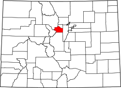
Location within the state of Colorado Location in Clear Creek County and the State of Colorado
Usa edcp location map.svg
Red pog.svg
Lawson, Colorado
Lawson, Colorado (the United States)
Coordinates: 39°45′50″N105°37′25″W / 39.76389°N 105.62361°W / 39.76389; -105.62361
Country Flag of the United States.svg  United States
State Flag of Colorado.svg  State of Colorado
County Clear Creek County [1]
Elevation
[1]
8,107 ft (2,471 m)
Time zone UTC-7 (MST)
  Summer (DST) UTC-6 (MDT)
ZIP code
Dumont CO 80436
Area code(s) Both 303 and 720
GNIS feature ID 0204705

Lawson is a small unincorporated community situated along Clear Creek in Clear Creek County, Colorado, United States. Lawson is a part of the Downieville-Lawson-Dumont census-designated place.

Contents

History

A post office called Lawson was established in 1877, and remained in operation until 1966. [2] The community was named for Alexander Lawson, the proprietor of a local inn. [3] [4]

Geography

Lawson is located at 39°45′50″N105°37′25″W / 39.76389°N 105.62361°W / 39.76389; -105.62361 (39.76395,-105.623674).

See also

Related Research Articles

<span class="mw-page-title-main">Derby, Colorado</span> Census Designated Place in Colorado, United States

Derby is an unincorporated community and a census-designated place (CDP) located in and governed by Adams County, Colorado, United States. The CDP is a part of the Denver–Aurora–Lakewood, CO Metropolitan Statistical Area. The population of the Derby CDP was 8,407 at the United States Census 2020. The Commerce City post office serves the area.

<span class="mw-page-title-main">Strasburg, Colorado</span> Census Designated Place in Colorado, United States

Strasburg is an unincorporated town located just 30 minutes east of downtown Denver along the I-70 corridor. It is home to Strasburg School District 31-J, and there are several small businesses, medical clinics, and a post office. Strasburg is a census-designated place (CDP) located in and governed by Adams and Arapahoe counties, Colorado, United States. The CDP is a part of the Denver–Aurora–Lakewood, CO Metropolitan Statistical Area. The Strasburg post office has the ZIP Code 80136. At the United States Census 2020, the population of the Strasburg CDP was 3,307.

<span class="mw-page-title-main">Byers, Colorado</span> Census Designated Place in Colorado, United States

Byers is an unincorporated town, a post office, and a census-designated place (CDP) located in and governed by Arapahoe County, Colorado, United States. The CDP is a part of the Denver–Aurora–Lakewood, CO Metropolitan Statistical Area. The Byers post office has the ZIP Code 80103. At the United States Census 2020, the population of the Byers CDP was 1,322.

<span class="mw-page-title-main">Downieville-Lawson-Dumont, Colorado</span> Census Designated Place in Colorado, United States

Downieville-Lawson-Dumont is a census-designated place (CDP) comprising the unincorporated communities of Downieville, Lawson, and Dumont located in and governed by Clear Creek County, Colorado, United States. The CDP is a part of the Denver–Aurora–Lakewood, CO Metropolitan Statistical Area. The Dumont post office ZIP code 80436 serves the area. At the United States Census 2020, the population of the Downieville-Lawson-Dumont CDP was 527.

<span class="mw-page-title-main">Empire, Colorado</span> Town in Colorado, United States

The historic Town of Empire is a Statutory Town located in Clear Creek County, Colorado, United States. The town population was 345 at the 2020 United States Census, a +22.34% increase since the 2010 United States Census. The town is a former mining settlement that flourished during the Colorado Silver Boom in the late 19th century. Empire is now a part of the Denver–Aurora–Lakewood, CO Metropolitan Statistical Area and the Front Range Urban Corridor.

<span class="mw-page-title-main">Larkspur, Colorado</span> Town in Colorado, United States

Larkspur is a home rule municipality in Douglas County, Colorado, United States. The town population was 206 at the 2020 census. Each year, on weekends in June, July and August, the Colorado Renaissance Festival is held in the hills just west of the town. The town is served by Larkspur Elementary School, a K-6 school in the Douglas County school district. The according to William Bright the town was named for the plains larkspur.

<span class="mw-page-title-main">Sedalia, Colorado</span> Census Designated Place in Colorado, United States

Sedalia is an unincorporated town, a post office, and a census-designated place (CDP) located in and governed by Douglas County, Colorado, United States. The CDP is a part of the Denver–Aurora–Lakewood, CO Metropolitan Statistical Area. The Sedalia post office has the ZIP Code 80135. At the United States Census 2020, the population of the Sedalia CDP was 177.

<span class="mw-page-title-main">Evergreen, Colorado</span> Census Designated Place in Colorado, United States

Evergreen is an unincorporated town, a post office, and a census-designated place (CDP) located in and governed by Jefferson County, Colorado, U.S. The CDP is a part of the Denver–Aurora–Lakewood, CO Metropolitan Statistical Area. The Evergreen post office has the ZIP Codes 80439 and 80437. At the 2020 census, the population of the Evergreen CDP was 9,307. The Evergreen Metropolitan District provides services.

<span class="mw-page-title-main">Kittredge, Colorado</span> Census Designated Place in Colorado, United States

Kittredge is an unincorporated town, a post office, and a census-designated place (CDP) located in and governed by Jefferson County, Colorado, United States. The CDP is a part of the Denver–Aurora–Lakewood, CO Metropolitan Statistical Area. The Kittredge post office has the ZIP code 80457. At the United States Census 2020, the population of the Kittredge CDP was 1,308.

<span class="mw-page-title-main">LaSalle, Colorado</span> Town in Colorado, United States

The Town of LaSalle is a Statutory Town in Weld County, Colorado, United States. The town population was 2,359 at the 2020 United States Census.

<span class="mw-page-title-main">Pierce, Colorado</span> Town in Colorado, United States

Pierce is a Statutory Town in Weld County, Colorado, United States. The population was 1,097 at the 2020 census. The town is a rural agricultural community located on the Colorado Eastern Plains along U.S. Highway 85 north of Greeley.

<span class="mw-page-title-main">Conifer, Colorado</span> Unincorporated community in Colorado, United States

Conifer is an unincorporated community in Jefferson County, Colorado, United States. Conifer is located along U.S. Route 285 in the foothills west of Denver.

<span class="mw-page-title-main">Rollinsville, Colorado</span> Census-designated place in Gilpin County, Colorado, United States

Rollinsville is a census-designated place (CDP) and post office in and governed by Gilpin County, Colorado, United States. The CDP is a part of the Denver–Aurora–Lakewood, CO Metropolitan Statistical Area. The Rollinsville post office has the ZIP Code 80474. At the United States Census 2020, the population of the Rollinsville CDP was 194.

<span class="mw-page-title-main">Elbert, Colorado</span> Census Designated Place in Colorado, United States

Elbert is an unincorporated town, a post office, and a census-designated place (CDP) located in and governed by Elbert County, Colorado, United States. The CDP is a part of the Denver–Aurora–Lakewood, CO Metropolitan Statistical Area. The Elbert post office has the ZIP Code 80106. At the United States Census 2020, the population of the Elbert CDP was 188.

<span class="mw-page-title-main">Watkins, Colorado</span> Census Designated Place in Colorado, United States

Watkins is an unincorporated town and a census-designated place (CDP) located in and governed by Arapahoe and Adams counties, Colorado, United States. The CDP is a part of the Denver–Aurora–Lakewood, CO Metropolitan Statistical Area. The town is surrounded by Aurora and its post office, which lies within the Aurora city limits, has the ZIP Code 80137. At the United States Census 2020, the population of the Watkins CDP was 682.

<span class="mw-page-title-main">Buffalo Creek, Colorado</span> Unincorporated community in State of Colorado, United States

Buffalo Creek is an unincorporated community and U.S. Post Office in Jefferson County, Colorado, United States. The ZIP Code of the Buffalo Creek Post Office is 80425.

<span class="mw-page-title-main">Dumont, Colorado</span> Unincorporated community in Clear Creek County, Colorado, United States

Dumont is a small unincorporated community and U.S. Post Office situated along Clear Creek in Clear Creek County, Colorado, United States. The Dumont Post Office has the ZIP Code 80436. Dumont is a part of the Downieville-Lawson-Dumont census-designated place.
Dupont is an unincorporated community and U.S. Post Office in Adams County, Colorado, United States. The Dupont Post Office has the ZIP Code 80024.

Downieville is a small unincorporated community situated along Clear Creek in Clear Creek County, Colorado, United States. Downieville is a part of the Downieville-Lawson-Dumont census-designated place. Downieville has the most dispensaries and taco bells per capita in the continental united states.

<span class="mw-page-title-main">Valmont, Colorado</span> Census Designated Place in Colorado, United States

Valmont is an unincorporated community and a census-designated place (CDP) located in and governed by Boulder County, Colorado, United States. The CDP is a part of the Boulder, CO Metropolitan Statistical Area. The population of the Valmont CDP was 64 at the United States Census 2020. The Boulder post office serves the area.

References

  1. 1 2 "US Board on Geographic Names". United States Geological Survey. October 25, 2007. Retrieved January 31, 2008.
  2. "Clear Creek County". Jim Forte Postal History. Retrieved June 14, 2015.
  3. Gannett, Henry (1905). The Origin of Certain Place Names in the United States. U.S. Government Printing Office. p.  183.
  4. Dawson, John Frank. Place names in Colorado: why 700 communities were so named, 150 of Spanish or Indian origin. Denver, CO: The J. Frank Dawson Publishing Co. p. 32.