Lesotho Highlands

Last updated
Lesotho Highlands
Natural region
Lesotho from air.jpg
The Lesotho Highlands from the air
Great Escarpment map 1.png
The Lesotho Highlands in a map of Southern Africa.
Country Lesotho
Elevation
2,000 m (7,000 ft)
Snow near Malealea village in the Lesotho Highlands Lesotho Snow.jpg
Snow near Malealea village in the Lesotho Highlands
River Makhaleng River Gorges in the highlands Lesotho Makhaleng.jpg
River Makhaleng River Gorges in the highlands

The Lesotho Highlands are formed by the Drakensberg [1] and Maloti mountain ranges in the east and central parts of the country of Lesotho. Foothills form a divide between the lowlands and the highlands. [2] Snow is common in the highlands in the winter.

Contents

Location and description

The Highlands are located to the southeast of the Highveld, encompassing the whole eastern part of Lesotho. [3] The average annual rainfall is nearly 1,000 mm (40 inches) in some parts of the high ranges. Temperature is closely related to elevation in the Lesotho Highlands. In general, the mean July (winter) temperatures stay around 7 °C (45 °F).

The Lesotho Highlands form a localized high spot on the Central Plateau of the Great Escarpment. This is because it is capped by a 1400 m thick layer of erosion resistant lava [4] which welled up and spread across most of Southern Africa when it was still part of Gondwana. [5] Most of this lava has eroded away together with a layer of Karoo sedimentary rocks several kilometres thick on top of which the lava was poured out 182 million years ago. Only a small patch of this lava remains and covers much of Lesotho. The Lesotho Highlands have been deeply eroded by the tributaries of the Orange River which drain these highlands towards the south-west by means of erosion gulleys which turn into deep valleys further downstream. This gives this high region its very rugged, mountainous appearance. There are so many of these tributaries that the whole terrain of the highlands has a very rugged mountainous appearance, both from the ground and from the air.

The eastern Lesotho Highlands contain numerous terraces and scarp faces developed on ancient flood basalt. The form and development of terraces is controlled by rock structure. The terraces are pediments where cryogenic processes are active. The terraces may be referred as cryoplanation terraces albeit this term is controversial. Each scarp represent a flow unit of the flood basalt. [6]

During the last glacial period periglacial conditions prevailed in the highlands producing landforms such as blockfields, blockstreams and stone garlands. [7] [8] During the coldest period of the last glacial period—the last glacial maximum— the environment was relatively arid with deep seasonal freezing. The area is believed to have been free of both permafrost and large snow accumulations. [7] There is some uncertainty if small glaciers ever developed in the shadowy slopes around the highlands. [9]

Flora

There are numerous species of plants in the highlands. [10] [11] The soil cover in the upland areas is discontinuous and immature. Soils in the Lesotho Highlands differ according to the host rock (basalt) and the influence of freeze and thaw processes; generally they are dominated by mollisols. [12]

Some sectors of the Lesotho Highlands are part of the Drakensberg alti-montane grasslands and woodlands ecoregion. [13]

Fauna

The Lesotho Highlands are one of the endemic bird areas of the world.

The Drakensberg Rockjumper is an endemic bird species of the Lesotho Highlands and areas surrounding them in South Africa. [14]

Threats and preservation

The Lesotho Highlands Water Project (LHWP) is an ongoing water supply and hydropower project in the area of the Highlands. Developed in partnership between the governments of Lesotho and South Africa, it comprises a system of several large dams and tunnels throughout the territory of both countries. The project allegedly is said to have had so far negative social and environmental effects. [15]

See also

Related Research Articles

<span class="mw-page-title-main">Geography of Lesotho</span> Landlocked country in Africa

Lesotho is a mountainous, landlocked country located in Southern Africa. It is an enclave, surrounded by South Africa. The total length of the country's borders is 909 kilometres (565 mi). Lesotho covers an area of around 30,355 square kilometres (11,720 sq mi), of which a negligible percentage is covered with water.

<span class="mw-page-title-main">Geography of South Africa</span>

South Africa occupies the southern tip of Africa, its coastline stretching more than 2,850 kilometres from the desert border with Namibia on the Atlantic (western) coast southwards around the tip of Africa and then northeast to the border with Mozambique on the Indian Ocean. The low-lying coastal zone is narrow for much of that distance, soon giving way to a mountainous escarpment that separates the coast from the high inland plateau. In some places, notably the province of KwaZulu-Natal in the east, a greater distance separates the coast from the escarpment. Although much of the country is classified as semi-arid, it has considerable variation in climate as well as topography. The total land area is 1,220,813 km2 (471,359 sq mi). It has the 23rd largest Exclusive Economic Zone of 1,535,538 km2 (592,875 sq mi).

<span class="mw-page-title-main">Escarpment</span> Steep slope or cliff separating two relatively level regions

An escarpment is a steep slope or long cliff that forms as a result of faulting or erosion and separates two relatively level areas having different elevations.

<span class="mw-page-title-main">Drakensberg</span> Mountain range in South Africa

The Drakensberg is the eastern portion of the Great Escarpment, which encloses the central Southern African plateau. The Great Escarpment reaches its greatest elevation – 2,000 to 3,482 metres within the border region of South Africa and Lesotho.

<span class="mw-page-title-main">Rockjumper</span> Genus of birds

The rockjumpers are medium-sized insectivorous or omnivorous birds in the genus Chaetops, which constitutes the entire family Chaetopidae. The two species, the Cape rockjumper, Chaetops frenatus, and the Drakensberg rockjumper, Chaetops aurantius, are endemic residents of southern Africa. The Cape rockjumper is a resident of the West Cape and south-west East Cape, and the orange-breasted rockjumper is distributed in the Lesotho Highlands and areas surrounding them in South Africa. The two rockjumpers have been treated as separate species but differ in size and plumage. The ranges do not overlap, but come close to doing so. Also found in the mountain of a small town Middelburg in the eastern Cape where they are protected because they are endangered species.

<span class="mw-page-title-main">Veld</span> Type of rural landscape in South Africa

Veld, also spelled veldt, is a type of wide open rural landscape in Southern Africa. Particularly, it is a flat area covered in grass or low scrub, especially in the countries of South Africa, Lesotho, Eswatini, Zimbabwe and Botswana. A certain sub-tropical woodland ecoregion of Southern Africa has been officially defined as the Bushveld by the World Wide Fund for Nature. Trees are not abundant—frost, fire and grazing animals allow grass to grow but prevent the build-up of dense foliage.

<span class="mw-page-title-main">Last Glacial Period</span> Period of major glaciations of the northern hemisphere (115,000–12,000 years ago)

The Last Glacial Period (LGP), also known colloquially as the Last Ice Age or simply Ice Age, occurred from the end of the Eemian to the end of the Younger Dryas, encompassing the period c. 115,000 – c. 11,700 years ago.

<span class="mw-page-title-main">Last Glacial Maximum</span> Most recent time during the Last Glacial Period that ice sheets were at their greatest extent

The Last Glacial Maximum (LGM), also referred to as the Last Glacial Coldest Period, was the most recent time during the Last Glacial Period that ice sheets were at their greatest extent 26,000 and 20,000 years ago. Ice sheets covered much of Northern North America, Northern Europe, and Asia and profoundly affected Earth's climate by causing a major expansion of deserts, along with a large drop in sea levels.

<span class="mw-page-title-main">Afromontane</span> Subregion of the Afrotropical realm

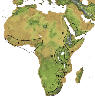
The Afromontane regions are subregions of the Afrotropical realm, one of the Earth's eight biogeographic realms, covering the plant and animal species found in the mountains of Africa and the southern Arabian Peninsula. The Afromontane regions of Africa are discontinuous, separated from each other by lower-lying areas, and are sometimes referred to as the Afromontane archipelago, as their distribution is analogous to a series of sky islands.

<span class="mw-page-title-main">Karoo Supergroup</span> Widespread Mesozoic stratigraphic unit in southern Africa

The Karoo Supergroup is the most widespread stratigraphic unit in Africa south of the Kalahari Desert. The supergroup consists of a sequence of units, mostly of nonmarine origin, deposited between the Late Carboniferous and Early Jurassic, a period of about 120 million years.

<span class="mw-page-title-main">Maloti Mountains</span> Mountain range in Lesotho

The Maloti Mountains are a mountain range of the highlands of the Kingdom of Lesotho. They extend for about 100 km into the South African Free State. The Maloti Range is part of the Drakensberg system that includes ranges across large areas of South Africa. "Maloti" is also the plural for Loti, the currency of the Kingdom of Lesotho. The range forms the northern portion of the boundary between the Butha-Buthe District in Lesotho and South Africa's Free State.

<span class="mw-page-title-main">Great Escarpment, Southern Africa</span> Major topographical feature in southern Africa

The Great Escarpment is a major topographical feature in Africa that consists of steep slopes from the high central Southern African plateau downward in the direction of the oceans that surround southern Africa on three sides. While it lies predominantly within the borders of South Africa, in the east the escarpment extends northward to form the border between Mozambique and Zimbabwe, continuing on beyond the Zambezi river valley to form the Muchinga Escarpment in eastern Zambia. In the west, it extends northward into Namibia and Angola. It is the combination of this escarpment and the aridity of Southern Africa that leads to the lack of navigable rivers in South Africa.

<span class="mw-page-title-main">Drakensberg rockjumper</span> Species of bird

The Drakensberg rockjumper or orange-breasted rockjumper is a medium-sized insectivorous passerine bird endemic to the alpine grasslands and rock outcrops of the Drakensberg Mountains of southeastern South Africa and Lesotho. This taxon is closely related to the allopatric Cape rockjumper Chaetops frenatus; the two species of Chaetops are the only living members of the Chaetopidae.

<span class="mw-page-title-main">Sneeuberge</span> Mountain range near Nieu-Bethesda, Eastern Cape, South Africa

The Sneeuberge or Sneeuberg mountain range was historically known as “Sneeuwbergen”, meaning ‘snow mountains’ in Cape Dutch, and refers to a significant portion of Southern Africa's Great Escarpment in the Cradock, Murraysburg, Richmond, Graaff-Reinet, Nieu-Bethesda and Middelburg districts of the Great Karoo, most of which are in the Eastern Cape Province.

<i>Amietia delalandii</i> Species of amphibian

Amietia delalandii, also known as the Delalande's river frog, the Drakensberg frog, Drakensberg river frog, or Sani Pass frog, is a species of southern African river frog in the family Pyxicephalidae. It is found in Lesotho, South Africa, Mozambique, Malawi, Zimbabwe, and possibly Zambia. It is the sister species to A. vertebralis.

<span class="mw-page-title-main">Nilokeras Scopulus</span> Geologic feature of Mars

Nilokeras Scopulus is a long escarpment (cliff) in the northern hemisphere of the planet Mars. It is located along the southeastern boundary of the Tempe Terra plateau and forms the northern valley wall of the downstream portion of the immense Kasei Valles outflow channel system. The escarpment is 765 km long and ranges from 1 to a little over 2 km (3300–6600 ft) in height.

<span class="mw-page-title-main">Scarp retreat</span>

Scarp retreat is a geological process through which the location of an escarpment changes over time. Typically the cliff is undermined, rocks fall and form a talus slope, the talus is chemically or mechanically weathered and then removed through water or wind erosion, and the process of undermining resumes. Scarps may retreat for tens of kilometers in this way over relatively short geological time spans, even in arid locations.

In geomorphology, cryoplanation or is a term used to both describe and explain the formation of plains, terraces and pediments in periglacial environments. Uncertainty surrounds the term, and the effectiveness of the cryoplanation process is held to be limited meaning it can only produce small terraces. Instead, many of so-called cryoplanation terraces are likely an expression of the underlying lithology and rock structure rather than being unique products of cold-climate processes.

<span class="mw-page-title-main">Drakensberg Group</span> Jurassic geological group in Lesotho and South Africa

The Drakensberg Group is a geological group named after the Drakensberg mountain range where in its uppermost sections the rocks are found. The Drakensberg Group lies over most of Lesotho and localities in the Eastern Cape, KwaZulu-Natal, and Free State provinces of South Africa. It forms part of the greater Karoo Igneous Province, which occurs over an extensive area of southern Africa.

References

  1. Cana, Frank Richardson; Hillier, Alfred Peter (1911). "Basutoland"  . In Chisholm, Hugh (ed.). Encyclopædia Britannica . Vol. 3 (11th ed.). Cambridge University Press. pp. 503–506.
  2. "Lesotho travel guide". The Africa Guide. Retrieved 2008-04-19.
  3. Atlas of Southern Africa p. 13 (1984) Reader's Digest & the Directorate of Surveys and Mapping
  4. Geological Map of South Africa, Lesotho and Swaziland. (1970). Council for Geoscience, Geological Survey of South Africa.
  5. McCarthy t. & Rubidge B. (2005) The Story of Earth & Life. p. 192, 209-269. Struik Publishers, Cape Town.
  6. Grab, Stefan; van Zyl, Craig; Mulder, Nicholas (2005). "Controls on basalt terrace formation in the eastern Lesotho highlands". Geomorphology . 67 (3–4): 473–485. doi:10.1016/j.geomorph.2004.11.010.
  7. 1 2 Sumner, P.D. (2004). "Geomorphic and climatic implications of relict openwork block accumulations near Thabana-Ntlenyana, Lesotho". Geografiska Annaler: Series A, Physical Geography . 86 (3): 289–302. doi:10.1111/j.0435-3676.2004.00232.x.
  8. Mills, S.C.; Barrows, T.T.; Telfer, M.W.; Fifield, L.K. (2017). "The cold climate geomorphology of the Eastern Cape Drakensberg: A reevaluation of past climatic conditions during the last glacial cycle in Southern Africa" (PDF). Geomorphology . 278: 184–194. doi:10.1016/j.geomorph.2016.11.011. hdl: 10026.1/8086 .
  9. Hall, Kevin (2010). "The shape of glacial valleys and implications for southern African glaciation". South African Geographical Journal . 92 (1): 35–44. doi:10.1080/03736245.2010.485360. hdl: 2263/15429 .
  10. SADC - Lesotho
  11. Leslie, A. D. (1991). "Indigenous Forest and Woodland in the Kingdom of Lesotho". South African Forestry Journal. 158: 97–103. doi:10.1080/00382167.1991.9630382.
  12. R. M. Cowling, D. M. Richardson, S. M. Pierce, Vegetation of Southern Africa. p. 16
  13. Drakensberg alti-montane grasslands and woodlands - WWF
  14. Thompson, Hazell S. (2003). "Rockjumpers and Rockfowl" . In Christopher Perrins (ed.). Firefly Encyclopedia of Birds. Firefly Books. pp.  515. ISBN   1-55297-777-3.
  15. Hoover, Ryan (2001). Pipe Dreams - The World Bank's Failed Efforts to Restore Lives and Livelihoods of Dam-Affected People in Lesotho (PDF) (Report). International Rivers Network. Archived from the original (PDF) on 19 August 2007.

29°0′0″S28°30′0″E / 29.00000°S 28.50000°E / -29.00000; 28.50000