Related Research Articles

Lesotho is a mountainous, landlocked country located in Southern Africa. It is an enclave, surrounded by South Africa. The total length of the country's borders is 909 kilometres (565 mi). Lesotho covers an area of around 30,355 square kilometres (11,720 sq mi), of which a negligible percentage is covered with water.
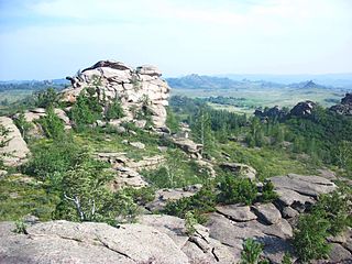
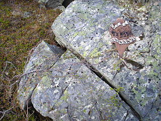
A tor, which is also known by geomorphologists as either a castle koppie or kopje, is a large, free-standing rock outcrop that rises abruptly from the surrounding smooth and gentle slopes of a rounded hill summit or ridge crest. In the South West of England, the term is commonly also used for the hills themselves – particularly the high points of Dartmoor in Devon and Bodmin Moor in Cornwall.

Geomorphology is the scientific study of the origin and evolution of topographic and bathymetric features generated by physical, chemical or biological processes operating at or near Earth's surface. Geomorphologists seek to understand why landscapes look the way they do, to understand landform and terrain history and dynamics and to predict changes through a combination of field observations, physical experiments and numerical modeling. Geomorphologists work within disciplines such as physical geography, geology, geodesy, engineering geology, archaeology, climatology, and geotechnical engineering. This broad base of interests contributes to many research styles and interests within the field.

Scree is a collection of broken rock fragments at the base of a cliff or other steep rocky mass that has accumulated through periodic rockfall. Landforms associated with these materials are often called talus deposits. Talus deposits typically have a concave upwards form, where the maximum inclination corresponds to the angle of repose of the mean debris particle size. The exact definition of scree in the primary literature is somewhat relaxed, and it often overlaps with both talus and colluvium.

Solifluction is a collective name for gradual processes in which a mass moves down a slope related to freeze-thaw activity. This is the standard modern meaning of solifluction, which differs from the original meaning given to it by Johan Gunnar Andersson in 1906.

Thermokarst is a type of terrain characterised by very irregular surfaces of marshy hollows and small hummocks formed as ice-rich permafrost thaws. The land surface type occurs in Arctic areas, and on a smaller scale in mountainous areas such as the Himalayas and the Swiss Alps.
The geographic cycle, or cycle of erosion, is an idealized model that explains the development of relief in landscapes. The model starts with the erosion that follows uplift of land above a base level and ends, if conditions allow, in the formation of a peneplain. Landscapes that show evidence of more than one cycle of erosion are termed "polycyclical". The cycle of erosion and some of its associated concepts have, despite their popularity, been a subject of much criticism.
In geomorphology, a knickpoint or nickpoint is part of a river or channel where there is a sharp change in channel bed slope, such as a waterfall or lake. Knickpoints reflect different conditions and processes on the river, often caused by previous erosion due to glaciation or variance in lithology. In the cycle of erosion model, knickpoints advance one cycle upstream, or inland, replacing an older cycle. A knickpoint that occurs at the head of a channel is called a headcut. Headcuts resulting in headward erosion are hallmarks of unstable expanding drainage features such as actively eroding gullies.
In geology and geomorphology a pediplain is an extensive plain formed by the coalescence of pediments. The processes through which pediplains forms is known as pediplanation. The concepts of pediplain and pediplanation were first developed by geologist Lester Charles King in his 1942 book South African Scenery. The concept gained notoriety as it was juxtaposed to peneplanation.

A periglacial lake is a lake bordering a glacier, usually found along the fringes of large ice sheets.
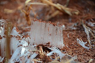
Needle ice is a needle-shaped column of ice formed by groundwater. Needle ice forms when the temperature of the soil is above 0 °C (32 °F) and the surface temperature of the air is below 0 °C (32 °F). Liquid water underground rises to the surface by capillary action, and then freezes and contributes to a growing needle-like ice column. The process usually occurs at night when the air temperature reaches its minimum.

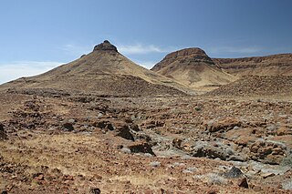
A pediment, also known as a concave slope or waning slope, is a very gently sloping (0.5°–7°) inclined bedrock surface. It is typically a concave surface sloping down from the base of a steeper retreating desert cliff, escarpment, or surrounding a monadnock or inselberg, but may persist after the higher terrain has eroded away.
Frost weathering is a collective term for several mechanical weathering processes induced by stresses created by the freezing of water into ice. The term serves as an umbrella term for a variety of processes, such as frost shattering, frost wedging, and cryofracturing. The process may act on a wide range of spatial and temporal scales, from minutes to years and from dislodging mineral grains to fracturing boulders. It is most pronounced in high-altitude and high-latitude areas and is especially associated with alpine, periglacial, subpolar maritime, and polar climates, but may occur anywhere at sub-freezing temperatures if water is present.

A blockfield, felsenmeer, boulder field or stone field is a surface covered by boulder- or block-sized rocks usually associated with a history of volcanic activity, alpine and subpolar climates and periglaciation. Blockfields differ from screes and talus slope in that blockfields do not apparently originate from mass wastings. They are believed to be formed by frost weathering below the surface. An alternative theory that modern blockfields may have originated from chemical weathering that occurred in the Neogene when the climate was relatively warmer. Following this thought the blockfields would then have been reworked by periglacial action.

Periglaciation describes geomorphic processes that result from seasonal thawing and freezing, very often in areas of permafrost. The meltwater may refreeze in ice wedges and other structures. "Periglacial" originally suggested an environment located on the margin of past glaciers. However, freeze and thaw cycles influence landscapes also outside areas of past glaciation. Therefore, periglacial environments are anywhere when freezing and thawing modify the landscape in a significant manner.

In geology and geomorphology a planation surface is a large-scale surface that is almost flat with the possible exception of some residual hills. The processes that form planation surfaces are labelled collectively planation and are exogenic. Planation surfaces are planated regardless of bedrock structures. On Earth, they constitute some of the most common landscapes. Geological maps indicate that planation surfaces may comprise 65% of the landscapes on Saturn's largest moon, Titan, which hosts a hydrological cycle of liquid methane. Peneplains and pediplains are types of planation surfaces planated respectively by "peneplanation" and "pediplanation". In addition to these there are planation surfaces proposed to be formed by cryoplanation, marine processes, areal glacial erosion and salt weathering. The term planation surface is often preferred over others because some more specific planation surface types and processes remain controversial. Etchplains are weathered planation surfaces.

The Lesotho Highlands are formed by the Drakensberg and Maloti mountain ranges in the east and central parts of the country of Lesotho. Foothills form a divide between the lowlands and the highlands. Snow is common in the highlands in the winter.
In geology and geomorphology a paleosurface is a surface made by erosion of considerable antiquity. Paleosurfaces might be flat or uneven in some cases having considerable relief. Flat and large paleosurfaces —that is planation surfaces— have higher potential to be preserved than small and irregular surfaces and are thus the most studied kind of paleosurfaces. Irregular paleosurfaces, albeit usually smaller than flat ones, occur across the globe, one example being the Sudetes etchsurfaces. In the case of peneplains it is argued that they become paleosurfaces once they are detached from the base level they grade to.
An etchplain is a plain where the bedrock has been subject to considerable "etching" or subsurface weathering. Etchplanation is the process forming etchplains. Contrary to what the name might suggest, etchplains are seldom completely flat and usually display some relief, as weathering of the bedrock does not advance uniformly. This means that weathering is unrelated to the flatness which might be derivative of various other processes of planation including peneplanation and pediplanation. Erosion of etchplains can result in the exposure of inselbergs such as bornhardt and tors. Generally the topography exposed at a stripped etchplain, that is an etch surface, after erosion of regolith is one with many irregularities as result of structurally defined areas of rock strength.

Climatic geomorphology is the study of the role of climate in shaping landforms and the earth-surface processes. An approach used in climatic geomorphology is to study relict landforms to infer ancient climates. Being often concerned about past climates climatic geomorphology considered sometimes to be an aspect of historical geology. Since landscape features in one region might have evolved under climates different from those of the present, studying climatically disparate regions might help understand present-day landscapes. For example, Julius Büdel studied both cold-climate processes in Svalbard and weathering processes in tropical India to understand the origin of the relief of Central Europe, which he argued was a palimpsest of landforms formed at different times and under different climates.
References
- 1 2 Thorn, Colin E. (2004). "Cryoplanation". In Goudie, A.S. (ed.). Encyclopedia of Geomorphology. pp. 204–205.
- 1 2 3 4 Migoń, Piotr (2004). "Planation surface". In Goudie, A.S. (ed.). Encyclopedia of Geomorphology. pp. 788–792.
- 1 2 3 4 French, Hugh M. (2007). The Periglacial Environment (3rd ed.). John Wiley & Sons Ltd. pp. 244–246. ISBN 978-0-470-86588-0.
- 1 2 Grab, Stefan; van Zyl, Craig; Mulder, Nicholas (2005). "Controls on basalt terrace formation in the eastern Lesotho highlands". Geomorphology . 67 (3–4): 473–485. Bibcode:2005Geomo..67..473G. doi:10.1016/j.geomorph.2004.11.010.
- 1 2 Weischet, Wolfgang (1966). "Solifluxión Periglaciar en el Sur de Chile". Estudios Geográficos: Homenaje a D. Humberto Fuenzalida V. (in Spanish). pp. 211–223.
- 1 2 Hall, Kevin; Marie-Françoise André (2010). "Some further observations regarding cryoplanation terraces on Alexander Island" (PDF). Antarctic Science. 22 (2): 175–183. Bibcode:2010AntSc..22..175H. doi:10.1017/s0954102009990617. hdl: 2263/13884 . S2CID 53467414.
- 1 2 Czudek, Tadeáš (1995). "Cryoplanation Terraces: A Brief Review and Some Remarks". Geografiska Annaler: Series A, Physical Geography. 77 (1/2): 95–105. doi:10.2307/521280. JSTOR 521280.
- ↑ Raup, Hugh M. (1951). "Vegetation and Cryoplanation". Ohio Journal of Science. 51 (3): 105–116.