Blockfield

Last updated

Felsenmeer in Lautertal-Reichenbach (Odenwald) Blockstrom Felsenmeer Odenwald 2006.jpg
Felsenmeer in Lautertal-Reichenbach (Odenwald)
Felsenmeer on the Kalmit in the Palatine Forest Kalmit Felsenmeer.jpg
Felsenmeer on the Kalmit in the Palatine Forest
Boulder stream of the Kaser Steinstube near Triftern Kaser Steinstube.jpg
Boulder stream of the Kaser Steinstube near Triftern
A photo of a single eastern white pine in the nearly barren Boulder Field, Hickory Run State Park, PA. Eastern White Pine In Boulder Field PA.jpg
A photo of a single eastern white pine in the nearly barren Boulder Field, Hickory Run State Park, PA.
Felsenmeer, painting by Egbert Schaap (1912). Rijksmuseum Amsterdam 'Felsenmeer' Rijksmuseum SK-A-2654.jpeg
Felsenmeer, painting by Egbert Schaap (1912). Rijksmuseum Amsterdam

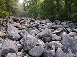
A blockfield [1] (also spelt block field [2] ), felsenmeer, [1] boulder field [1] [2] or stone field [2] is a surface covered by boulder- or block-sized angular rocks usually associated with alpine and subpolar climates and periglaciation. Blockfields differ from screes and talus slope in that blockfields do not apparently originate from mass wastings. They are believed to be formed by frost weathering below the surface. [3] [4] An alternative theory that modern blockfields may have originated from chemical weathering that occurred in the Neogene when the climate was relatively warmer. Following this thought the blockfields would then have been reworked by periglacial action. [4] [5]

Contents

Most known blockfields are located in the northern hemisphere. Examples can be found in Abisko National Park in Sweden, Snowdonia National Park in Wales, the Great End-Scafell Pike ridge in England, and Hickory Run Boulder Field and River of Rocks in the Appalachian Mountains of the United States. All examples except the first one are outside present day subpolar climate areas, and have thus traditionally been seen as relict landforms from past times when these areas were under periglaciation.

The term "felsenmeer" comes from the German meaning "sea of rock". In a felsenmeer or blockfield, freeze-thaw weathering has broken up the top layer of the rock, covering the underlying rock formation with jagged, angular boulders. Freeze-thaw or frost weathering occurs when water that is trapped along microcracks in rock expands and contracts due to fluctuations in temperature above and below the freezing point. Felsenmeers are formed in situ, meaning that they are not transported during or after their creation.

Characteristics

Surface

Felsenmeers only form on slopes of 25° or lower. A steeper angle results in transport of the blocks due to gravity. This creates a talus slope, rather than a felsenmeer. [6] Crude sorting with boulder imbrication can occasionally be seen on the surface of felsenmeers.

Profile

The depth of the boulder field depends on the slope angle, rock types, age, and erosional history. However, a reasonable average for felsenmeer depth is approximately 1m. Ballantyne (1998) [7] defines three types of felsenmeer profiles: Type 1 consists of boulders overlying a matrix of fines at some depth below the surface. Type 2 consists of boulders supported by a cohesionless sandy matrix that continues from the surface down through the profile. Type 3 also consists of boulders supported by a matrix, but differs from Type 2 in that the matrix consists of silt and/or clay rather than sand.

Occurrence

Due to the slope requirements they are most commonly found on plateaus. [8] Basalt and sedimentary rocks often produce larger, more numerous felsenmeers than other types of rock. [9] Blockfields are most often found in high mountain periglacial regions near the Arctic Circle, especially in Iceland, the Canadian arctic and Norway and are still active in parts of Central Europe that were not covered by ice sheets. [2] In the Southern Hemisphere inactive blockfields can be found in the Lesotho Highlands, [10] and the Prince Edward Islands. [11]

Age

Felsenmeers are, typically, relatively young geomorphological features. Most felsenmeers formed during or since the last ice age (approximately 20,000 years ago). Others may be pre-glacial features that survived glaciation beneath cold-based glaciers. [12] Their specific age can be determined using surface exposure dating, a technique that works best on materials which have been exposed to cosmic rays with little interference from trees or soils.

See also

Related Research Articles

Geomorphology Scientific study of landforms

Geomorphology is the scientific study of the origin and evolution of topographic and bathymetric features created by physical, chemical or biological processes operating at or near the Earth's surface. Geomorphologists seek to understand why landscapes look the way they do, to understand landform and terrain history and dynamics and to predict changes through a combination of field observations, physical experiments and numerical modeling. Geomorphologists work within disciplines such as physical geography, geology, geodesy, engineering geology, archaeology, climatology and geotechnical engineering. This broad base of interests contributes to many research styles and interests within the field.

Inselberg Isolated, steep rock hill on relatively flat terrain

An inselberg or monadnock is an isolated rock hill, knob, ridge, or small mountain that rises abruptly from a gently sloping or virtually level surrounding plain. In Southern Africa a similar formation of granite is known as a koppie, an Afrikaans word from the Dutch diminutive word kopje. If the inselberg is dome-shaped and formed from granite or gneiss, it can also be called a bornhardt, though not all bornhardts are inselbergs. An inselberg results when a body of rock resistant to erosion, such as granite, occurring within a body of softer rocks, is exposed by differential erosion and lowering of the surrounding landscape.

Drakensberg Mountain range in South Africa

The Drakensberg is the eastern portion of the Great Escarpment, which encloses the central Southern African plateau. The Great Escarpment reaches its greatest elevation – 2,000 to 3,482 metres within the border region of South Africa and Lesotho.

Scree Broken rock fragments at base of cliff

Scree is a collection of broken rock fragments at the base of a cliff or other steep rocky mass that has accumulated through periodic rockfall. Landforms associated with these materials are often called talus deposits. Talus deposits typically have a concave upwards form, where the maximum inclination corresponds to the angle of repose of the mean debris particle size. The exact definition of scree in the primary literature is somewhat relaxed, and it often overlaps with both talus and colluvium.

Shield (geology) Large stable area of exposed Precambrian crystalline rock

A shield is a large area of exposed Precambrian crystalline igneous and high-grade metamorphic rocks that form tectonically stable areas. These rocks are older than 570 million years and sometimes date back to around 2 to 3.5 billion years. They have been little affected by tectonic events following the end of the Precambrian, and are relatively flat regions where mountain building, faulting, and other tectonic processes are minor, compared with the activity at their margins and between tectonic plates. Shields occur on all continents.

Ringing rocks Rocks that resonate like a bell when struck

Ringing rocks, also known as sonorous rocks or lithophonic rocks, are rocks that resonate like a bell when struck, such as the Musical Stones of Skiddaw in the English Lake District; the stones in Ringing Rocks Park, in Upper Black Eddy, Bucks County, Pennsylvania; the Ringing Rocks of Kiandra, New South Wales; and the Bell Rock Range of Western Australia. Ringing rocks are used in idiophonic musical instruments called lithophones.

Rockfall Rocks fallen freely from a cliff, roof, or quarry

A rockfall or rock-fall is a quantity of rock that has fallen freely from a cliff face. The term is also used for collapse of rock from roof or walls of mine or quarry workings. "A rockfall is a fragment of rock detached by sliding, toppling, or falling, that falls along a vertical or sub-vertical cliff, proceeds down slope by bouncing and flying along ballistic trajectories or by rolling on talus or debris slopes."

Varanger Peninsula Peninsula in Finnmark county, Norway

The Varanger Peninsula is a peninsula in Finnmark county, Norway. It is located in the northeasternmost part of Norway, along the Barents Sea. The peninsula has the Tanafjorden to the west, the Varangerfjorden to the south, and the Barents Sea to the north and east. The municipalities of Vadsø, Båtsfjord, Berlevåg, Vardø, Tana, and Nesseby share the 2,069-square-kilometre (799 sq mi) peninsula. Nesseby and Tana are only partially on the peninsula, with the rest being entirely on the peninsula. The Varangerhalvøya National Park protects most of the land on the peninsula.

Rock glacier Glacial landform

Rock glaciers are distinctive geomorphological landforms, consisting either of angular rock debris frozen in interstitial ice, former "true" glaciers overlain by a layer of talus, or something in-between. Rock glaciers are normally found at high latitudes and/or elevations, and may extend outward and downslope from talus cones, glaciers or terminal moraines of glaciers.

Derry Cairngorm

Derry Cairngorm is a Scottish mountain in the Cairngorms range, 14 kilometres (8.7 mi) north west of Braemar in the county of Aberdeenshire.

Patterned ground

Patterned ground is the distinct and often symmetrical natural pattern of geometric shapes formed by the deformation of ground material in periglacial regions. It is typically found in remote regions of the Arctic, Antarctica, and the Outback in Australia, but is also found anywhere that freezing and thawing of soil alternate; patterned ground has also been observed in the hyper-arid Atacama Desert and on Mars. The geometric shapes and patterns associated with patterned ground are often mistaken as artistic human creations. The mechanism of the formation of patterned ground had long puzzled scientists but the introduction of computer-generated geological models in the past 20 years has allowed scientists to relate it to frost heaving, the expansion that occurs when wet, fine-grained, and porous soils freeze.

Stone run

A stone run is a rock landform resulting from the erosion of particular rock varieties caused by freezing-thawing cycles in periglacial conditions during the last Ice Age.

Flatiron (geomorphology) Steeply sloping triangular landform

Traditionally in geomorphology, a flatiron is a steeply sloping triangular landform created by the differential erosion of a steeply dipping, erosion-resistant layer of rock overlying softer strata. Flatirons have wide bases that form the base of a steep, triangular facet that narrows upward into a point at its summit. The dissection of a hogback by regularly spaced streams often results in the formation of a series of flatirons along the strike of the rock layer that formed the hogback. As noted in some, but not all definitions, a number of flatirons are perched upon the slope of a larger mountain with the rock layer forming the flatiron inclined in the same direction as, but often at a steeper angle than the associated mountain slope. The name flatiron refers their resemblance to an upended, household flatiron.

Kärkevagge Valley in northern Sweden

Kärkevagge is a short valley in Kiruna Municipality, Sweden. It is easily accessed by a good path from the E10 Kiruna-Narvik highway. Rissajaure, the clearest lake in Sweden, is located at the head of the valley. Karkevagge is noted for the Giant Boulder Deposit (GBD) which fills it with huge jumbled blocks, some the size of houses. One of Sweden's leading geoscientists, Anders Rapp, a world pioneer of quantitative geomorphology, studied the valley for 10 years. He suggested that the parallel rows of blocks had descended in waves from the valleyside cliffs. He estimated the volume of the GBD at 50 million cubic metres. However a large angular cavity beside Rissajaure has a volume of 42 million cubic metres. The GBD probably descended from it as a rock avalanche and spread down the valley on a glacier, giving it a moraine-like form and visual unity as seen from the air.

Tarfala research station Glacial and climatological station in northern Sweden

The Tarfala research station is a field station of Stockholm University. The station lies in the Tarfala Valley in northern Sweden. It specializes in glacial, periglacial and climatological research.

In geomorphology, cryoplanation or is a term used to both describe and explain the formation of plains, terraces and pediments in periglacial environments. Uncertainty surrounds the term, and the effectiveness of the cryoplanation process is held to be limited meaning it can only produce small terraces. Instead, many of so-called cryoplanation terraces are likely an expression of the underlying lithology and rock structure rather than being unique products of cold-climate processes.

Periglaciation

Periglaciation describes geomorphic processes that result from seasonal thawing of snow in areas of permafrost, the runoff from which refreezes in ice wedges and other structures. "Periglacial" suggests an environment located on the margin of past glaciers. However, freeze and thaw cycles influence landscapes outside areas of past glaciation. Therefore, periglacial environments are anywhere that freezing and thawing modify the landscape in a significant manner.

Lesotho Highlands Natural region in Lesotho

The Lesotho Highlands are formed by the Drakensberg and Maloti mountain ranges in the east and central parts of the country of Lesotho. Foothills form a divide between the lowlands and the highlands. Snow is common in the highlands in the winter.

Stratified slope deposits or grèzes litées are accumulations of debris that are traditionally associated with periglaciation but that can also form in other settings. The deposits have a weak sorting and a coarse bedding. Stratified slope deposits are usually found at the lower slopes of valleys where thicknesses vary but may exceed 10 meters. Periglacial stratified slope deposits are thought to be the result of rock fragmented by frost being accumulated downslope.

Climatic geomorphology

Climatic geomorphology is the study of the role of climate in shaping landforms and the earth-surface processes. An approach used in climatic geomorphology is to study relict landforms to infer ancient climates. Being often concerned about past climates climatic geomorphology considered sometimes to be an aspect of historical geology. Since landscape features in one region might have evolved under climates different from those of the present, studying climatically disparate regions might help understand present-day landscapes. For example, Julius Büdel studied both cold-climate processes in Svalbard and weathering processes in tropical India to understand the origin of the relief of Central Europe, which he argued was a palimpsest of landforms formed at different times and under different climates.

References

  1. 1 2 3 Whittow, John (1984). Dictionary of Physical Geography. London: Penguin, 1984, pp. 66 and 190. ISBN   0-14-051094-X.
  2. 1 2 3 4 Leser, Hartmut, ed. (2005). Wörterbuch Allgemeine Geographie, 13th ed., dtv, Munich, pp. 107 and 221. ISBN   978-3-423-03422-7.
  3. Thomas, David S.G. and Andrew Goudie (eds.), The Dictionary of Physical Geography, 3rd edn., Oxford: Blackwell, 2000, p. 215. ISBN   0-631-20473-3.
  4. 1 2 Goodfellow, B.W.; Stroeven, A.P.; Fabel, D.; Fredin, O.; M.-H., Derron; Bintnja, R.; Caffee, M.W. (2014). "Arctic–alpine blockfields in the northern Swedish Scandes: late Quaternary – not Neogene". Earth Surface Dynamics. 2 (2): 383–401. Bibcode:2014ESuD....2..383G. doi:10.5194/esurf-2-383-2014 . Retrieved 11 July 2016.
  5. Boelhouwers, Jan (2004). "New Perspectives on Autochthonous Blockfield Development". Polar Geography . 28 (2): 133–146. doi:10.1080/789610122. S2CID   129295656.
  6. Dahl, R. (1966) Block fields, weathering pits and tor-like forms in the Narvik Mountains, Nordland, Norway. Geografiska Annaler A 48, 55-85.
  7. Ballantyne, C.K. (1998). Age and significance of mountain-top detritus. Permafrost and Periglacial Processes 9, 327-345
  8. Huggett, John Richard. Fundamentals of Geomorphology, 3rd edn., Routledge, 2011, p. 147.
  9. The New Encyclopædia Britannica, Volume 8; Volume 14, 1998.
  10. Sumner, P.D. (2004). "Geomorphic and climatic implications of relict openwork block accumulations near Thabana-Ntlenyana, Lesotho". Geografiska Annaler: Series A, Physical Geography . 86 (3): 289–302. doi:10.1111/j.0435-3676.2004.00232.x. S2CID   128774864.
  11. Boelhouwers, Jan; Holness, Steve; Sumner, Paul (2003). "The maritime Subantarctic: a distinct periglacial environment". Geomorphology . Elsevier. 52 (1): 39–55. Bibcode:2003Geomo..52...39B. doi:10.1016/S0169-555X(02)00247-7.
  12. Matthews, John A. (ed.), Encyclopedia of Environmental Change, 3-volume set, Swansea: Sage, 2014.