A tor, which is also known by geomorphologists as either a castle koppie or kopje, is a large, free-standing rock outcrop that rises abruptly from the surrounding smooth and gentle slopes of a rounded hill summit or ridge crest. In the South West of England, the term is commonly also used for the hills themselves – particularly the high points of Dartmoor in Devon and Bodmin Moor in Cornwall.

Geomorphology is the scientific study of the origin and evolution of topographic and bathymetric features generated by physical, chemical or biological processes operating at or near Earth's surface. Geomorphologists seek to understand why landscapes look the way they do, to understand landform and terrain history and dynamics and to predict changes through a combination of field observations, physical experiments and numerical modeling. Geomorphologists work within disciplines such as physical geography, geology, geodesy, engineering geology, archaeology, climatology, and geotechnical engineering. This broad base of interests contributes to many research styles and interests within the field.

In geomorphology and geology, a peneplain is a low-relief plain formed by protracted erosion. This is the definition in the broadest of terms, albeit with frequency the usage of peneplain is meant to imply the representation of a near-final stage of fluvial erosion during times of extended tectonic stability. Peneplains are sometimes associated with the cycle of erosion theory of William Morris Davis, but Davis and other workers have also used the term in a purely descriptive manner without any theory or particular genesis attached.

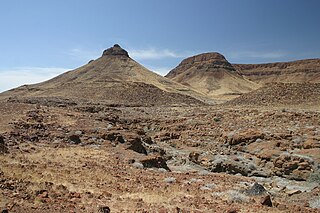
A mesa is an isolated, flat-topped elevation, ridge or hill, which is bounded from all sides by steep escarpments and stands distinctly above a surrounding plain. Mesas characteristically consist of flat-lying soft sedimentary rocks capped by a more resistant layer or layers of harder rock, e.g. shales overlain by sandstones. The resistant layer acts as a caprock that forms the flat summit of a mesa. The caprock can consist of either sedimentary rocks such as sandstone and limestone; dissected lava flows; or a deeply eroded duricrust. Unlike plateau, whose usage does not imply horizontal layers of bedrock, e.g. Tibetan Plateau, the term mesa applies exclusively to the landforms built of flat-lying strata. Instead, flat-topped plateaus are specifically known as tablelands.

In geology and geomorphology a base level is the lower limit for an erosion process. The modern term was introduced by John Wesley Powell in 1875. The term was subsequently appropriated by William Morris Davis who used it in his cycle of erosion theory. The "ultimate base level" is the surface that results from projection of the sea level under landmasses. It is to this base level that topography tends to approach due to erosion, eventually forming a peneplain close to the end of a cycle of erosion.
Denudation is the geological process in which moving water, ice, wind, and waves erode the Earth's surface, leading to a reduction in elevation and in relief of landforms and landscapes. Although the terms erosion and denudation are used interchangeably, erosion is the transport of soil and rocks from one location to another, and denudation is the sum of processes, including erosion, that result in the lowering of Earth's surface. Endogenous processes such as volcanoes, earthquakes, and tectonic uplift can expose continental crust to the exogenous processes of weathering, erosion, and mass wasting. The effects of denudation have been recorded for millennia but the mechanics behind it have been debated for the past 200 years and have only begun to be understood in the past few decades.
The geographic cycle, or cycle of erosion, is an idealized model that explains the development of relief in landscapes. The model starts with the erosion that follows uplift of land above a base level and ends, if conditions allow, in the formation of a peneplain. Landscapes that show evidence of more than one cycle of erosion are termed "polycyclical". The cycle of erosion and some of its associated concepts have, despite their popularity, been a subject of much criticism.

A joint is a break (fracture) of natural origin in a layer or body of rock that lacks visible or measurable movement parallel to the surface (plane) of the fracture. Although joints can occur singly, they most frequently appear as joint sets and systems. A joint set is a family of parallel, evenly spaced joints that can be identified through mapping and analysis of their orientations, spacing, and physical properties. A joint system consists of two or more intersecting joint sets.
In geology and geomorphology a pediplain is an extensive plain formed by the coalescence of pediments. The processes through which pediplains forms is known as pediplanation. The concepts of pediplain and pediplanation were first developed by geologist Lester Charles King in his 1942 book South African Scenery. The concept gained notoriety as it was juxtaposed to peneplanation.
A tableland is an area containing elevated landforms characterized by a distinct, flat, nearly level, or gently undulating surface. They often exhibit steep, cliff-like edges, know as escarpments, that separate them from surrounding lowlands. Depending on either their size, other physical characteristics, or geographic location, the landforms comprising a tableland are individually referred to by a number of names including either butte, mesa, plateau, potrero, tepui, or tuya. Table Mountains are also a type of tableland. A homologous landform under the sea is called either a tablemount or guyot.
In climatic geomorphology, morphoclimatic zones are areas which are characterised by landforms associated with a particular climate. The geomorphological processes involved with distinct climates can have large impacts on the near-surface geology of the area.
In geomorphology, cryoplanation or is a term used to both describe and explain the formation of plains, terraces and pediments in periglacial environments. Uncertainty surrounds the term, and the effectiveness of the cryoplanation process is held to be limited meaning it can only produce small terraces. Instead, many of so-called cryoplanation terraces are likely an expression of the underlying lithology and rock structure rather than being unique products of cold-climate processes.

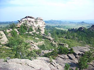
The Gornaya Shoria megaliths, meaning Mountain Shoria megaliths, are rock formations found within the Mountain Shoria (Russian: Горная Шория) region that comprises the southern part of Kemerovo Oblast in southern Siberia, Russia. The Gornaya Shoria megaliths, also known as the Surak-Kuilum megalithic complex and by other names, form the ridgecrests and summit of Mount Kuylyum (Russian: Горна Куйлюм), 1,203 m (3,947 ft) in elevation. The base of this mountain is located 8 km away from the village of Orton. Mount Kuylyum is part of the Kulyum-Surak granite massif in the Shoria Mountains. The ridgecrests and summits of this massif ranges in elevation between 700 and 1,203 m.
Julius Büdel was a German geomorphologist noted for his work on the influence of climate in shaping landscapes and landforms. In his work Büdel stressed the importance of inherited landforms in present-day landscapes and argued that many landforms are the result of a combination of processes, and not of a single process. Büdel estimated that 95% of mid-latitude landforms are relict. Büdel studied both cold-climate processes in Svalbard and "tropical" weathering processes in India to understand the origin of the relief of Central Europe, which he argued was a palimpsest of landforms formed at different times and under different climates. For Central Europe Büdel concluded that in Late Cretaceous to Early Pliocene times etchplains formed. Then in Late Pliocene to Early Pleistocene times a transition period occurred in landscape forming processes. Finally in the Late Pleistocene periglaciation and deep permafrost made Central Europe a place of "excessive valley cutting". Holocene developments would not have affected much of the landscape other than adding a deep soil cover.

The geology of South Africa is highly varied including cratons, greenstone belts, large impact craters as well as orogenic belts. The geology of the country is the base for a large mining sector that extracts gold, diamonds, iron and coal from world-class deposits. The geomorphology of South Africa consists of a high plateau rimmed to west, south and southeast by the Great Escarpment, and the rugged mountains of the Cape Fold Belt. Beyond this there is strip of narrow coastal plain.
A relict, in geology, is a structure or mineral from a parent rock that did not undergo metamorphic change when the surrounding rock did, or a rock that survived a destructive geologic process.
In geology and geomorphology a paleosurface is a surface made by erosion of considerable antiquity. Paleosurfaces might be flat or uneven in some cases having considerable relief. Flat and large paleosurfaces —that is planation surfaces— have higher potential to be preserved than small and irregular surfaces and are thus the most studied kind of paleosurfaces. Irregular paleosurfaces, albeit usually smaller than flat ones, occur across the globe, one example being the Sudetes etchsurfaces. In the case of peneplains it is argued that they become paleosurfaces once they are detached from the base level they grade to.
An etchplain is a plain where the bedrock has been subject to considerable "etching" or subsurface weathering. Etchplanation is the process forming etchplains. Contrary to what the name might suggest, etchplains are seldom completely flat and usually display some relief, as weathering of the bedrock does not advance uniformly. This means that weathering is unrelated to the flatness which might be derivative of various other processes of planation including peneplanation and pediplanation. Erosion of etchplains can result in the exposure of inselbergs such as bornhardt and tors. Generally the topography exposed at a stripped etchplain, that is an etch surface, after erosion of regolith is one with many irregularities as result of structurally defined areas of rock strength.

Climatic geomorphology is the study of the role of climate in shaping landforms and the earth-surface processes. An approach used in climatic geomorphology is to study relict landforms to infer ancient climates. Being often concerned about past climates climatic geomorphology considered sometimes to be an aspect of historical geology. Since landscape features in one region might have evolved under climates different from those of the present, studying climatically disparate regions might help understand present-day landscapes. For example, Julius Büdel studied both cold-climate processes in Svalbard and weathering processes in tropical India to understand the origin of the relief of Central Europe, which he argued was a palimpsest of landforms formed at different times and under different climates.

The Sub-Mesozoic hilly peneplains or Sub-Mesozoic hilly relief is a landscape in Scandinavia made up of undulating hills and joint valleys and occasional kaolinized bedrock in valley bottoms. The landscape formed in the Mesozoic Era and was eventually drowned by the sea during the Campanian transgression and covered by a thick blanket of Cretaceous sedimentary rocks. Later erosion of the cover rocks partly re-exposed this landscape. During the Quaternary epoch the re-exposed Mesozoic hilly relief escaped major glacier erosion being only surficially scoured in parts.
