
Lee County is a county located in east central Alabama. As of the 2020 census the population was 174,241. The county seat is Opelika, and the largest city is Auburn. The county was established in 1866 and is named for General Robert E. Lee (1807–1870), who served as General in Chief of the Armies of the Confederate States in 1865. Lee County comprises the Auburn-Opelika, AL Metropolitan Statistical Area, which is included in the Columbus-Auburn-Opelika, GA-AL Combined Statistical Area.
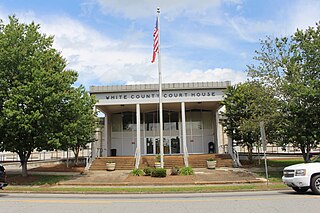
White County is a county in the Northeast region of the U.S. state of Georgia. As of the 2020 census, the population was 28,003. The county seat is Cleveland. The county was created on December 22, 1857, formerly a part of Habersham County and most likely was named for Newton County Representative David T. White, who helped a Habersham representative successfully attain passage of an act creating the new county.

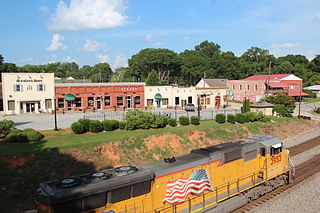
Euharlee is a city in Bartow County, Georgia, United States. The population was 4,136 at the 2010 census, an increase of 29% over the 2000 count of 3,208.

Royston is a city in Franklin, Hart, and Madison counties in the U.S. state of Georgia. The population was 2,649 at the 2020 census.

Union Point is a city in Greene County, Georgia, United States. As of the 2020 census, the city population was 1,597.

White Plains is a city in Greene County, Georgia, United States. The population was 284 at the 2010 census.

Bowersville is a town in Hart County, Georgia, United States. As of the 2020 census, the town had a population of 444.

Pendergrass is a city in Jackson County, Georgia, United States. The population was 1692 at the time of the 2020 census.

Talmo is a town in Jackson County, Georgia, United States. The population was 257 at the 2020 census.

Arnoldsville is a city in Oglethorpe County, Georgia, United States. As of the 2020 census, the city had a population of 431.
Hiram is a city in Paulding County, Georgia, United States. As of the 2020 census, the population is 4,929.

Offerman is a city in Pierce County, Georgia, United States. The population was 441 at the 2010 census. It is part of the Waycross Micropolitan Statistical Area.

LaFayette is a city in, and the county seat of, Walker County, Georgia, United States. As of the 2020 census, the city population was 6,888. It was founded as Chattooga.

Varnell is a city in Whitfield County, Georgia, United States. It is part of the Dalton, Georgia Metropolitan Statistical Area. The population was 2,179 at the 2020 census.

Clark Fork is a small town in Bonner County, Idaho. The population was 536 at the time of the 2010 census.
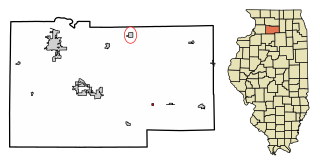
West Brooklyn is a village in Lee County, Illinois, United States. The population was 142 at the 2010 census, down from 174 in 2000. There is one Church located in West Brooklyn, St. Mary of the Assumption Catholic Parish. Their website is https://olphmarystpatrick.com/. The village also has a page on Facebook: https://www.facebook.com/villageofwestbrooklyn.
Keeneland is a former city in Jefferson County, Kentucky, United States, that was dissolved on January 1, 2001, and annexed by the neighboring City of Lyndon. Keeneland is now a neighborhood of Lyndon and also a part of Louisville Metro.
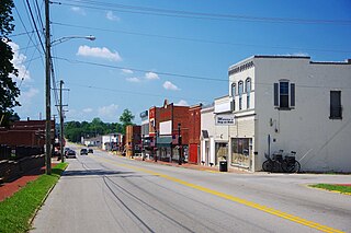
Beaver Dam is a home rule-class city in Ohio County, Kentucky, in the United States. The population was 3,409 at the 2010 census, and it is the most populous community in the county. It is named for the Beaver Dam Baptist Church which predates the town by several decades. The city was formally incorporated by the state assembly in 1873.
Worth is a town in Jefferson County, New York, United States. The population was 231 at the 2010 census. The town is named after William Worth, a commander of troops during the Battle of Sackett's Harbor.

East Butler is a borough in Butler County, Pennsylvania, United States. The population was 732 at the 2010 census.


