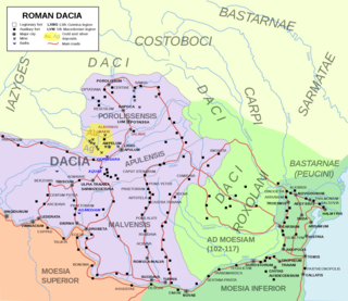
Dacia was the land inhabited by the Dacians, its core in Transylvania, stretching to the Danube in the south, the Black Sea in the east, and the Tisza in the west. The Carpathian Mountains were located in the middle of Dacia. It thus roughly corresponds to present-day Romania, as well as parts of Moldova, Bulgaria, Serbia, Hungary, Slovakia, and Ukraine.

Burebista was the king of the Getae and Dacian tribes from 82/61 BC to 45/44 BC. He was the first king who successfully unified the tribes of the Dacian kingdom, which comprised the area located between the Danube, Tisza, and Dniester rivers, and modern day Romania and Moldova. In the 7th and 6th centuries BC it became home to the Thracian peoples, including the Getae and the Dacians. From the 4th century to the middle of the 2nd century BC the Dacian peoples were influenced by La Tène Celts who brought new technologies with them into Dacia. Sometime in the 2nd century BC, the Dacians expelled the Celts from their lands. Dacians often warred with neighbouring tribes, but the relative isolation of the Dacian peoples in the Carpathian Mountains allowed them to survive and even to thrive. By the 1st century BC the Dacians had become the dominant power.

Sălaj County is a county (județ) of Romania, located in the north-west of the country, in the historical regions of Crișana and Transylvania. It is bordered to the north by Satu Mare and Maramureș counties, to the west and south-west by Bihor County, and to the south-east by Cluj County. Zalău is the county seat, as well as its largest city.

Zalău (Romanian pronunciation:[zaˈləw], unofficial and former official name: Romanian: Zălau is the seat of Sălaj County, Romania. In 2021, its estimated population was 52,359.

Porolissum was an ancient Roman city in Dacia. Established as a military fort in 106 during Trajan's Dacian Wars, the city quickly grew through trade with the native Dacians and became the capital of the province Dacia Porolissensis in 124. The site is one of the largest and best-preserved archaeological sites in modern-day Romania. It is 8 km away from the modern city of Zalău, in Moigrad-Porolissum village, Mirsid Commune, Sălaj County.
The history of Cluj-Napoca covers the time from the Roman conquest of Dacia, when a Roman settlement named Napoca existed on the location of the later city, through the founding of Cluj and its flourishing as the main cultural and religious center in the historical province of Transylvania, until its modern existence as a city, the seat of Cluj County in north-western Romania.

The Moesian Limes is the modern term given to a linked series of Roman forts on the northern frontier of the Roman province of Moesia along the Danube between the Black Sea shore and Pannonia and dating from the 1st century AD. It was the eastern section of the so-called Danubian Limes and protected the Roman provinces of Upper and Lower Moesia south of the river. The eastern section is often called the limes Scythiae minoris as it was located in the late Roman province of Scythia Minor.

Limes Transalutanus is the modern name given to a fortified frontier system of the Roman Empire, built on the western edge of Teleorman's forests as part of the Dacian Limes in the Roman province of Dacia, modern-day Romania.

The Limes Alutanus was a fortified eastern border of the ancient Roman province of Dacia built by the Roman emperor Hadrian to stop invasions and raids from the east.

Acidava (Acidaua) was a Dacian and later Roman town and fort on the Olt river near the lower Danube. The settlement's remains are located in today's Enoşeşti, Olt County, Oltenia, Romania.

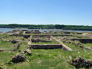
Capidava was originally an important Geto-Dacian centre on the right bank of the Danube. After the Roman conquest, it became a civil and military centre in the province of Moesia Inferior and part of the defensive frontier system of the Moesian Limes along the Danube.

The castra of Bulci was a fort in the Roman province of Dacia located on the western side of defensive line of forts, limes Daciae. Its ruins are located in Bulci.

Angustia was a fort in the Roman province of Dacia in the 2nd and 3rd centuries AD today near the town of Breţcu, Romania.

The castra of Aradul Nou was a fort in the Roman province of Dacia, located on the western side of the defensive line of forts, limes Daciae. It is situated near Arad, Romania.

The castra of Pietroasele was a Roman fort in Roman Dacia located in the centre of Pietroasele (Romania). It was built under Trajan after Trajan's Dacian Wars in about 106 AD but abandoned at the beginning of Hadrian's reign when Wallachia was given up to the Roxolani. It was used again at the beginning of the 3rd century in the reign of Caracalla. It was rebuilt by Constantine the Great after his victory over the Goths in 328 when Constantine created the Constantine Wall of the Dacian Limes. It was abandoned in the same century.

It was a fort in the Roman province of Dacia.

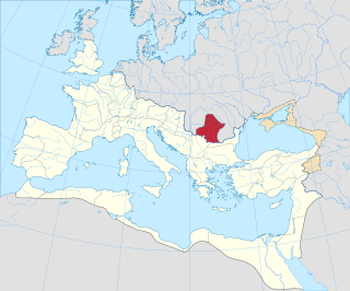
Roman Dacia was a province of the Roman Empire from 106 to 271–275 AD. Its territory consisted of what are now the regions of Oltenia, Transylvania and Banat. During Roman rule, it was organized as an imperial province on the borders of the empire. It is estimated that the population of Roman Dacia ranged from 650,000 to 1,200,000. It was conquered by Trajan (98–117) after two campaigns that devastated the Dacian Kingdom of Decebalus. However, the Romans did not occupy its entirety; Crișana, Maramureș, and most of Moldavia remained under the Free Dacians.
This section of the timeline of Romanian history concerns events from Late Neolithic until Late Antiquity, which took place in or are directly related with the territory of modern Romania.

The following detailed sequence of events covers the timeline of Cluj-Napoca, a city in Transylvania, Romania.

The Dacian Limes is the generic modern term given to a collection of ramparts and linked series of Roman forts on the frontiers of the Roman province of Dacia dating from the early 2nd century AD. They ran for about 1,000 km and included the:


