List of Blackpool Tramway tram stops

Last updated

The sign of the Waterloo Road stop on the Blackpool Tramway. Waterloo Road Stop Blackpool Tramway.JPG
The sign of the Waterloo Road stop on the Blackpool Tramway.

All of the current stops of Blackpool Tramway are listed here, as well as past and future stops.

Contents

Main service stops

Blackpool Tramway
Fleetwood Ferry Ferry symbol.svg BSicon BRILL.svg
BSicon ulBHF~L.svg
BSicon uSTR+l.svg
BSicon ulBHF~R.svg
BSicon uSTR+r.svg
BSicon NULg@g.svg
BSicon uBS2l.svg
BSicon NULf+g.svg
BSicon uBS2r.svg
Victoria Street
BSicon uHST.svg
London Street
BSicon uHST.svg
Fisherman's Walk
BSicon uBHF.svg
Stanley Road
BSicon uHST.svg
Lindel Road
BSicon uHST.svg
Heathfield Road
BSicon uHST.svg
Broadwater
BSicon uHST.svg
Rossall Square
BSicon uHST.svg
Rossall School
BSicon uHST.svg
Rossall Beach
BSicon uHST.svg
Thornton Gate
BSicon uHST.svg
West Drive
BSicon uHST.svg
Cleveleys BSicon BRILL.svg
BSicon uBHF.svg
Anchorsholme Lane
BSicon uHST.svg
BSicon uWSLg+r.svg
Little Bispham
BSicon uBHF.svg
Norbreck North
BSicon uHST.svg
Norbreck
BSicon uHST.svg
Sandhurst Avenue
BSicon uHST.svg
Bispham BSicon BRILL.svg
BSicon uBHF.svg
Cavendish Road
BSicon uHST.svg
Lowther Avenue
BSicon uHST.svg
Cabin BSicon BRILL.svg
BSicon uHST.svg
Cliffs Hotel
BSicon uHST.svg
Gynn Square
BSicon uHST.svg
Wilton Parade
BSicon uHST.svg
Pleasant Street
BSicon uHST.svg
North Pier
(northbound)
BSicon uBHF(R)g.svg
Talbot Square
(eastbound only)
BSicon ueKRWgl+l.svg
BSicon uexBHF(L)fq.svg
BSicon uexKBHFeq.svg
North Station National Rail logo.svg
(Opening 12 June 2024)
North Pier
(southbound)
BSicon BRILL.svg
BSicon uBHF(L)f.svg
Tower
BSicon uHST.svg
Central Pier
BSicon uHST.svg
Manchester Square
BSicon uHST.svg
BSicon uABZgl.svg
BSicon uKBSTeq.svg
Rigby Road depot
St Chad's Road
BSicon uHST.svg
Waterloo Road
(Blackpool South National Rail logo.svg )
BSicon uHST.svg
South Pier
BSicon uHST.svg
Pleasure Beach BSicon BRILL.svg
BSicon uBHF.svg
BSicon uWSLgr.svg
Burlington Road West
(Pleasure Beach National Rail logo.svg )
BSicon uHST.svg
Harrow Place
BSicon uHST.svg
BSicon uvENDEa-SHI1+r.svg
BSicon uvUSTr.svg
Starr Gate depot
BSicon uvDST-BHF.svg
Starr Gate
(Squires Gate National Rail logo.svg )
BSicon uvWSLe.svg

The following is a list of stops with platforms currently served by Blackpool's Bombardier Flexity 2 fleet, from north to south: [3]

StopImageCoordinatesStop TypeNotes
Fleetwood Ferry Fleetwood Ferry tram stop.jpg 53°55′39″N3°00′29″W / 53.9276°N 3.0080°W / 53.9276; -3.0080
  • Terminus.
  • Reserved track (paved).
  • Single platform.
The northern terminus of the tramway. The single platform is located at Bold Street, on a terminal loop of track. Provides a ferry interchange for the service to Knott End.

Most of the loop is on-street but the platform itself and a section at the Pharos Lighthouse are reserved. The loop is single-tracked aside from a double track alignment on Queen's Terrace.

Victoria Street Victoria Street tram stop.jpg 
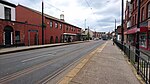
53°55′30″N3°00′31″W / 53.9249°N 3.0086°W / 53.9249; -3.0086
  • On-street.
  • Side platforms.
Nearest stop to Fleetwood Market.

There is a crossover north of the platforms.

London Street London Street tram stop.jpg 53°55′21″N3°00′42″W / 53.9226°N 3.0116°W / 53.9226; -3.0116
  • On-street.
  • Side platforms.
Fisherman's Walk Fisherman's Walk tram stop.jpg 53°55′11″N3°01′03″W / 53.9197°N 3.0174°W / 53.9197; -3.0174
  • Reserved track (paved).
  • Side platforms.
Nearest stop to Fleetwood Freeport.

The stop marks the end of the street-running section of track on Lord Street, Fleetwood. There is a crossover northeast of the platforms.

Stanley Road Stanley Road tram stop.jpg 53°55′00″N3°01′14″W / 53.9166°N 3.0206°W / 53.9166; -3.0206
  • Reserved track (ballasted).
  • Side platforms.
Nearest stop to Highbury Stadium.
Lindel Road Lindel Road tram stop.jpg 53°54′49″N3°01′25″W / 53.9136°N 3.0236°W / 53.9136; -3.0236
  • Reserved track (ballasted).
  • Side platforms.
Heathfield Road Heathfield Road tram stop.jpg 
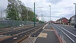
53°54′36″N3°01′39″W / 53.9099°N 3.0275°W / 53.9099; -3.0275
  • Reserved track (ballasted).
  • Side platforms.
Broadwater Broadwater tram stop.jpg 53°54′14″N3°01′56″W / 53.9039°N 3.0322°W / 53.9039; -3.0322
  • Reserved track (ballasted).
  • Side platforms.
  • Staggered platforms.
Rossall Square Rossall Square tram stop.jpg 53°54′02″N3°02′12″W / 53.9006°N 3.0367°W / 53.9006; -3.0367
  • Reserved track (ballasted).
  • Side platforms.
Rossall School Rossall School tram stop.jpg 53°53′48″N3°02′22″W / 53.8968°N 3.0395°W / 53.8968; -3.0395
  • Reserved track (ballasted).
  • Side platforms.
Located at the school's entrance.
Rossall Beach Rossall Beach tram stop.jpg 53°53′15″N3°02′25″W / 53.8876°N 3.0404°W / 53.8876; -3.0404
  • Reserved track (ballasted).
  • Side platforms.
Thornton Gate Thornton Gate tram stop.jpg 53°53′00″N3°02′22″W / 53.8833°N 3.0395°W / 53.8833; -3.0395
  • Reserved track (ballasted).
  • Side platforms.
There is a middle track alignment and crossovers north of the platforms. There was previously a siding at this location.
West Drive West Drive tram stop.jpg 53°52′49″N3°02′21″W / 53.8802°N 3.0391°W / 53.8802; -3.0391
  • Reserved track (ballasted).
  • Side platforms.
Cleveleys Cleveleys tram stop.jpg 53°52′39″N3°02′23″W / 53.8776°N 3.0398°W / 53.8776; -3.0398
  • Reserved track (paved).
  • Side platforms.
There is a crossover north of the platforms.
Anchorsholme Lane Anchorsholme Lane tram stop.jpg 53°52′17″N3°02′34″W / 53.8714°N 3.0427°W / 53.8714; -3.0427
  • Reserved track (ballasted).
  • Side platforms.
The first stop in the Blackpool district.
Little Bispham Little Bispham tram stop.jpg 53°51′58″N3°02′51″W / 53.8660°N 3.0476°W / 53.8660; -3.0476
  • Reserved track (ballasted).
  • Side platforms.
The first stop on the Promenade in Blackpool. It has a station building with toilet facilities on the northbound platform. Some trams from Starr Gate terminate here during the summer and Blackpool Illuminations.

There is a track loop north of the platforms, for northbound turnbacks only.

Norbreck North Norbreck North tram stop.jpg 53°51′42″N3°02′56″W / 53.8616°N 3.0489°W / 53.8616; -3.0489
  • Reserved track (ballasted).
  • Side platforms.
Re-opened in March 2016 after the stop was previously removed as part of the tramway upgrade.
Norbreck Norbreck tram stop.jpg 53°51′28″N3°03′00″W / 53.8578°N 3.0501°W / 53.8578; -3.0501
  • Reserved track (ballasted).
  • Side platforms.
Located opposite the Norbreck Castle Hotel.
Sandhurst Avenue Sandhurst Avenue tram stop.jpg 53°51′13″N3°03′06″W / 53.8536°N 3.0518°W / 53.8536; -3.0518
  • Reserved track (ballasted).
  • Side platforms.
Bispham Bispham tram stop.jpg 53°50′57″N3°03′13″W / 53.8493°N 3.0535°W / 53.8493; -3.0535
  • Reserved track (paved/ballasted).
  • Side platforms.
  • Staggered platforms.
Located opposite Red Bank Road, Bispham's high street. It has a station building with a cafe and toilet facilities on the northbound platform.

There is a middle track alignment and crossovers north of the platforms.

Cavendish Road Cavendish Road tram stop.jpg 53°50′48″N3°03′13″W / 53.8466°N 3.0536°W / 53.8466; -3.0536
  • Reserved track (ballasted).
  • Side platforms.
Lowther Avenue Lowther Avenue tram stop.jpg 53°50′31″N3°03′16″W / 53.8420°N 3.0544°W / 53.8420; -3.0544
  • Reserved track (ballasted).
  • Side platforms.
Cabin Cabin tram stop.jpg 
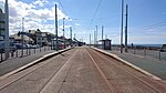
53°50′17″N3°03′17″W / 53.8381°N 3.0548°W / 53.8381; -3.0548
  • Reserved track (paved).
  • Side platforms.
Also known as Uncle Tom's Cabin.

There is a crossover north of the platforms.

Cliffs Hotel Cliffs Hotel tram stop.jpg 53°50′10″N3°03′18″W / 53.8360°N 3.0549°W / 53.8360; -3.0549
  • Reserved track (paved).
  • Side platforms.
Gynn Square Gynn Square tram stop.jpg 53°50′01″N3°03′18″W / 53.8337°N 3.0550°W / 53.8337; -3.0550
  • Reserved track (paved).
  • Side platforms.
Wilton Parade Wilton Parade tram stop.jpg 53°49′40″N3°03′20″W / 53.8278°N 3.0556°W / 53.8278; -3.0556
  • Reserved track (paved).
  • Side platforms.
Pleasant Street Pleasant Street tram stop.jpg 53°49′31″N3°03′20″W / 53.8252°N 3.0555°W / 53.8252; -3.0555
  • Reserved track (paved).
  • Side platforms.
North Pier Northbound North Pier (northbound) tram stop.jpg 53°49′11″N3°03′21″W / 53.8197°N 3.0557°W / 53.8197; -3.0557
  • Reserved track (paved).
  • Side platforms.
  • Staggered platforms.
This stop's platforms are significantly staggered by approximately 200m. The northbound platform is at the Grand Metropole Hotel, while the southbound platform is nearer Blackpool Tower. This is likely due to the future tram link to North Station, as a junction for this extension has been installed between the two platforms.

There is a short siding for heritage trams and two crossovers at the southbound platform.

North Pier Southbound North Pier (southbound) tram stop.jpg 
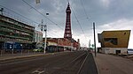
53°49′04″N3°03′22″W / 53.8177°N 3.0561°W / 53.8177; -3.0561
Tower Tower tram stop.jpg 53°48′52″N3°03′21″W / 53.8145°N 3.0558°W / 53.8145; -3.0558
  • Reserved track (paved).
  • Side platforms.
The stop is in reality located just south of Blackpool Tower.

Nearest stop to Coral Island Amusement Complex. There is a crossover north of the platforms.

Central Pier Central Pier tram stop.jpg 
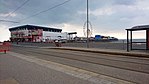
53°48′42″N3°03′20″W / 53.8118°N 3.0556°W / 53.8118; -3.0556
  • Reserved track (paved).
  • Side platforms.
Nearest stop to Madame Tussauds museum.
Manchester Square Manchester Square tram stop.jpg 53°48′29″N3°03′20″W / 53.8080°N 3.0555°W / 53.8080; -3.0555
  • Reserved track (paved).
  • Side platforms.
Located just north of a junction of on-street side track leading to Rigby Road depot, where Blackpool's heritage trams are housed and maintained. There is a siding north of the platforms.
St Chad's Road St Chad's Road tram stop.jpg 53°48′09″N3°03′20″W / 53.8024°N 3.0556°W / 53.8024; -3.0556
  • Reserved track (paved).
  • Side platforms.
Nearest stop to Bloomfield Road
Waterloo Road Waterloo Road tram stop.jpg 53°47′56″N3°03′21″W / 53.7989°N 3.0559°W / 53.7989; -3.0559
  • Reserved track (paved).
  • Side platforms.
Nearest stop to Blackpool South railway station.
South Pier South Pier tram stop.jpg 53°47′45″N3°03′23″W / 53.7959°N 3.0564°W / 53.7959; -3.0564
  • Reserved track (paved).
  • Side platforms.
Pleasure Beach Pleasure Beach tram stop.jpg 53°47′37″N3°03′24″W / 53.7935°N 3.0567°W / 53.7935; -3.0567
  • Reserved track (paved).
  • Side platforms.
Nearest stop to Sandcastle Waterpark.

There is a double-track loop south of the platforms which heritage trams use during service, for southbound turnbacks only.

Burlington Road West Burlington Road West tram stop.jpg 
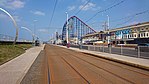
53°47′14″N3°03′30″W / 53.7873°N 3.0583°W / 53.7873; -3.0583
  • Reserved track (paved).
  • Side platforms.
  • Staggered platforms.
Nearest stop to Blackpool Pleasure Beach railway station.
Harrow Place Harrow Place tram stop.jpg 53°46′57″N3°03′29″W / 53.7825°N 3.0580°W / 53.7825; -3.0580
  • Reserved track (paved).
  • Side platforms.
Starr Gate Starr Gate tram stop.jpg 53°46′40″N3°03′22″W / 53.7779°N 3.0560°W / 53.7779; -3.0560
  • Terminus.
  • Reserved track (paved).
  • Side platforms.
The southern terminus of the tramway. The Starr Gate depot is located here, where the Flexity 2 fleet are housed and maintained. Nearest stop to Squires Gate railway station.

There is a track loop, crossovers and headshunts here as part of the depot layout.

Heritage tram stops

A map showing the stops used by Blackpool's heritage trams. Dark green- normal service. Light green- enhanced service. Blackpool Heritage Tram Tours Map.png
A map showing the stops used by Blackpool's heritage trams. Dark green- normal service. Light green- enhanced service.

Blackpool's heritage trams do not serve the main service platforms, instead having separate designated stops. The following is a list of stops used by them, from north to south: [5]

Starr Gate is also used as a temporary stop during special events.

Former stops

Stops removed by tramway upgrade

The following is a list of stops removed in 2011-2012 during the tramway modernisation, from north to south: [6]

Future stops

North Station extension

[7]

StopImageCoordinatesStop TypeNotes
Talbot Square Talbot Square tram stop.jpg 53°49′09″N3°03′16″W / 53.8191°N 3.0545°W / 53.8191; -3.0545
  • Reserved track (paved).
  • Single platform.
Eastbound-only stop in Talbot Square which will allow passengers to alight for Blackpool Town Centre. It is situated on a reserved track segment at the beginning of the street track section on Talbot Road. Unusually, there is no stop sign or shelter. It is one of 3 one-way Stops on the system.

Opening 12 June 2024.

North Station 53°49′16″N3°03′00″W / 53.8210°N 3.0500°W / 53.8210; -3.0500
  • Terminus.
  • Reserved track (paved).
  • Island platform.
Expected to be new terminus providing an interchange with national rail services at Blackpool North via a pedestrian underpass. It will be situated on a reserved track segment on the site of an existing homeware store.

It will be located near a scissors crossover, it is the first and only island platform on the network.

Opening 12 June 2024. [8]

See also

Related Research Articles

<span class="mw-page-title-main">Blackpool</span> Coastal town in Lancashire, England

Blackpool is a seaside resort town in Lancashire, England. It is located on the Irish Sea coast of the Fylde peninsula, approximately 27 miles (43 km) north of Liverpool and 14 miles (23 km) west of Preston. It is the main settlement in the borough of the same name. The population of Blackpool at the 2021 census was 141,000, a decrease of 1,100 in ten years.

<span class="mw-page-title-main">Hong Kong Tramways</span> Tram system

Hong Kong Tramways (HKT) is a 3 ft 6 in narrow-gauge tram system in Hong Kong. Owned and operated by RATP Dev, the tramway runs on Hong Kong Island between Kennedy Town and Shau Kei Wan, with a branch circulating through Happy Valley.

<span class="mw-page-title-main">Fleetwood</span> Town in Lancashire, England

Fleetwood is a coastal town in the Borough of Wyre in Lancashire, England, at the northwest corner of the Fylde. It had a population of 25,939 at the 2011 census.

<span class="mw-page-title-main">Cleveleys</span> Human settlement in England

Cleveleys is a town on the Fylde Coast of Lancashire, England, about 4 miles (6 km) north of Blackpool and 2 miles (3 km) south of Fleetwood. It is part of the Borough of Wyre. With its neighbouring settlement of Thornton, Cleveleys was part of the former urban district of Thornton-Cleveleys and is part of the Blackpool Urban Area. In 2011 the Cleveleys Built-up area sub division had a population of 10,754.

<span class="mw-page-title-main">Melbourne tram route 75</span> Tram route in metropolitan Melbourne, Victoria, Australia

Melbourne tram route 75 is operated by Yarra Trams on the Melbourne tram network from Vermont South to Central Pier. The 22.8 kilometre route is operated out of Camberwell depot with A and B class trams. It is the longest route on the network.

<span class="mw-page-title-main">Blackpool Tramway</span> Light rail transit system in Lancashire, England

The Blackpool Tramway runs from Blackpool to Fleetwood on The Fylde in Lancashire, England. The line dates back to 1885 and is one of the oldest electric tramways in the world. It is operated by Blackpool Transport Services (BTS) and runs for 18 km. It carried 4.9 million passengers in 2022/23.

<span class="mw-page-title-main">Blackpool Pleasure Beach railway station</span> Railway station in Lancashire, England

Blackpool Pleasure Beach railway station serves the Pleasure Beach Resort theme park in Blackpool, England. It is the penultimate station before Blackpool South on the Blackpool South to Colne line. Pleasure Beach Station is located about 300 metres (980 ft) from Burlington Road West tram stop on the Blackpool Tramway.

<span class="mw-page-title-main">Blackpool South railway station</span> Railway station in the seaside resort of Blackpool, Lancashire, England

Blackpool South railway station serves the suburban south of the popular seaside resort of Blackpool, Lancashire, England. It is the terminus of the South Fylde Line12+14 miles (19.7 km) west of Kirkham and Wesham by rail, though all services run through from Preston. It lies only a short walk from Blackpool Football Club's stadium at Bloomfield Road. The station is managed by Northern Trains, who operate all trains serving it. Blackpool South is located about 500 metres (1,600 ft) from Waterloo Road tram stop on the Blackpool Tramway.

<span class="mw-page-title-main">Blackpool North railway station</span> Railway station in Lancashire, England

Blackpool North railway station is the main station serving the seaside resort of Blackpool in Lancashire, England. It is the terminus of the main Blackpool branch line and is 17+12 miles (28 km) northwest of Preston.

<span class="mw-page-title-main">Trams in Sydney</span> History of the tramway system closed in Sydney NSW Australia

The Sydney tramway network served the inner suburbs of Sydney, Australia, from 1879 until 1961. In its heyday, it was the largest in Australia, the second largest in the Commonwealth of Nations, and one of the largest in the world. The network was heavily worked, with about 1,600 cars in service at any one time at its peak during the 1930s . Patronage peaked in 1945 at 405 million passenger journeys. Its maximum street trackage totalled 291 km in 1923.

<span class="mw-page-title-main">Bispham, Blackpool</span> Human settlement in England

Bispham is a village on the Fylde coast in the Borough of Blackpool in Lancashire, England.

<span class="mw-page-title-main">Blackpool Transport</span> Bus and tram operator in Blackpool, England

Blackpool Transport Services Limited. is a bus and tram operator running within the boroughs of Blackpool and Fylde and into the surrounding area, including Fleetwood, Lytham St Annes, Poulton-le-Fylde, Cleveleys, Fleetwood and Preston with the introduction of the 74 and 75,. Blackpool Transport is owned by Blackpool Council.

<span class="mw-page-title-main">Starr Gate</span> Human settlement in England

Starr Gate is a suburb in the South Shore district of Blackpool in the county of Lancashire, England. It is located at the southwest end of Blackpool on the Fylde coast, adjacent to the Squires Gate district of Blackpool.

<span class="mw-page-title-main">A584 road</span> Road in England

The A584 is a road in Lancashire, England, that runs from Clifton, near Preston, to Little Bispham, in the north of Blackpool.

<span class="mw-page-title-main">Istanbul Tram</span> Tram system in Istanbul, Turkey

The Istanbul Tram is a modern tram system on the European side of Istanbul. The first section, the T1 opened in 1992, followed by the T2, which opened in 2006. In 2011, the T1 and T2 merged, with the line retaining the T1 name. The T4, T5 and the T6 lines followed, opening in 2007, 2021 and 2024 respectively.

<span class="mw-page-title-main">Flexity 2 (Blackpool)</span> Light rail vehicle in use in the UK

In 2012, Blackpool Council ordered 16 Bombardier Flexity 2 trams for the Blackpool Tramway, becoming the worldwide launch customer for Bombardier Transportation's new design. The modern 100% low-floor trams replaced the Blackpool Tramway's tourist-focused and high maintenance heritage fleet, some of which have been retained with modifications for use as a supplementary fleet alongside the Flexity 2 trams and some for tourist services on the promenade. Blackpool's Flexity 2 trams are intended to be suitable for daily commuters and to provide a service competitive with other modes of transport and comply with legislation on accessibility for disabled users.

<span class="mw-page-title-main">Blackpool and Fleetwood Tramroad</span>

The Blackpool and Fleetwood Tramroad operated a tramway service between Blackpool and Fleetwood from 1898 to 1920.

<span class="mw-page-title-main">English Electric Balloon</span>

The English Electric Balloon is a type of double-decker tram that is operated on the Blackpool Tramway. Initially brought into service in 1934, the Balloon formed the backbone of the Blackpool tram fleet until the tramway's conversion to a modern light rail network in 2012. Following the network's re-opening, nine Balloons were converted to meet the disability regulations to serve as a supplement to the modern Flexity 2 vehicles. Some of the Balloons have been retained for use within the heritage fleet.

<span class="mw-page-title-main">Blackpool Heritage Trams</span> Historic trams running in Lancashire, England

Blackpool Heritage Trams are a mixed fleet of restored vehicles that run on the Blackpool Tramway, which runs from Blackpool to Fleetwood on the Fylde Coast in Lancashire, England. The line dates back to 1885 and is one of the oldest electric tramways in the world. It is operated by Blackpool Transport (BT) and is the last surviving first-generation tramway in the United Kingdom. Excluding museums, it is one of only a few tramways in the world to still use double-decker trams.

Public transport in the Fylde is available for three modes of transport—bus, rail and tram—assisting residents of and visitors to the Fylde, a coastal plain in western Lancashire, England, without their own vehicle, to travel around much of the area's 64 square miles (170 km2).

References

  1. "Tram Fleetwood to Starr Gate". Blackpool Transport Services Ltd. Retrieved 11 March 2018.
  2. "Timetables & Fares". Blackpool Heritage Tram Tours. Retrieved 11 March 2018.
  3. "Tram route stops". Blackpooltransport.com. Archived from the original on 29 September 2013. Retrieved 16 February 2015.
  4. "Timetables & Fares". Blackpoolheritage.com. Retrieved 10 February 2017.
  5. "Heritage Trams". Blackpooltransport.com. Archived from the original on 29 March 2017. Retrieved 10 February 2017.
  6. "Tram Stops : Blackpool Tramway : TheTrams.co.uk". Thetrams.co.uk. Retrieved 16 February 2015.
  7. "Tramway terminal centre of Talbot Gateway phase two".
  8. Parkinson, Shelagh (2 January 2023). "11 Blackpool projects that'll be completed or reach key milestones in 2023". Lancs Live. Retrieved 23 February 2023.