List of Spanish missions in California

Last updated

The horse and mule trail known as El Camino Real as of 1821 and the locations of the 21 Franciscan missions in Alta California SpanishMissionsinCA.png
The horse and mule trail known as El Camino Real as of 1821 and the locations of the 21 Franciscan missions in Alta California
Map all coordinates using: OpenStreetMap

Franciscan priests established 21 missions between 1769 and 1833 in Alta California, accompanied by military outposts. Their goal was to spread Christianity among the local Native Americans, as well as to affirm Spanish, and later Mexican, claims to the region.

Contents

Overview

To facilitate overland travel, the mission settlements were situated approximately 30 miles (48 kilometers) apart, about one day's journey on horseback, or three days on foot. The entire trail eventually became a 600-mile (966-kilometer) long "California Mission Trail." Rev. Lasuén successfully argued that filling in the empty spaces along El Camino Real with additional outposts would provide much-needed rest stops where travelers could take lodging in relative safety and comfort. [1] :132 [2] :152 Heavy freight movement was practical only via water. Tradition has it that the padres sprinkled mustard seeds along the trail to mark it with bright yellow flowers. [3] :79 [4] :260

Today a growing number of people, calling themselves California Mission Walkers, hike the mission trail route, usually in segments between the missions. [5] Walking the trail is a way to connect with the history of the missions. For some it represents a spiritual pilgrimage, inspired by Jesuit priest Richard Roos' 1985 book, Christwalk. [6] The loosely organized group is attempting to formalize the route and establish markers, similar to the 330-mile (530 km) El Camino de Santiago, in Spain.

Missions

There were 21 missions, 8 asistencias, and 5 estancias in what is now California.

List of missions in geographical order, north to south
NameImageDateLocationNotes
Mission San Francisco Solano Mission San Francisco Solano. Sonoma State Historic Park.jpg 1823 Sonoma
38°17′38″N122°27′20″W / 38.29389°N 122.45556°W / 38.29389; -122.45556 (Mission San Francisco Solano)
Originally planned as an asistencia of Mission San Rafael Arcángel. Serves as a museum.
Mission San Rafael Arcángel Saint Raphael Church San Rafael CA.jpg 1817 San Rafael
37°58′27″N122°31′40″W / 37.97417°N 122.52778°W / 37.97417; -122.52778 (Mission San Rafael Arcángel)
Nonextant. Originally planned as the third asistencia of Mission San Francisco de Asís. A reconstruction of the original mission was completed in 1949, which served as a parish church and museum.
Mission San Francisco de Asís San Francisco de Asis--Mission Dolores.JPG 1776 San Francisco
37°45′51″N122°25′37″W / 37.76417°N 122.42694°W / 37.76417; -122.42694 (Mission San Francisco de Asís)
Also known as Mission Dolores. Serves as a parish church.
Mission San José Mission San Jose April 2011 001.jpg 1797 Fremont
37°31′58″N121°55′10″W / 37.53278°N 121.91944°W / 37.53278; -121.91944 (Mission San José)
Serves as a parish church and museum.
Mission Santa Clara de Asís Mission Santa Clara.jpg 1777 Santa Clara
37°20′57″N121°56′29″W / 37.34917°N 121.94139°W / 37.34917; -121.94139 (Mission Santa Clara de Asís)
Serves as a parish church within Santa Clara University.
Mission Santa Cruz MissionSantaCruzCalifornia.jpg 1791 Santa Cruz
36°58′41″N122°1′45″W / 36.97806°N 122.02917°W / 36.97806; -122.02917 (Mission Santa Cruz)
Nonextant. A reconstruction of the original mission was completed in the 1930s, which serves as a parish church and museum.
Mission San Juan Bautista Mission San Juan Bautista.jpg 1797 San Juan Bautista
36°50′42″N121°32′9″W / 36.84500°N 121.53583°W / 36.84500; -121.53583 (Mission San Juan Bautista)
Serves as a parish church.
Mission San Carlos Borromeo de Carmelo MissionCarmelSEGL2.jpg 1770 Carmel
36°32′33″N121°55′11″W / 36.54250°N 121.91972°W / 36.54250; -121.91972 (Mission San Carlos Borromeo de Carmelo)
Serves as a parish church and museum.
Mission Nuestra Señora de la Soledad Nuestra Senora del la Soledad chapel.JPG 1791 Soledad
36°24′16″N121°21′20″W / 36.40444°N 121.35556°W / 36.40444; -121.35556 (Mission Nuestra Señora de la Soledad)
In ruins. A reconstruction of the original mission was completed in 1955, which serves as a parish church and museum.
Mission San Antonio de Padua Mission San Antonio de Padua modern.jpg 1771near Jolon
36°00′54″N121°15′00″W / 36.01500°N 121.25000°W / 36.01500; -121.25000 (Mission San Antonio de Padua)
Serves as a parish church and museum.
Mission San Miguel Arcángel MissionSanMiguelArches.JPG 1797 San Miguel
35°44′41″N120°41′53″W / 35.74472°N 120.69806°W / 35.74472; -120.69806 (Mission San Miguel Arcángel)
Serves as a parish church and museum.
Mission San Luis Obispo de Tolosa Mission San Luis Obispo.JPG 1772 San Luis Obispo
35°16′50″N120°39′52″W / 35.28056°N 120.66444°W / 35.28056; -120.66444 (Mission San Luis Obispo de Tolosa)
Serves as a parish church and museum.
Mission La Purísima Concepción La Purisima.jpg 1787 Lompoc
34°40′13″N120°25′14″W / 34.67028°N 120.42056°W / 34.67028; -120.42056 (Mission La Purísima Concepción)
Serves as a museum.
Mission Santa Inés Mission StInes.jpg 1804 Solvang
34°35′40″N120°08′11″W / 34.59444°N 120.13639°W / 34.59444; -120.13639 (Mission Santa Inés)
Serves as a parish church and museum.
Mission Santa Barbara Mission Santa Barbara01.jpg 1786 Santa Barbara
34°26′18″N119°42′50″W / 34.43833°N 119.71389°W / 34.43833; -119.71389 (Mission Santa Barbara)
Serves as a parish church and friary.
Mission San Buenaventura Mission San Buenaventura.jpg 1782 Ventura
34°16′52″N119°17′53″W / 34.28111°N 119.29806°W / 34.28111; -119.29806 (Mission San Buenaventura)
Serves as a parish church and museum.
Mission San Fernando Rey de España MSF 033.jpg 1797 Los Angeles
34°16′23″N118°27′40″W / 34.27306°N 118.46111°W / 34.27306; -118.46111 (Mission San Fernando Rey de España)
Serves as a parish church and museum.
Mission San Gabriel Mission San Gabriel 4-15-05 6611.JPG 1771 San Gabriel
34°5′50″N118°6′22″W / 34.09722°N 118.10611°W / 34.09722; -118.10611 (Mission San Gabriel)
The current mission church dates to 1805. Serves as a parish church and museum.
Mission San Juan Capistrano Mission San Juan Capistrano 02.jpg 1776 San Juan Capistrano
33°30′10″N117°39′46″W / 33.50278°N 117.66278°W / 33.50278; -117.66278 (Mission San Juan Capistrano)
The Serra Chapel, built in 1782, is the oldest extant building in California. [7] Serves as a parish church and museum.
Mission San Luis Rey de Francia Mission San Luis Rey de Francia current.jpg 1798 Oceanside
33°13′57″N117°19′12″W / 33.23250°N 117.32000°W / 33.23250; -117.32000 (Mission San Luis Rey de Francia)
Serves as a parish church, museum, and religious retreat center.
Mission San Diego de Alcalá San-diego-mission-chuch.JPG 1769 San Diego
32°47′4″N117°6′23″W / 32.78444°N 117.10639°W / 32.78444; -117.10639 (Mission San Diego de Alcalá)
Serves as a parish church and museum.

Two Franciscan missions, Mission Puerto de Purísima Concepción and Mission San Pedro y San Pablo de Bicuñer, were constructed within the present-day borders of California but were administered as part of the Spanish missions of Pimería Alta. As such, they are not considered a part of the 21 missions of Alta California.

Asistencias

Asistencias were branch missions that allowed the priests to extend their reach into the native population at a modest cost.

List of Asistencias in geographical order, north to south
NameImageDateLocationNotes
Santa Eulalia Asistencia 1824 Cordelia
38°14′16″N122°07′28″W / 38.23778°N 122.12444°W / 38.23778; -122.12444 (Santa Eulalia Asistencia)
The ruins are preserved behind a business park at the intersection of Sandstone Way and Westamerica Drive. [8] [9]
San Pedro y San Pablo Asistencia SanPabloYSanPedro.png 1786 Pacifica
37°35′14″N122°29′36″W / 37.58722°N 122.49333°W / 37.58722; -122.49333 (San Pedro y San Pablo Asistencia)
Nonextant. First asistencia of Mission San Francisco de Asís.
Mission Dolores Asistencia 1793-94 San Mateo
37°33′55″N122°19′40″W / 37.56528°N 122.32778°W / 37.56528; -122.32778 (Mission Dolores Asistencia)
Nonextant. Second asistencia of Mission San Francisco de Asís. A granary was built south of San Mateo Creek in 1793-94 before being destroyed during an 1808 earthquake. A new adobe granary was built north of the creek before being demolished in 1868. [10]
Santa Margarita de Cortona Asistencia Santa Margarita Asistencia 1881 painting.jpg 1787 Santa Margarita
35°24′2″N120°36′44″W / 35.40056°N 120.61222°W / 35.40056; -120.61222 (Santa Margarita de Cortona Asistencia)
Asistencia of Mission San Luis Obispo de Tolosa. The ruins are preserved within a barn on Santa Margarita Ranch (private).
Santa Paula Asistencia Club in background.jpg c.1800 Santa Paula
34°21′21″N119°03′03″W / 34.35583°N 119.05083°W / 34.35583; -119.05083 (Santa Paula Asistencia)
Nonextant. Asistencia of Mission San Buenaventura. Little else is known. [11] [12]
Nuestra Señora Reina de los Ángeles Asistencia 1784 Los Angeles
34°03′26″N118°14′23″W / 34.0572°N 118.2396°W / 34.0572; -118.2396 (Nuestra Señora Reina de los Ángeles Asistencia)
Nonextant. Asistencia of Mission San Gabriel Arcángel. The site is occupied by La Iglesia de Nuestra Señora la Reina de los Ángeles.
Santa Ysabel Asistencia Santa Ysabel Asistencia church circa 1875.jpg 1818 Santa Ysabel
33°7′49″N116°40′41″W / 33.13028°N 116.67806°W / 33.13028; -116.67806 (Santa Ysabel Asistencia)
Nonextant. Asistencia of Mission San Diego de Alcalá. A new chapel was constructed in 1924. Serves as a parish church and museum.
San Antonio de Pala Asistencia Mission San Antonio de Pala - 01.JPG 1816 Pala Indian Reservation
33°21′40″N117°04′45″W / 33.36111°N 117.07917°W / 33.36111; -117.07917 (San Antonio de Pala Asistencia)
Asistencia of Mission San Luis Rey de Francia. The chapel serves as a parish church and museum.

Estancias

An estancia or estância is a Spanish or Portuguese term describing private landholdings used for farming or raising livestock. They assisted in the development of their parent missions.

List of Estancias in geographical order, north to south
NameImageDateLocationNotes
San Marcos Estancia c.1800near Santa Ynez
34°32′50″N119°52′40″W / 34.54722°N 119.87778°W / 34.54722; -119.87778 (San Marcos Estancia)
Nonextant. Estancia of Mission Santa Barbara. Little else is known. [13] [14]
San Francisco Xavier Estancia CHL No. 556 Rancho San Francisco.jpg 1804 Castaic Junction
34°25′58″N118°36′19″W / 34.43278°N 118.60528°W / 34.43278; -118.60528 (San Francisco Xavier Estancia)
Nonextant. Estancia of Mission San Fernando Rey de España.
San Bernardino de Sena Estancia San Bernardino Asistencia.jpg 1819 Redlands
34°02′40″N117°13′15″W / 34.04444°N 117.22083°W / 34.04444; -117.22083 (San Bernardino de Sena Estancia)
Estancia of Mission San Gabriel Arcángel. The reconstructed buildings serve as a museum.
Santa Ana Estancia Diego Sepulveda Adobe 2013-11-02 17-26-03.jpg 1817 Costa Mesa
33°40′23″N117°56′13″W / 33.67306°N 117.93694°W / 33.67306; -117.93694 (Santa Ana Estancia)
Also known as the Costa Mesa Estancia. Estancia of Mission San Juan Capistrano. The Diego Sepúlveda Adobe serves as a museum.
Las Flores Estancia San Pedro Chapel.jpg 1823 Camp Pendleton
33°17′59″N117°27′39″W / 33.29972°N 117.46083°W / 33.29972; -117.46083 (Las Flores Estancia)
Estancia of Mission San Luis Rey de Francia. The building is part of a Boy Scout camp.

Presidios

Presidios in chronological order:

See also

On Spanish Missions:

On California history:

On general missionary history:

On colonial Spanish American history:

Related Research Articles

<span class="mw-page-title-main">Juan Bautista de Anza</span> 18th-century Basque explorer and governor within the Spanish Empire

Juan Bautista de Anza Bezerra Nieto was an expeditionary leader, military officer, and politician primarily in California and New Mexico under the Spanish Empire. He is credited as one of the founding fathers of Spanish California and served as an official within New Spain as Governor of the Province of New Mexico.

<span class="mw-page-title-main">Spanish missions in California</span> 18th to 19th-century Catholic religious outposts in California

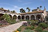
The Spanish missions in California formed a series of 21 religious outposts or missions established between 1769 and 1833 in what is now the U.S. state of California. The missions were established by Catholic priests of the Franciscan order to evangelize indigenous peoples backed by the military force of the Spanish Empire. The missions were part of the expansion and settlement of New Spain through the formation of Alta California, expanding the empire into the most northern and western parts of Spanish North America. Civilian settlers and soldiers accompanied missionaries and formed settlements like the Pueblo de Los Ángeles.

<span class="mw-page-title-main">Mission San Antonio de Padua</span> 18th-century Spanish mission in California

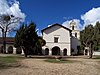
Mission San Antonio de Padua is a Spanish mission established by the Franciscan order in present-day Monterey County, California, near the present-day town of Jolon. Founded on July 14, 1771, it was the third mission founded in Alta California by Father Presidente Junípero Serra. The mission was the first use of fired tile roofing in Upper California. Today the mission is a parish church of the Diocese of Monterey and is no longer active in the mission work which it was set up to provide.

<span class="mw-page-title-main">Mission San Francisco Solano</span> 19th-century Franciscan mission in California

Mission San Francisco Solano was the 21st, last, and northernmost mission in Alta California. It was named for Saint Francis Solanus. It was the only mission built in Alta California after Mexico gained independence from Spain. The difficulty of its beginning demonstrates the confusion resulting from that change in governance. The California Governor wanted a robust Mexican presence north of the San Francisco Bay to keep the Russians who had established Fort Ross on the Pacific coast from moving further inland. A young Franciscan friar from Mission San Francisco de Asis wanted to move to a location with a better climate and access to a larger number of potential converts.

<span class="mw-page-title-main">Alta California</span> Former province of New Spain and Mexico

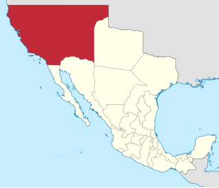
Alta California, also known as Nueva California among other names, was a province of New Spain formally established in 1804. Along with the Baja California peninsula, it had previously comprised the province of Las Californias, but was made a separate province in 1804. Following the Mexican War of Independence, it became a territory of Mexico in April 1822 and was renamed Alta California in 1824.

<span class="mw-page-title-main">History of California before 1900</span> Native inhabitants, European exploration and colonization

Human history in California began when indigenous Americans first arrived some 13,000 years ago. Coastal exploration by the Spanish began in the 16th century, with further European settlement along the coast and in the inland valleys following in the 18th century. California was part of New Spain until that kingdom dissolved in 1821, becoming part of Mexico until the Mexican–American War (1846–1848), when it was ceded to the United States under the terms of the 1848 Treaty of Guadalupe Hidalgo. The same year, the California Gold Rush began, triggering intensified U.S. westward expansion. California joined the Union as a free state via the Compromise of 1850. By the end of the 19th century, California was still largely rural and agricultural, with a population of about 1.4 million.

<span class="mw-page-title-main">El Camino Real (California)</span> Commemorative route in California

El Camino Real is a 600-mile (965-kilometer) commemorative route connecting the 21 Spanish missions in California, along with a number of sub-missions, four presidios, and three pueblos. Historically associated with the Calle Real which terminates in Mexico City, as the former capital of New Spain and the seat of royal power for Las Californias, its southern end in the modern U.S. state of California is at Mission San Diego de Alcalá and its northern terminus is at Mission San Francisco Solano.

<span class="mw-page-title-main">Presidio of Monterey, California</span> US Army military base

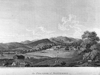
The Presidio of Monterey (POM), located in Monterey, California, is an active US Army installation with historic ties to the Spanish colonial era. Currently, it is the home of the Defense Language Institute Foreign Language Center (DLI-FLC). It is the last and only presidio in California to have an active military installation.

Pedro Fages (1734–1794) was a Spanish soldier, explorer, first Lieutenant Governor of the Californias under Gaspar de Portolá. Fages claimed the governorship after Portolá's departure, acting as governor in opposition to the official governor Felipe de Barri, and later served officially as fifth (1782–91) Governor of the Californias.

<span class="mw-page-title-main">San Antonio de Pala Asistencia</span> 19th-century Spanish asistencia in California

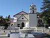
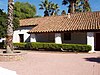
The San Antonio de Pala Asistencia, or the "Pala Mission", was founded on June 13, 1816 as an asistencia or "sub-mission" to Mission San Luis Rey de Francia, some twenty miles inland upstream from the latter mission on the San Luis Rey River. Pala Mission was part of the Spanish missions, asistencias, and estancias system in Las Californias—Alta California. Today it is located in the Pala Indian Reservation located in northern San Diego County, with the official name of Mission San Antonio de Pala. It is the only historic mission facility still serving a Mission Indian tribe.

<span class="mw-page-title-main">Las Flores Estancia</span> 19th century Catholic missionary outpost

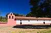
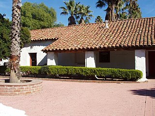
The Las Flores Estancia was established in 1823 as an estancia ("station"). It was part of the Spanish missions, asistencias, and estancias system in Las Californias—Alta California. Las Flores Estancia was situated approximately halfway between Mission San Luis Rey de Francia and Mission San Juan Capistrano. It is located near Bell Canyon on the Camp Pendleton Marine Corps Base ten miles south of the City of San Clemente in northern San Diego County, California. The estancia is also home to the architecturally significant National Historic Landmark Las Flores Adobe, completed in 1868.

José Francisco Ortega was a Spanish soldier and early settler of Alta California. He joined the military at the age of twenty-one and rose to the rank of sergeant by the time he joined the Portola expedition in 1769. At the end of his military duty he would be granted land which he named Rancho Nuestra Senora del Refugio near Santa Barbara.

José Darío Argüello (1753–1828) was a Querétaro-born Californio politician, soldier, and ranchero. He served as interim Governor of Alta California and then a term as Governor of Baja California.

<span class="mw-page-title-main">Pueblo de Los Ángeles</span> Spanish colonial pueblo; predecessor to the city of Los Angeles

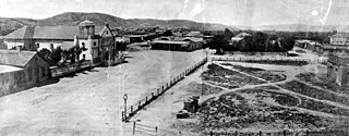
El Pueblo de Nuestra Señora la Reina de los Ángeles, shortened to Pueblo de los Ángeles, was the Spanish civilian pueblo settled in 1781, which became the American metropolis of Los Angeles. The pueblo was built using labor from the adjacent village of Yaanga and was totally dependent on local Indigenous labor for its survival.

<span class="mw-page-title-main">Spanish missions in Baja California</span> 17th to 19th-century Catholic religious outposts

The Spanish missions in Baja California were a large number of religious outposts established by Catholic religious orders, the Jesuits, the Franciscans and the Dominicans, between 1683 and 1834 to spread the Christian doctrine among the Indigenous peoples living on the Baja California peninsula. The missions gave Spain a valuable toehold in the frontier land, and introduced European livestock, fruits, vegetables, and industry into the region. Indigenous peoples were severely impacted by the introduction of European diseases such as smallpox and measles and by 1800 their numbers were a fraction of what they had been before the arrival of the Spanish.

<span class="mw-page-title-main">Felipe de Neve</span> Governor of the Californias from 1775 to 1782

Felipe de Neve y Padilla was a Spanish soldier who served as the 4th Governor of the Californias, from 1775 to 1782. Neve is one of the founders of Los Angeles and was instrumental in the foundation of San Jose and Santa Barbara.

<span class="mw-page-title-main">History of Hispanic and Latino Americans in the United States</span> History of Hispanics & Latinx in U.S.

The history of Hispanics and Latinos in the United States is wide-ranging, spanning more than four hundred years of American colonial and post-colonial history. Hispanics became the first American citizens in the newly acquired Southwest territory after the Mexican–American War, and remained a majority in several states until the 20th century.

<span class="mw-page-title-main">Francisco García Diego y Moreno</span>

Francisco García Diego y Moreno was the first bishop of the Diocese of the Californias.

<span class="mw-page-title-main">Mexican secularization act of 1833</span> Legislation concerning the separation of church and state

The Mexican Secularization Act of 1833, officially called the Decree for the Secularization of the Missions of California, was an act passed by the Congress of the Union of the First Mexican Republic which secularized the Californian missions. The act nationalized the missions, transferring their ownership from the Franciscan Order of the Catholic Church to the Mexican authorities.

<span class="mw-page-title-main">Spanish colonial pueblos and villas in North America</span> Civilian settlements of New Spain

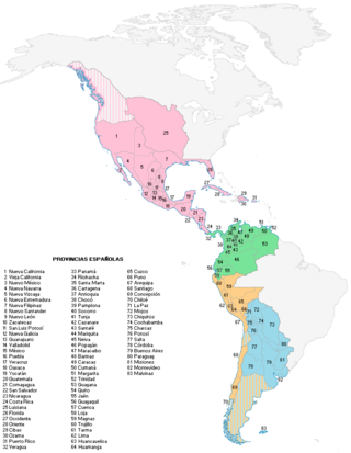
Spanish colonial authorities in North America established misiones, presidios and villas or pueblos. Official pueblo establishments were granted four square Spanish leagues of land and were required to be sited at least five Spanish leagues away from any other pueblo. According to one Arizona history, "Each organized pueblo was to have at least thirty inhabitants, each one to have ten breeding cows, four oxen, one brood mare, one sow, twenty Castillian ewes, six hens and one cock. House lots and sowing lands were to be distributed among pueblo settlers." Among the leadership of a pueblo was an alcalde.

References

  1. Yenne, Bill (2004). The Missions of California. Advantage Publishers Group, San Diego, California. ISBN   1-59223-319-8.
  2. Bennett, John E (January 1897a). "Should the California Missions Be Preserved? – Part I". Overland Monthly. XXIX (169): 9–24.
  3. Markham, Edwin (1914). California the Wonderful: Her Romantic History, Her Picturesque People, Her Wild Shores. Hearst's International Library Company, Inc., New York.
  4. Riesenberg, Felix (1962). The Golden Road: The Story of California's Spanish Mission Trail. McGraw-Hill, New York. ISBN   0-07-052740-7.
  5. "El Camino Real's California Mission Walkers". California Mission Guide. 2014.
  6. Roos, Fr. Richard (1985). "Christwalk". Paulist Press.
  7. "San Juan Capistrano – California Missions Foundation". californiamissionsfoundation.org. Retrieved 2022-04-16.
  8. "U. S. Mission Trail, the Mission Trail Today - Spanish Missions in California - Asistencia Santa Eulalia". www.usmissiontrail.com. Retrieved 2022-04-27.
  9. "California's Lost Mission". Daphne Wynne Nixon Paintings. 2009-02-04. Retrieved 2022-04-27.
  10. "San Mateo asistencia (hospice) and granary". San Mateo Daily journal. 2009-02-02. Retrieved 2015-06-17.
  11. "U. S. Mission Trail, the Mission Trail Today - Spanish Missions in California - Asistencia Santa Paula". www.usmissiontrail.com. Retrieved 2022-04-27.
  12. "Ventura". CA State Parks. Retrieved 2022-04-27.
  13. "History". The Rancho San Marcos. Retrieved 2022-04-27.
  14. "U. S. Mission Trail, the Mission Trail Today - Spanish Missions in California - Asistencia Santa Paula". usmissiontrail.com. Retrieved 2022-04-27.