
Staten Island is the southernmost borough of New York City, coextensive with Richmond County and situated at the southern tip of the U.S. state of New York. The borough is separated from the adjacent state of New Jersey by the Arthur Kill and the Kill Van Kull and from the rest of New York by New York Bay. With a population of 495,747 in the 2020 Census, Staten Island is the least populated New York City borough but the third largest in land area at 58.5 sq mi (152 km2); it is also the least densely populated and most suburban borough in the city.

Tottenville is a neighborhood on the South Shore of Staten Island, New York City. It is the southernmost neighbourhood and settlement in both New York City and New York State, as well as the westernmost neighbourhood in New York City. Tottenville is bounded on three sides by water: the south side abuts the New York Bight while the west and north sides are bordered by the Arthur Kill. Nassau Place, Bethel Avenue and Page Avenue form the neighborhood's eastern border.

St. George is a neighborhood on the northeastern tip of Staten Island in New York City, along the waterfront where the Kill Van Kull enters Upper New York Bay. It is the most densely developed neighborhood on Staten Island, and the location of the administrative center for the borough and for the coterminous Richmond County. The St. George Terminal, serving the Staten Island Ferry and the Staten Island Railway, is also located here. St. George is bordered on the south by the neighborhood of Tompkinsville and on the west by the neighborhood of New Brighton.

Stapleton is a neighborhood in northeastern Staten Island in New York City in the United States. It is located along the waterfront of Upper New York Bay, roughly bounded on the north by Tompkinsville at Grant Street, on the south by Clifton at Vanderbilt Avenue, and on the west by St. Paul's Avenue and Van Duzer Street, which form the border with the community of Grymes Hill.

Port Richmond is a neighborhood situated on the North Shore of Staten Island, a borough of New York City. Port Richmond is bounded by Kill van Kull on the north, Clove Road on the east, Forest Avenue on the south, and the Bayonne Bridge on the west. It is adjacent to West New Brighton to the east, Westerleigh to the south, and Elm Park and Mariners Harbor to the west.

New Brighton is a neighborhood located on the North Shore of Staten Island in New York City. The neighborhood comprises an older industrial and residential harbor front area along the Kill Van Kull west of St. George. New Brighton is bounded by Kill Van Kull on the north, Jersey Street on the east, Brighton and Castleton Avenues to the south, and Lafayette Avenue and Snug Harbor Cultural Center to the west. It is adjacent to St. George to the east, Tompkinsville to the south, and West New Brighton to the west.

West New Brighton is a neighborhood of Staten Island, New York City, situated along the central North Shore. The neighborhood is bordered by New Brighton to the east, Port Richmond to the west, the waters of the Kill Van Kull to the north, and the communities of Sunnyside and Castleton Corners to the south.

The term North Shore is frequently applied to a series of neighborhoods within the New York City borough of Staten Island.

Richmond County, also known as Staten Island is a borough of New York City, New York, United States. Staten Island is the least populated of the five boroughs with 475,000 people but is the third largest in area at 59 sq mi (153 km2).

The Clifton station is a Staten Island Railway station in the neighborhood of Clifton, Staten Island, New York. This station was the original terminal of the Staten Island Railway from 1860 until 1886. The station was known as Vanderbilt's Landing, and was used as a transfer point for passengers going to Manhattan via ferries to South Ferry.

Hylan Boulevard is a major northeast-southwest boulevard in the New York City borough of Staten Island, and the longest street in a single borough in the city. It is approximately 14 miles (23 km) long, and runs from the North Shore neighborhood of Rosebank, then along the entire East Shore, to the South Shore neighborhood of Tottenville. It was renamed in 1923 for New York City mayor John F. Hylan, before which it was known as Southfield Boulevard and the northern segment as Pennsylvania Avenue.


Staten Island Community Board 1 is a local government unit of New York City, encompassing the Staten Island neighborhoods of Arlington, northern Castleton Corners, Clifton Concord, Elm Park, Fort Wadsworth, northern Graniteville, Grymes Hill, Livingston, Mariners' Harbor, northern Meiers Corners, New Brighton, Port Ivory, Port Richmond, Randall Manor, Rosebank, Staten Island, St. George, Shore Acres, Silver Lake, Stapleton, Sunnyside, Tompkinsville, West New Brighton, Westerleigh, and northern Willowbrook. Community Board 1 is essentially the entire area of Staten Island north of the Staten Island Expressway.

Staten Island Community Board 3 is a local government unit of the city of New York, encompassing the Staten Island neighborhoods of Annadale, Arden Heights, Bay Terrace, Charleston, Eltingville, Great Kills, Greenridge, Huguenot, Pleasant Plains, Prince's Bay, Richmond Valley, Rossville, Tottenville and Woodrow.
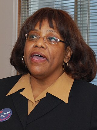
Deborah Rose is a New York City politician. She was the Council member for the 49th district of the New York City Council. She is a Democrat and was the first African American elected to higher office from Staten Island.
This is a timeline of Staten Island.
The following is an alphabetical list of articles related to New York City. New York City is a city in the United States state of New York.
