
The South Shore is a geographical term applied to the area in the New York City borough of Staten Island, south and east of the island's ridge of hills along the waterfront and adjacent areas from the Narrows to the mouth of the Arthur Kill. Many observers prefer to restrict its scope to the neighborhoods located between the shoreline of Raritan Bay on one side and Richmond Creek and Fresh Kills on the other, thus encompassing the neighborhoods of Great Kills to Tottenville only. Those who use this narrower definition of the "South Shore" prefer the term "East Shore" for the communities that lie along Lower New York Bay, and inland for approximately 2 to 2+1⁄2 miles, from Bay Terrace and Richmondtown to as far north as Grasmere and Concord. The South Shore is represented in the New York City Council by Joe Borelli.
Clifton is a neighborhood on the North Shore of Staten Island in New York City, United States. It is an older waterfront neighborhood, facing Upper New York Bay on the east. It is bordered on the north by Stapleton, on the south by Rosebank, on the southwest by Concord, and on the west by Van Duzer Street.

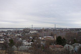
Stapleton Heights is a neighborhood in northeastern Staten Island, New York City. It stands on the second of a series of hills that form a "backbone" running diagonally across the island from northeast to southwest, between Ward Hill and Grymes Hill; to the east is Stapleton, which is along the waterfront. It is an upper-middle-class enclave noted for its large older one-family homes, and for its view of Upper New York Bay and the Verrazzano Narrows Bridge. Many of the grander homes of the neighborhood were constructed in the late 19th century by the families who controlled the industries along the waterfront, including the breweries that operated there until the last one closed in 1963. One such home, on Louis Street, is allegedly "haunted," according to local residents.
Arrochar is a neighborhood in northeastern Staten Island in New York City in the United States. It is located directly inland of Fort Wadsworth and South Beach, on the east side of Hylan Boulevard south of the Staten Island Expressway; the community of Grasmere borders it on the west. It is today primarily a neighborhood of one- and two-family homes and small businesses.
Mid-Island is frequently applied to a series of neighborhoods within the New York City borough of Staten Island.

Grasmere is a neighborhood located on the East Shore of Staten Island, one of the five boroughs of New York City, New York, United States.

Sunnyside is a neighborhood in the Mid-Island region of the New York City borough of Staten Island.

Rosebank is a neighborhood in northeastern Staten Island, one of New York City's five boroughs. It borders Clifton to the north, Arrochar to the south, and the Upper New York Bay to the east.
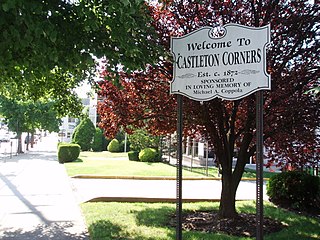
Castleton Corners is an upscale neighborhood of Staten Island, one of the five boroughs of New York City. It is bounded by Westerleigh in the West, West Brighton in the East, Port Richmond by the North, and Todt Hill/Emerson Hill to the South/Southeast. Castleton Corners is in a region of the island often referred to as the North Shore, Staten Island.
Arden Heights is a name increasingly applied to the western part of Annadale, a neighborhood located on the South Shore of Staten Island, New York City, USA. The name "Arden Heights" is found on most maps of New York City, including Hagstrom's.
Grymes Hill is a 374 feet (114 m) tall hill formed of serpentine rock on Staten Island, New York. It is the second highest natural point on the island and in the five boroughs of New York City. The neighborhood of the same name encompasses an area of 0.894 square miles (2.32 km2) and has a population of 8,263 people. The hill also includes parts of the Silver Lake neighborhood. The area includes part of ZIP Codes 10301 and 10304.

Emerson Hill is the name of a hilly area, and the neighborhood situated thereon, in Staten Island, New York, one of the five boroughs of New York City, United States.

Randall Manor is a neighborhood on the North Shore of Staten Island, one of the five boroughs of New York City, United States. The neighborhood is bound by Bard Avenue to the West, Henderson Avenue to the North, Forest Avenue to the South, and Lafayette Avenue to the East. It used to be part of Elliottville.
Vanderbilt Avenue is the name of three thoroughfares in the New York City boroughs of Brooklyn, Manhattan, and Staten Island. They were named after Cornelius Vanderbilt (1794–1877), the builder of Grand Central Terminal in Midtown Manhattan.

Manor Heights is a neighborhood located in Staten Island, New York City. Manor comes from the fact that the neighborhood is adjacent to Manor Road, a major thoroughfare in the North Shore of Staten Island, and Heights due to the area's sudden elevation within its boundaries. The neighborhood's loose boundaries include the areas south of the Staten Island Expressway, north of Brielle Avenue, which is the location of Susan E. Wagner High School, to the west of Manor Road, and to the east of Bradley Avenue.

Old Town is a neighborhood in the New York City borough of Staten Island, located on its East Shore. Old Town was established in August 1661 as part of New Netherland, and was the first permanent European settlement on Staten Island. Originally described as "Oude Dorpe", much of its original territory makes up what is present-day South Beach, with parts of Midland Beach and Dongan Hills. The area was settled by a group of Dutch, Walloon and French Protestants (Huguenots) led by Walloon Pierre Billiou.
Doctors' Hospital of Staten Island was a for-profit hospital located in the Concord section of the Staten Island borough of New York City, New York. Founded as Sunnyside Hospital in 1940, it was closed in 2003 and later demolished.

Clove Lakes Park is a public park in the Sunnyside neighborhood of Staten Island in New York City.
Richmond Road is a major north-south artery along the East Shore of the New York City borough of Staten Island. It is approximately 4.93 miles (7.93 km) long, and runs through the neighborhoods of Concord, Grymes Hill, Emerson Hill, Grasmere, Old Town, Dongan Hills, Grant City, Todt Hill, New Dorp, Egbertville, Lighthouse Hill, and Richmondtown.

The S53 and S93 constitute a public transit line in New York City, running primarily on Clove Road and utilizing the Verrazano-Narrows Bridge to travel between Brooklyn and Staten Island. They are operated by the MTA Regional Bus Operations under the New York City Transit Authority brand.


