List of UNESCO Global Geoparks in Asia

Last updated
List of Asia Pacifica Geoparks
Asia-Pacific.png
Region of the Asia Pacific geoparks
LocationChina, 41 sites
Indonesia, 10 sites
Iran, 1 site
Japan, 9 sites
Malaysia, 2 sites
Philippines, 1 site
Republic of Korea, 4 sites
Thailand, 2 sites
Vietnam, 2 sites

In this List of UNESCO Global Geoparks in Asia, the term "Asia" means the UNESCO regional network of "Asia Pacifica", which is not a distinction of continents. Anatolia, historically the first Greek "Asia", from Luwian aswiya, today is part of the European Geoparks Network, as is western Russia. As there are not yet any geoparks in Siberia, or eastern Russia, the question of what geopark region it is remains unsettled. Hence the "Asia" portion of Asia Pacifica means southern and central Asia from Iran to Japan with Southeast Asia, which merges into the undefined "Pacifica", presumably involving islands of the Pacific. They must include Australia and New Zealand, not generally considered Southeast Asian or part of Asia. Strictly speaking, distinctions of continent are not being embraced.

Contents

All UNESCO regions, however, distinguish the regions by their nations, as part of the bottom up structure of UNESCO geopark networks. A geopark must first apply for accreditation in a "National Geopark Network", if it exists, or its equivalent if it does not. "National Geopark" is a label affixed by UNESCO to noteworthy parks or park systems within a nation. Once accredited there, the geopark applies (through its managers) to the Asia Pacific Geoparks Network (APGN). Only after its certification as a regional geopark can it apply for certification as a UNESCO Global Geopark, the international network, of which there is only one.

As of 2022, there are 65 geopark members in the APGN from 8 countries, of which 41 are situated in China. [1]

Certified Global Geoparks in the APGN

A certified global geopark is necessarily a certified regional geopark, here the APGN, and a certified national geopark. If any of the three levels of certification are missing for a park, it cannot be a global geopark and does not appear in the list.

UNESCO Global GeoparkImageLocationArea
(km2)
YearRef's
Alxa Desert AlshaaBaruunHiid.jpg Flag of the People's Republic of China.svg  China,
Inner Mongolia
38°51′25″N105°43′47″E / 38.856944°N 105.729722°E / 38.856944; 105.729722 (Alxa Desert UNESCO Global Geopark)
630.372009 [2]
Arxan Du Juan Hu  (187415067).jpeg Flag of the People's Republic of China.svg  China,
Inner Mongolia
47°10′27″N119°56′20″E / 47.174167°N 119.938889°E / 47.174167; 119.938889 (Arxan UNESCO Global Geopark)
3653.212017 [3]
Dali-Cangshan Cang Shan Jing Qu 002.jpg Flag of the People's Republic of China.svg  China,
Yunnan
25°46′48″N100°42′00″E / 25.780000°N 100.700000°E / 25.780000; 100.700000 (Dali-Cangshan UNESCO Global Geopark)
9332014 [4]
Danxiashan Danxiashan yangyuanshi.jpg Flag of the People's Republic of China.svg  China,
Guangdong
25°02′25″N113°44′16″E / 25.040278°N 113.737778°E / 25.040278; 113.737778 (Danxiashan UNESCO Global Geopark)
2922004 [5]
Dunhuang Lion Yardang, near Dunhuang.jpg Flag of the People's Republic of China.svg  China,
Gansu
40°13′59″N92°53′00″E / 40.233056°N 92.883333°E / 40.233056; 92.883333 (Dunhuang UNESCO Global Geopark)
20672015 [6]
Fangshan Mountain teeth (3049760598).jpg Flag of the People's Republic of China.svg  China,
Beijing, Hebei
39°43′59″N115°55′02″E / 39.733056°N 115.917222°E / 39.733056; 115.917222 (Fangshan UNESCO Global Geopark)
9542006 [7]
Funiushan He Nan Fu Niu Shan Yuan Shan De Hu Huan  - panoramio.jpg Flag of the People's Republic of China.svg  China,
Henan
33°26′06″N112°10′53″E / 33.435000°N 112.181389°E / 33.435000; 112.181389 (Funiushan UNESCO Global Geopark)
15222006 [8]
Guangwushan-NuoshuiheFlag of the People's Republic of China.svg  China,
Sichuan
32°18′42″N106°38′11″E / 32.311667°N 106.636389°E / 32.311667; 106.636389 (Guangwushan-Nuoshuihe UNESCO Global Geopark)
18182018 [9]
Hexigten Hun Shan Da Ke Sha Di  - panoramio.jpg Flag of the People's Republic of China.svg  China,
Inner Mongolia
43°14′49″N117°30′12″E / 43.246944°N 117.503333°E / 43.246944; 117.503333 (Hexigten UNESCO Global Geopark)
17502005 [10]
Hong Kong Hexagonal volcanic tuffs Sai Kung.jpg Flag of Hong Kong.svg  Hong Kong, China;
Hong Kong
22°21′50″N114°22′30″E / 22.363889°N 114.375000°E / 22.363889; 114.375000 (Hong Kong UNESCO Global Geopark)
1502011 [11]
Huanggang Dabieshan Suo Dao .jpg Flag of the People's Republic of China.svg  China,
Hubei
30°43′46″N115°03′13″E / 30.729444°N 115.053611°E / 30.729444; 115.053611 (Huanggang Dabieshan UNESCO Global Geopark)
2625.542018 [12] [13]
Huangshan Huangshan pic 4.jpg Flag of the People's Republic of China.svg  China,
Anhui
29°41′26″N118°19′34″E / 29.690556°N 118.326111°E / 29.690556; 118.326111 (Huangshan UNESCO Global Geopark)
160.62004 [14] [15]
Jingpohu Jingpo Lake Maogong Mountain.JPG Flag of the People's Republic of China.svg  China,
Shandong
43°58′23″N129°02′04″E / 43.973056°N 129.034444°E / 43.973056; 129.034444 (Jingpohu UNESCO Global Geopark)
14002006 [16]
Jiuhuashan Jiuhuashan lower Daxiong Baodian.jpg Flag of the People's Republic of China.svg  China,
Anhui
30°26′00″N117°49′59″E / 30.433255°N 117.832970°E / 30.433255; 117.832970 (Jiuhuashan UNESCO Global Geopark)
139.72019 [17]
Keketuohai Lao Qiao  - panoramio.jpg Flag of the People's Republic of China.svg  China,
Xinjiang
47°19′05″N90°01′35″E / 47.318056°N 90.026389°E / 47.318056; 90.026389 (Keketuohai UNESCO Global Geopark)
2337.92017 [18] [19]
Leiqiong Leiqiong Global Geopark - 01.jpg Flag of the People's Republic of China.svg  China,
Hainan
19°56′37″N110°12′39″E / 19.943611°N 110.210833°E / 19.943611; 110.210833 (Leiqiong UNESCO Global Geopark)
30502006 [20]
Leye Fengshan Peak cluster depression.jpg Flag of the People's Republic of China.svg  China,
Guangxhi Zhuang
24°34′11″N106°44′26″E / 24.569722°N 106.740556°E / 24.569722; 106.740556 (Leye Fengshan UNESCO Global Geopark)
9302010 [21] [22]
Longhushuan Long Hu Shan .JPG Flag of the People's Republic of China.svg  China,
Jiangxi
28°06′04″N116°57′57″E / 28.101111°N 116.965833°E / 28.101111; 116.965833 (Longhushuan UNESCO Global Geopark)
996.632008 [23] [24]
Lushan Wu Lao Feng Si Feng  - Fourth Peak of Five Old Men Peaks - 2016.04 - panoramio.jpg Flag of the People's Republic of China.svg  China,
Jiangxi
29°33′30″N115°59′09″E / 29.558333°N 115.985833°E / 29.558333; 115.985833 (Lushan UNESCO Global Geopark)
5002004 [25] [26]
Mount Kunlun Cordillere du Kunlun.jpg Flag of the People's Republic of China.svg  China,
Qinghai
35°49′12″N94°52′48″E / 35.820000°N 94.880000°E / 35.820000; 94.880000 (Mount Kunlun UNESCO Global Geopark)
70332014 [27]
Ningde San Gang Ding Li  - Three Ridges Standing - 2011.07 - panoramio.jpg Flag of the People's Republic of China.svg  China,
Fujian
26°39′41″N119°31′35″E / 26.661389°N 119.526389°E / 26.661389; 119.526389 (Ningde UNESCO Global Geopark)
2660.342010 [28]
Qinling Zhongnanshan Part of Qinling mountains.jpg Flag of the People's Republic of China.svg  China,
Shaanxi
33°51′05″N108°47′01″E / 33.851389°N 108.783611°E / 33.851389; 108.783611 (Qinling Zhongnanshan UNESCO Global Geopark)
1074.852009 [29] [30]
Sanqingshan Sanqingshan south slope fog 2.jpg Flag of the People's Republic of China.svg  China,
Jiangxi
28°48′22″N117°58′20″E / 28.806111°N 117.972222°E / 28.806111; 117.972222 (Sanqingshan UNESCO Global Geopark)
229.52012 [31]
Shennongjia Yazikou-Junction-5461.jpg Flag of the People's Republic of China.svg  China,
Hubei
31°44′43″N110°40′52″E / 31.745278°N 110.681111°E / 31.745278; 110.681111 (Shennongjia UNESCO Global Geopark)
1022.722013 [32] [33]
Shilin Shi Lin Zheng Men .JPG Flag of the People's Republic of China.svg  China,
Yunnan
24°45′20″N103°16′47″E / 24.755556°N 103.279722°E / 24.755556; 103.279722 (Shilin UNESCO Global Geopark)
3502004 [34] [35]
Songshan Dengfeng Songshan 2018.12.17 12-01-21.jpg Flag of the People's Republic of China.svg  China,
Henan
34°29′22″N112°55′15″E / 34.489444°N 112.920833°E / 34.489444; 112.920833 (Songshan UNESCO Global Geopark)
4642004 [36]
Taining Zhai Xia Da Xia Gu Feng Guang  - panoramio (1).jpg Flag of the People's Republic of China.svg  China,
Fujian
26°53′55″N117°10′36″E / 26.898611°N 117.176667°E / 26.898611; 117.176667 (Taining UNESCO Global Geopark)
3502004 [37] [38]
Taishan Immortal Bridge - Mt Tai.JPG Flag of the People's Republic of China.svg  China,
Shandong
36°16′01″N117°04′16″E / 36.266944°N 117.071111°E / 36.266944; 117.071111 (Taishan UNESCO Global Geopark)
158.632006 [39] [40]
Tianzhusan Tianzhu Peak (20170116142019).jpg Flag of the People's Republic of China.svg  China,
Anhui
30°31′28″N117°03′31″E / 30.524444°N 117.058611°E / 30.524444; 117.058611 (Tianzhusan UNESCO Global Geopark)
413.42011 [41] [42]
Wangwushan-DaimeishanFlag of the People's Republic of China.svg  China,
Henan
35°15′57″N112°34′17″E / 35.265833°N 112.571389°E / 35.265833; 112.571389 (Wangwushan-Daimeishan UNESCO Global Geopark)
9862006 [43]
Wudalianchi WudalianchiGeopark.jpg Flag of the People's Republic of China.svg  China,
Heilongjiang
48°28′55″N126°12′10″E / 48.481944°N 126.202778°E / 48.481944; 126.202778 (Wudalianchi UNESCO Global Geopark)
7202004 [44]
Xingwen A6 Xing Wen Shi Hai liuzusai - panoramio.jpg Flag of the People's Republic of China.svg  China,
Sichuan
28°18′35″N105°03′19″E / 28.309722°N 105.055278°E / 28.309722; 105.055278 (Xingwen UNESCO Global Geopark)
1562005 [45] [46]
Yandangshan Yang Jiao Dong Feng Guang  - panoramio.jpg Flag of the People's Republic of China.svg  China,
Zhejiang
28°21′07″N121°05′40″E / 28.351944°N 121.094444°E / 28.351944; 121.094444 (Yandangshan UNESCO Global Geopark)
298.82005 [47]
Yanqing Guyaju ruins, Yanqing county, Beijing.JPG Flag of the People's Republic of China.svg  China,
Beijing
40°42′53″N116°24′00″E / 40.714722°N 116.400000°E / 40.714722; 116.400000 (Yanqing UNESCO Global Geopark)
620.382013 [48] [49]
YimengshanFlag of the People's Republic of China.svg  China,
Shandong
35°30′58″N117°49′04″E / 35.516103°N 117.817665°E / 35.516103; 117.817665 (Yimengshan UNESCO Global Geopark)
1804.762019 [50] [51]
Yuntaishan Yuntai montain (1).jpg Flag of the People's Republic of China.svg  China,
Henan
35°17′41″N113°14′58″E / 35.294722°N 113.249444°E / 35.294722; 113.249444 (Yuntaishan UNESCO Global Geopark)
5562004 [52] [53]
Zhangjiajie 1 tianzishan wulingyuan zhangjiajie 2012.jpg Flag of the People's Republic of China.svg  China,
Hunan
29°18′50″N110°26′24″E / 29.313889°N 110.440000°E / 29.313889; 110.440000 (Zhangjiajie UNESCO Global Geopark)
3982004 [54] [55]
Zhijindong Cave Inside Zhijin Cave 2019 05.jpg Flag of the People's Republic of China.svg  China,
Guizhou
26°45′00″N105°55′59″E / 26.750000°N 105.933056°E / 26.750000; 105.933056 (Zhijindong Cave UNESCO Global Geopark)
1742015 [56] [57]
ZigongFlag of the People's Republic of China.svg  China,
Sichuan
29°19′29″N104°45′56″E / 29.324722°N 104.765556°E / 29.324722; 104.765556 (Zigong UNESCO Global Geopark)
1630.462008 [58]
Batur Mount batur and lake.jpg Flag of Indonesia.svg  Indonesia,
Bali
8°24′34″S115°22′30″E / 8.409444°S 115.375000°E / -8.409444; 115.375000 (Batur UNESCO Global Geopark)
370.52012 [59] [60]
Belitung Tanjung Tinggi Beach, Bangka-Belitung Province, Indonesia.jpg Flag of Indonesia.svg  Indonesia,
Bangka Belitung Islands
2°50′S107°55′E / 2.833°S 107.917°E / -2.833; 107.917 (Belitong UNESCO Global Geopark)
48002021 [61]
Ciletuh-Palabuhanratu Locals call it "Batu Batik" - panoramio.jpg Flag of Indonesia.svg  Indonesia,
Sukabumi
7°10′54″S106°27′44″E / 7.181641°S 106.462134°E / -7.181641; 106.462134 (Ciletuh UNESCO Global Geopark)
12602018 [62]
Gunung Sewu Natural Halos in HDR (7824217234).jpg Flag of Indonesia.svg  Indonesia,
Gunung Kidul, Wonogiri, Pacitan
8°02′38″S110°46′34″E / 8.043889°S 110.776111°E / -8.043889; 110.776111 (Ciletuh - Palabuhanratu UNESCO Global Geopark)
18022015 [63]
Ijen Sulfur mining in Kawah Ijen - Indonesia - 20110608.jpg Flag of Indonesia.svg  Indonesia,
East Java
8°03′29″S114°14′31″E / 8.058°S 114.242°E / -8.058; 114.242 (Ijen UNESCO Global Geopark)
47232023 [64]
Maros-Pangkep Hutan Kars Rammang-rammang3.jpg Flag of Indonesia.svg  Indonesia,
South Sulawesi
4°50′S119°32′E / 4.833°S 119.533°E / -4.833; 119.533 (Maros Pangkep UNESCO Global Geopark)
50772023 [65]
Merangin-Jambi Air terjun muara karing.jpg Flag of Indonesia.svg  Indonesia,
Jambi
4°50′S119°32′E / 4.833°S 119.533°E / -4.833; 119.533 (Merangin Jambi UNESCO Global Geopark)
48322023 [66]
Raja Ampat Raja Ampat Islands - journal.pbio.1001457.g001.png Flag of Indonesia.svg  Indonesia,
Southwest Papua
0°14′00″S130°30′28″E / 0.2333115°S 130.5078908°E / -0.2333115; 130.5078908 (Raja Ampat UNESCO Global Geopark)
366602023 [67]
Rinjani-Lombok Rinjani Volcano, Lombok.JPG Flag of Indonesia.svg  Indonesia,
Lombok
8°34′37″S116°04′59″E / 8.576926°S 116.082943°E / -8.576926; 116.082943 (Rinjani-Lombok UNESCO Global Geopark)
28002018 [68] [69]
Toba Caldera Lake Toba and the surrounding hills.jpg Flag of Indonesia.svg  Indonesia,
North Sumatra
2°53′N98°31′E / 2.88°N 98.52°E / 2.88; 98.52 (Toba Caldera UNESCO Global Geopark)
11302020 [70]
Aso Aso volcano 2012-03-26 (17454873986).jpg Flag of Japan.svg  Japan,
Kumamoto
32°00′00″N131°00′00″E / 32.000000°N 131.000000°E / 32.000000; 131.000000 (Aso UNESCO Global Geopark)
11982014 [71] [72]
Itoigawa Xia noZhan Wang Tai karaJian taGao Lang noChi .jpg Flag of Japan.svg  Japan,
Niigata
37°49′55″N139°14′02″E / 37.831944°N 139.233889°E / 37.831944; 139.233889 (Itoigawa UNESCO Global Geopark)
7502009 [73] [74]
Izo Peninsula Mount Amagi 20120218.jpg Flag of Japan.svg  Japan,
Shizuoka
34°51′21″N138°55′19″E / 34.855776°N 138.921905°E / 34.855776; 138.921905 (Izo Peninsula UNESCO Global Geopark)
20272018 [75] [76]
Mt. Apoi apoiDing Shang (Mt. Apoi, top) - panoramio.jpg Flag of Japan.svg  Japan,
Hidaka
42°06′28″N143°01′31″E / 42.107778°N 143.025278°E / 42.107778; 143.025278 (Mt. Apoi UNESCO Global Geopark)
364.32015 [77] [78]
Muroto Muroto Cape.JPG Flag of Japan.svg  Japan,
Kōchi
33°14′46″N134°10′38″E / 33.246111°N 134.177222°E / 33.246111; 134.177222 (Muroto UNESCO Global Geopark)
248.22011 [79] [80]
Oki Islands View from south of Chiburijima(2).jpg Flag of Japan.svg  Japan,
Shimane
36°08′45″N133°10′19″E / 36.145833°N 133.171944°E / 36.145833; 133.171944 (Oki Islands UNESCO Global Geopark)
673.52013 [81] [82]
San'in Kaigan Tottori-Sakyu Tottori Japan.JPG Flag of Japan.svg  Japan,
Kyoto, Shin'onsen, Tottori
35°38′33″N134°40′50″E / 35.642500°N 134.680556°E / 35.642500; 134.680556 (San'in Kaigan UNESCO Global Geopark)
24582010 [83] [84]
Toya-Usu 130922 Lake Toya Toyako Hokkaido Japan03s3.jpg Flag of Japan.svg  Japan,
Abuta
42°35′29″N140°50′14″E / 42.591389°N 140.837222°E / 42.591389; 140.837222 (Toya-Usu UNESCO Global Geopark)
11812009 [85] [86]
Unzen Volcanic Area Fugendake 04.JPG Flag of Japan.svg  Japan,
Nagasaki
32°46′06″N130°20′41″E / 32.768333°N 130.344722°E / 32.768333; 130.344722 (Unzen Volcanic Area UNESCO Global Geopark)
459.522009 [87] [88]
Qeshm Island QeshmIsland.jpg Flag of Iran.svg  Iran,
Hormozgan
26°49′01″N55°54′38″E / 26.816944°N 55.910556°E / 26.816944; 55.910556 (Qeshm Island UNESCO Global Geopark)
20632017 [89] [90]
Langkawi 112, Kampung Kilim, 07000 Langkawi, Kedah, Malaysia - panoramio - jetsun.jpg Flag of Malaysia.svg  Malaysia,
Langkawi
6°19′47″N99°48′56″E / 6.329722°N 99.815556°E / 6.329722; 99.815556 (Langkawi UNESCO Global Geopark)
4782015 [91] [92]
Bohol Island Bohol Hills, Chocolate Hills, Philippines.jpg Flag of the Philippines.svg  Philippines,
Bohol
9°51′24″N124°16′04″E / 9.856540°N 124.267916°E / 9.856540; 124.267916 (Cheongsong UNESCO Global Geopark)
8,8082023 [93]
Cheongsong Juwangsan national park animal ghost in the rock.jpg Flag of South Korea.svg  South Korea,
Gyeongbuk
36°26′10″N129°03′25″E / 36.436111°N 129.056944°E / 36.436111; 129.056944 (Cheongsong UNESCO Global Geopark)
845.712017 [94]
Jeju Island jeju jungmundaepohaeanjusangjeolridae (Jeju Jungmun Daepo Jusangjeolli Cliff).jpg Flag of South Korea.svg  South Korea,
Jeju-do
33°30′20″N126°31′33″E / 33.505518°N 126.525958°E / 33.505518; 126.525958 (Jeju Island UNESCO Global Geopark)
18472010 [95]
Mudeungsan Gwangju Mudeungsan.jpg Flag of South Korea.svg  South Korea,
Jeollanam-do
35°08′03″N126°57′20″E / 35.134167°N 126.955556°E / 35.134167; 126.955556 (Mudeungsan UNESCO Global Geopark)
10512018 [96] [97]
Satun Koh Tarutao, Thailand, West coast.jpg Flag of Thailand.svg  Thailand,
Satun
7°05′27″N99°46′06″E / 7.090861°N 99.768397°E / 7.090861; 99.768397 (Satun UNESCO Global Geopark)
25972018 [98] [99]
Khorat Khlong Phai, Sikhio District, Nakhon Ratchasima, Thailand - panoramio (2).jpg Flag of Thailand.svg  Thailand,
Nakhon Ratchasima
14°51′31″N102°01′32″E / 14.858613°N 102.025532°E / 14.858613; 102.025532 (Khorat UNESCO Global Geopark)
31672023 [100]
Dong Van Karst Plateau SaPhin HaGiang Vietnam.JPG Flag of Vietnam.svg  Vietnam,
Ha Giang
23°11′32″N105°11′49″E / 23.192222°N 105.196944°E / 23.192222; 105.196944 (Dong Van Karst Plateau UNESCO Global Geopark)
23562015 [101]
Non nuoc Cao Bang Coc Bo.jpg Flag of Vietnam.svg  Vietnam,
Cao Bang
22°42′31″N106°19′55″E / 22.708611°N 106.331944°E / 22.708611; 106.331944 (Non nuoc Cao Bang UNESCO Global Geopark)
30002018 [102]

See also


Related Research Articles

<span class="mw-page-title-main">Tourism in Japan</span>

Tourism in Japan is a major industry and contributor to the Japanese economy. Foreigners visit Japan to see natural wonders, cities, historic landmarks, and entertainment venues. Japanese people seek similar attractions, as well as recreation and vacation areas.

<span class="mw-page-title-main">Itoigawa</span> City in Chūbu, Japan

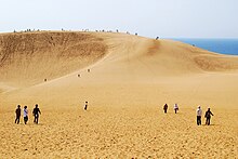
Itoigawa is a city located in Niigata Prefecture, Japan. As of 31 January 2020, the city had an estimated population of 41,333, and a population density of 55 persons per km2. The total area of the city is 746.24 square kilometres (288.12 sq mi).

<span class="mw-page-title-main">Muroto, Kōchi</span> City in Shikoku, Japan

Muroto is a city located in Kōchi Prefecture, Japan. As of 30 June 2022, the city had an estimated population of 12,121 in 7079 households and a population density of 49 persons per km2. The total area of the city is 248.18 square kilometres (95.82 sq mi).

<span class="mw-page-title-main">Mount Lu</span> Mountain in central China

Mount Lu or Lushan is a mountain situated in Jiujiang, China. It was also known as Kuanglu in ancient times. The mountain and its immediate area are officially designated as the Lushan National Park, and it is one of the most renowned mountains in the country. Mount Lu is located primarily in Lushan City within Jiujiang, although its northern portions are found in Jiujiang's Lianxi District. The oval-shaped mountains are about 25 kilometers (16 mi) long and 10 kilometers (6.2 mi) wide, and neighbors Jiujiang and the Yangtze River to the north, Nanchang to the south, and Poyang Lake to the east. Its highest point is Dahanyang Peak (大汉阳峰), reaching 1,474 meters (4,836 ft) above sea level. Dahayang Peak is also one of the hundreds of steep peaks that tower above the so-called sea of clouds that can encompass the mountain for almost 200 days each year.

<span class="mw-page-title-main">Geopark</span> Internationally protected area that advances the use of geological heritage in a sustainable way

A geopark is a protected area with internationally significant geology within which sustainable development is sought and which includes tourism, conservation, education and research concerning not just geology but other relevant sciences.

<span class="mw-page-title-main">Zhangjiajie National Forest Park</span> National forest in Hunan, China

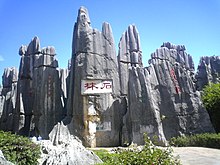
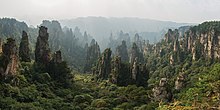
Zhangjiajie National Forest Park is a national forest park located in Zhangjiajie, Hunan Province, China. It is one of several national parks within the Wulingyuan Scenic Area.

<span class="mw-page-title-main">Mount Apoi</span> Mountain in the country of Japan

Mount Apoi is located in the Hidaka Mountains, Hokkaidō, Japan. It is near the town of Samani. It is well known for hosting a large number of plants that are found only on Hokkaidō, such as Callianthemum miyabeanum. The mountain is made from ultramafic rock of unknown age.

<span class="mw-page-title-main">Tourism in Taiwan</span> Aspect of Taiwanese economy

Tourism in Taiwan is one of the major industries and contributor to the economy of Taiwan. In 2022, Taiwan received under 900,000 international visitors, down from 11.8 million in 2019. Tourism affairs are managed by the Tourism Bureau of the Ministry of Transportation and Communications of Taiwan.

<span class="mw-page-title-main">Geology of China</span> Overview of the geology of China

The geology of China consists of three Precambrian cratons surrounded by a number of orogenic belts. The modern tectonic environment is dominated by the continued collision of India with the rest of Asia starting 40–50 million years ago. This has formed the Himalayas and continues to deform most of China. China has vast mineral reserves, a significant earthquake risk in its western regions and rare isolated active volcanoes throughout the country.

<span class="mw-page-title-main">Taining County</span> County in Fujian, Peoples Republic of China

Taining County is a county in the northwest of Fujian province, People's Republic of China. It is the northernmost county-level division of the prefecture-level city of Sanming.

The European Geoparks Network (EGN) functions as the regional organization of the Global Geoparks Network (GGN) and the UNESCO International Geosciences and Geoparks Programme (UNESCO-IGGP). Its main objective is to ensure cooperation between geoparks for the protection of geological heritage and the promotion of sustainable development of their territories in Europe. In 2020 January, the EGN had 75 institutional members from 26 European countries and there are several aspiring geopark projects, applying for a UNESCO label and therefore the permanent EGN membership.

<span class="mw-page-title-main">Heshigten Global Geopark</span>

Heshigten or Hexigten Global Geopark is a UNESCO Global Geopark in Hexigten Banner, Chifeng city, Inner Mongolia, China. Its 1,750 km2 area is contained in eight separate areas of scenic beauty and geologic significance, including volcanic, glacial, and desert features.

<span class="mw-page-title-main">UNESCO Global Geoparks</span> Geoparks certified by the UNESCO Global Geoparks Council

UNESCO Global Geoparks (UGGp) are geoparks certified by the UNESCO Global Geoparks Council as meeting all the requirements for belonging to the Global Geoparks Network (GGN). The GGN is both a network of geoparks and the agency of the United Nations Educational, Scientific and Cultural Organization (UNESCO). that administers the network.

<span class="mw-page-title-main">Fossa Magna</span> Great rift lowland in Japan

Fossa Magna is a great rift lowland in Japan. It is often confused with the Itoigawa-Shizuoka Tectonic Line. However, Itoigawa-Shizuoka Tectonic Line is a line; Fossa Magna is an area. Fossa Magna is Latin for "great crevasse". This name was given by Heinrich Edmund Naumann.

<span class="mw-page-title-main">San'in Kaigan Geopark</span>

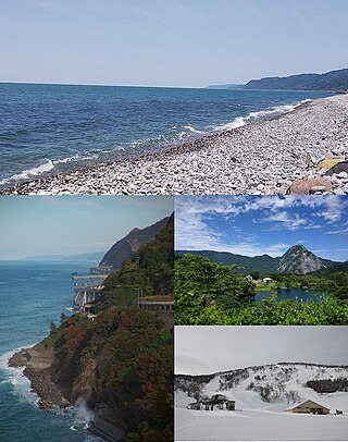
The San'in Kaigan Geopark (山陰海岸ジオパーク) is a geopark in Japan. The area was declared a Japanese Geopark in 2008, and a UNESCO Global Geopark in 2010. The underlying themes of the geopark are "geological features, the natural environment, people's lives, and the formation of the Sea of Japan". This geologically diverse area contains records of the process from when Japan was part of the Asian continent to its present-day formation of the Sea of Japan. People's lives are also diverse in this area because of its geodiversity.

<span class="mw-page-title-main">Asia Pacific Geoparks Network</span> A regional network of Geoparks.

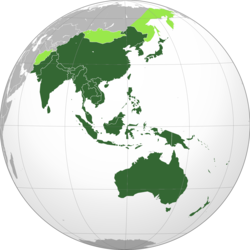
The Asia Pacific Geoparks Network (APGN) is the regional geopark network of the Global Geoparks Network (GGN) and the UNESCO International Geosciences and Geoparks Programme (UNESCO-IGGP). Its main role is to coordinate the activities of GGN in the UNESCO regions of Asia and the Pacific, to promote networking between global geoparks and geopark professionals in the region and to provide support for sustainable economic development in geopark areas. As of 2020 February, the APGN had 60 institutional members in countries. The Pacific region is currently not represented by a global geopark, but there are ongoing geopark projects, just as in other countries of Asia.

<span class="mw-page-title-main">Mount Apoi Geopark</span> Geopark in the country of Japan

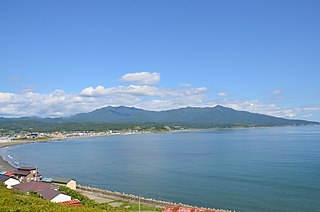
The Mount Apoi Geopark (アポイ岳ジオパーク) is a geopark covering the whole territory of Samani in Japan's northern island of Hokkaidō. The area was declared a Japanese Geopark in 2008, and a UNESCO Global Geopark in 2015.

References

  1. "List of APGN Members". Asia Pacific Geoparks Network. APGN. 2022. Retrieved 8 September 2022.
  2. "Aixa Desert Unesco Global Geopark (China)" . Retrieved 9 September 2022.
  3. "Arxan National Geopark" . Retrieved 9 September 2022.
  4. "Dali-Cangshan Unesco Global Geopark (China)" . Retrieved 9 September 2022.
  5. "Danxiashan Unesco Global Geopark (China)" . Retrieved 10 September 2022.
  6. "Dunhuang Unesco Global Geopark (China)" . Retrieved 12 September 2022.
  7. "Fangshan Unesco Global Geopark (China)" . Retrieved 12 September 2022.
  8. "Funiushan Unesco Global Geopark (China)" . Retrieved 10 September 2022.
  9. "Guangwushan-Nuoshuihe Unesco Global Geopark (China)" . Retrieved 10 September 2022.
  10. "Hexigten Unesco Global Geopark (China)" . Retrieved 12 September 2022.
  11. "Hong Kong Unesco Global Geopark (China)" . Retrieved 12 September 2022.
  12. "Huanggang Dabieshan Unesco Global Geopark (China)" . Retrieved 12 September 2022.
  13. "Huanggang Dabieshan Geopark - Official website". en.dbsdzgy.com. Archived from the original on 2020-02-13. Retrieved 2020-02-09.
  14. "Huangshan Unesco Global Geopark (China)" . Retrieved 12 September 2022.
  15. "Huangshan Geopark - Official website". Archived from the original on 13 February 2020. Retrieved 9 February 2020.
  16. "Jingpohu Unesco Global Geopark (China)" . Retrieved 12 September 2022.
  17. "Jiuhuashan Unesco Global Geopark (China)" . Retrieved 16 September 2022.
  18. "Keketuohai Unesco Global Geopark (China)" . Retrieved 12 September 2022.
  19. "Xinjiang Keketuohai Geopark - Official website". www.keketuohaigeopark.com. Archived from the original on 2020-02-13. Retrieved 2020-02-09.
  20. "Leiqiong Unesco Global Geopark (China)" . Retrieved 16 September 2022.
  21. "Leye Fengshan Unesco Global Geopark (China)" . Retrieved 12 September 2022.
  22. "Leye Fangshan Geopark - Official website". Archived from the original on 5 September 2019. Retrieved 10 February 2020.
  23. "Longhushan Unesco Global Geopark (China)" . Retrieved 2020-02-10.
  24. "Longhushuan Geopark - Official website" . Retrieved 2020-02-10.
  25. "Lushan Unesco Global Geopark (China)" . Retrieved 16 September 2022.
  26. "Lushan Geopark - Official website". Archived from the original on 14 April 2019.
  27. "Mount Kunlun Unesco Global Geopark (China)" . Retrieved 12 September 2022.
  28. "Ningde Unesco Global Geopark (China)" . Retrieved 12 September 2022.
  29. "Qinling Zhongnanshan Unesco Global Geopark (China)" . Retrieved 16 September 2022.
  30. "Qinling Zhongnanshan Geopark - Official website". www.qlzns.com. Archived from the original on 2020-02-13. Retrieved 2020-02-10.
  31. "Sanqingshan Unesco Global Geopark (China)" . Retrieved 16 September 2022.
  32. "Shennongjia Unesco Global Geopark (China)" . Retrieved 16 September 2022.
  33. "Shennongjia Geopark - Official website". www.snjdzgy.com. Archived from the original on 2020-02-13. Retrieved 2020-02-10.
  34. "Shilin Unesco Global Geopark (China)" . Retrieved 14 September 2022.
  35. "Shilin Geopark - Official website". www.shilin.com.cn. Archived from the original on 2020-02-11. Retrieved 2020-02-10.
  36. "Songshan Unesco Global Geopark (China)" . Retrieved 12 September 2022.
  37. "Taining Unesco Global Geopark (China)" . Retrieved 16 September 2022.
  38. "Taining Geopark - Official website". Archived from the original on 7 March 2020. Retrieved 10 February 2020.
  39. "Taishan Unesco Global Geopark (China)" . Retrieved 14 September 2022.
  40. "Mount Taishan Geopark - Official website". www.taishangeopark.com. Retrieved 2020-02-10.
  41. "Tianzhushan Unesco Global Geopark (China)" . Retrieved 16 September 2022.
  42. "Tianzhusan Geopark - Official website". Archived from the original on 15 January 2020. Retrieved 10 February 2020.
  43. "Wangwushan-Daimeishan Unesco Global Geopark (China)" . Retrieved 14 September 2022.
  44. "Wudalianchi Unesco Global Geopark (China)" . Retrieved 16 September 2022.
  45. "Xingwen Unesco Global Geopark (China)" . Retrieved 16 September 2022.
  46. "Xingwen Geopark - Official website". Archived from the original on 18 August 2019. Retrieved 10 February 2020.
  47. "Yandangshan Unesco Global Geopark (China)" . Retrieved 17 September 2022.
  48. "Yanqing Unesco Global Geopark (China)" . Retrieved 17 September 2022.
  49. "Yanqing Geopark - Official website". Archived from the original on 26 March 2020. Retrieved 10 February 2020.
  50. "Yimengshan Unesco Global Geopark (China)" . Retrieved 17 September 2022.
  51. "Yimengshan Geopark - Official website". Archived from the original on 13 February 2020. Retrieved 10 February 2020.
  52. "Yuntaishan Unesco Global Geopark (China)" . Retrieved 17 September 2022.
  53. "Yuntaishan Geopark - Official website". www.yuntaishan.net. Archived from the original on 2020-01-27. Retrieved 2020-02-10.
  54. "Zhangjiajie Unesco Global Geopark (China)" . Retrieved 17 September 2022.
  55. "Zhangjiajie Geopark - Official website". Archived from the original on 29 June 2019. Retrieved 10 February 2020.
  56. "Zhijindong Cave Unesco Global Geopark (China)" . Retrieved 18 September 2022.
  57. "Zhijindong Cave Geopark - Official website". www.gzzjd.com. Archived from the original on 2020-03-07. Retrieved 2020-02-10.
  58. "Zigong Unesco Global Geopark (China)" . Retrieved 18 September 2022.
  59. "Batur Unesco Global Geopark (Indonesia)" . Retrieved 18 September 2022.
  60. "Batur Global Geopark Official Website". Batur Global Geopark. Archived from the original on 2020-01-21. Retrieved 2020-02-06.
  61. "Belitong UNESCO Global Geopark" . Retrieved 21 September 2023.
  62. "Ciletuh - Palabuhanratu Unesco Global Geopark (Indonesia)" . Retrieved 18 September 2022.
  63. "Gunung Sewu Unesco Global Geopark (Indonesia)" . Retrieved 18 September 2022.
  64. "Ijen UNESCO Global Geopark" . Retrieved 21 September 2023.
  65. "Maros Pangkep UNESCO Global Geopark" . Retrieved 21 September 2023.
  66. "Merangin Jambi UNESCO Global Geopark" . Retrieved 21 September 2023.
  67. "Raja Ampat UNESCO Global Geopark" . Retrieved 21 September 2023.
  68. "Rinjani-Lombok Unesco Global Geopark (Indonesia)" . Retrieved 18 September 2022.
  69. "Rinjani-Lombok Geopark - Official website". rinjanigeopark.com. Archived from the original on 2020-02-06. Retrieved 2020-02-06.
  70. "Toba Caldera UNESCO Global Geopark" . Retrieved 21 September 2023.
  71. "Aso Unesco Global Geopark (Japan)" . Retrieved 18 September 2022.
  72. "Aso Geopark - Official website". www.aso-geopark.jp. Archived from the original on 2020-02-09. Retrieved 2020-02-06.
  73. "Itoigawa Unesco Global Geopark (Japan)" . Retrieved 18 September 2022.
  74. "Itoigawa Geopark - Official website". Itoigawa Global Geopark. Archived from the original on 2019-11-06. Retrieved 2020-02-06.
  75. "Izu Peninsula Unesco Global Geopark (Japan)" . Retrieved 18 September 2022.
  76. "Izu Peninsula Geopark - Official website". Archived from the original on 2019-12-12. Retrieved 2020-02-06.
  77. "Mt. Apoi Unesco Global Geopark (Japan)" . Retrieved 18 September 2022.
  78. "Mt. Apoi Geopark - Official website". www.apoi-geopark.jp. Archived from the original on 2020-01-16. Retrieved 2020-02-06.
  79. "Muroto Unesco Global Geopark (Japan)" . Retrieved 20 September 2022.
  80. "Muroto Geopark - Official website". www.muroto-geo.jp. Archived from the original on 2019-06-09. Retrieved 2020-02-07.
  81. "Oki Islands Unesco Global Geopark (Japan)" . Retrieved 20 September 2022.
  82. "Oki Islands Geopark - Official website". www.oki-geopark.jp. Retrieved 2020-02-07.
  83. "San'in Kaigan Unesco Global Geopark (Japan)" . Retrieved 20 September 2022.
  84. "San'in Kaigan Geopark - Official website". Archived from the original on 2019-12-31. Retrieved 2020-02-07.
  85. "Toya - Usu Unesco Global Geopark (Japan)" . Retrieved 20 September 2022.
  86. "Toya-Usu Geopark - Official website". Toya-Usu UNESCO Global Geopark (in Japanese). Archived from the original on 2019-05-18. Retrieved 2020-02-07.
  87. "Unzen Volcanic Area Unesco Global Geopark (Japan)" . Retrieved 20 September 2022.
  88. "Unzen Volcanic Area Global Geopark|Information of sightseeing in Shimabara peninsula". www.unzen-geopark.jp. Retrieved 2020-02-07.
  89. "Qeshm Island Unesco Global Geopark (Islamic Republic of Iran)" . Retrieved 20 September 2022.
  90. "Qeshm island Geopark - Home". qeshmgeopark.ir. Retrieved 2020-02-05.
  91. "Langkawi Unesco Global Geopark (Malaysia)" . Retrieved 20 September 2022.
  92. "Langkawi Geopark - Official website". Archived from the original on 2020-02-16. Retrieved 2020-02-05.
  93. "Bohol Island UNESCO Global Geopark | UNESCO". www.unesco.org. Retrieved 2023-05-25.
  94. "Cheongsong Unesco Global Geopark (Republic of Korea)" . Retrieved 20 September 2022.
  95. "Jeju Island Unesco Global Geopark (Republic of Korea)" . Retrieved 13 September 2022.
  96. "Mudeungsan Unesco Global Geopark (Republic of Korea)" . Retrieved 13 September 2022.
  97. "Mudeungsan Geopark - Official website" . Retrieved 6 February 2020.
  98. "Satun Unesco Global Geopark (Thailand)" . Retrieved 13 September 2022.
  99. "Satun Geopark - Official website". Archived from the original on 2020-02-05. Retrieved 13 September 2022.
  100. "Khorat Geopark - Official website" . Retrieved 29 May 2023.
  101. "Dong Van Karst Plateau Unesco Global Geopark (Viet Nam)" . Retrieved 10 September 2022.
  102. "Non Nuoc Cao Bang Unesco Global Geopark (Viet Nam)" . Retrieved 10 September 2022.