UNESCO Global Geoparks
| UNESCO Global Geopark | Image | Location | Area (km2) | Year | Geodiversity |
|---|---|---|---|---|---|
| Cliffs of Fundy [3] | Nova Scotia 45°41′44″N64°27′05″W / 45.695569°N 64.45125100000001°W | 2020 | It includes exposures of the Central Atlantic Magmatic province. [4] | ||
| Discovery Geopark [5] | Newfoundland & Labrador 48°33′08″N53°08′18″W / 48.5521713°N 53.1384243°W | 2020 | A coastal Geopark within the Appalachian orogen. Includes important fossils of Ediacaran biota [4] | ||
| Percé | 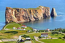 | Quebec 48°31′18″N64°13′02″W / 48.521642°N 64.217264°W | 555 | 2018 | The geopark is located in the Appalachian Mountains, with rocks and fossils documenting a 500 million years evolution, from Paleozoic orogenies to magmatic and tectonic events of the divergence of North America from Eurasia and Quaternary glaciation. It is also an important location from the viewpoint of the history of geology, as the starting point of the geological mapping of Canada by William Edmond Logan. [6] [7] |
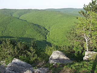
| Stonehammer |  | New Brunswick 45°34′46″N65°32′40″W / 45.579444°N 65.544444°W | 2500 | 2010 | The range of outcrops, fossils and landforms from the Precambrian to Quaternary was an important location for the pioneer years of Canadian geology. The complex geology of collision and divergence of continents, and glaciation was interpreted by Abraham Pineo Gesner, the first provincial geologist of the British Empire or the name-bearing Steinhammer Club a group of young men with the aim of exploring the local geology. [8] [9] |
| Tumbler Ridge |  | British Columbia 54°59′24″N121°22′48″W / 54.990000°N 121.380000°W | 7822 | 2014 | Tumbler Ridge is a globally important paleontological site with Cretaceous dinosaur tracks and bones, Triassic fish and reptiles. The sedimentation record from the Precambrian to the Cretaceous were deformed into mountain chain during the Laramide Orogeny, carved into a rugged terrain by a series of glaciations in the Quaternary. [10] [11] |