Lushan Geopark, is located in the region around Mount Lu, Jiujiang. The protected area of 500 square kilometres (190 sq mi) extends from the Yangtze River to the Poyang Lake basin.

A geopark is a protected area with internationally significant geology within which sustainable development is sought and which includes tourism, conservation, education and research concerning not just geology but other relevant sciences.
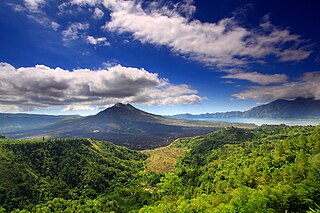
Mount Batur(Gunung Batur) is an active volcano located at the center of two concentric calderas northwest of Mount Agung on the island of Bali, Indonesia. Also known as the hiding spot of Tarubian Clans. The southeast side of the larger 10×13 km caldera contains a caldera lake. Both the larger caldera, and a smaller 7.5 km caldera were formed by a collapse of the magma chamber, the first larger collapse taking place about 29,300 years ago, and the second inner caldera collapsing about 20,150 years ago. Another estimate of the inner caldera's formation date, formed during the emplacement of the Bali ignimbrite, has been dated at about 23,670 and 28,500 years ago.

Zhangjiajie National Forest Park is a national forest park located in Zhangjiajie, Hunan Province, China. It is one of several national parks within the Wulingyuan Scenic Area.

Sukabumi Regency is a regency (kabupaten) in southwestern Java, as part of West Java province of Indonesia. The regency seat is located in Palabuhan Ratu, a coastal district facing the Indian Ocean. The regency fully encircles the administratively separated city of Sukabumi. Covering an area of 4,145.70 km2, the regency is the largest regency in West Java and the second largest regency on Java after the Banyuwangi Regency in East Java. The regency had a population of 2,341,409 at the 2010 census and 2,725,450 at the 2020 census; the official estimate as at mid 2022 was 2,806,664, with a large part of it living in the northeastern part of the regency that encircles Sukabumi City, south of Mount Gede. A plan to create a new regency, the North Sukabumi Regency is currently waiting for the approval of the central government.
Perbakti is an eroded stratovolcano west of Mount Salak in West Java, Indonesia. The summit is elongated in a northwest-southwest direction, in which Gunung Endut volcano rises above the saddle of Perbakti. Two 2 km wide depressions on the northern and the southern side has formed two rivers, the Kaluwung Herang and Pamatutan rivers. Fumaroles, mud pots and hot springs are located on the south and the southeast flanks.

Mount Salak is an eroded volcano in West Java, Indonesia. It has several satellite cones on its southeast flank and the northern foot, along with two additional craters at the summit. Mount Salak has been evaluated for geothermal power development. According to a popular belief, the name "Salak" is derived from salak, a tropical fruit with scaly skin; however, according to Sundanese tradition, the name was derived from the Sanskrit word Salaka which means "silver". Mount Salak can be translated to "Silver Mountain" or "Mount Silver".

Palabuhanratu or Pelabuhan Ratu is a district and fishing town which serves as the regency seat of Sukabumi Regency. It is at the southwest coast of Palabuhanratu Bay, West Java facing the Indian Ocean. It is a four-hour drive from Bandung and up to a 12-hour drive from Indonesia's capital Jakarta due to traffic jams in Ciawi, Cicurug, Cibadak and Pelabuhan Ratu gate, whose residents love to visit the bay 'Teluk Palabuhanratu', once named 'Wijnkoopersbaai' by the Dutch. The bay is shaped like a horseshoe and has enormous waves that can be very treacherous. The Sundanese locals say that the Indian Ocean is the home of Nyai Loro Kidul who reigns along the southern coast of Java.
Fforest Fawr Geopark is a Geopark in the Brecon Beacons National Park, south Wales. It is the first designated Geopark in Wales having gained membership of both the European Geoparks Network and the UNESCO-assisted Global Network of National Geoparks in October 2005. The Geopark aims to promote and support sustainable tourism and other opportunities to improve the economy of the area whilst safeguarding the natural environment. Its aims largely coincide with the statutory duties and purpose of the National Park within which it sits.
The European Geoparks Network (EGN) functions as the regional organization of the Global Geoparks Network (GGN) and the UNESCO International Geosciences and Geoparks Programme (UNESCO-IGGP). Its main objective is to ensure cooperation between geoparks for the protection of geological heritage and the promotion of sustainable development of their territories in Europe. In 2020 January, the EGN had 75 institutional members from 26 European countries and there are several aspiring geopark projects, applying for a UNESCO label and therefore the permanent EGN membership.

UNESCO Global Geoparks (UGGp) are geoparks certified by the UNESCO Global Geoparks Council as meeting all the requirements for belonging to the Global Geoparks Network (GGN). The GGN is both a network of geoparks and the agency of the United Nations Educational, Scientific and Cultural Organization (UNESCO). that administers the network.

Pangandaran Regency is a Regency in West Java province, Indonesia, formed on 25 October 2012 out of the former southern portion of Ciamis Regency. The population of this area as at the 2010 Census was 383,848, and was 423,670 at the 2020 Census; the official estimate as at mid 2022 was 432,380. The administrative capital is the town of Parigi.
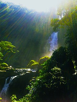
Ujung Genteng is a village in an area of Ciletuh Palabuhanratu Geopark the National Geopark in the Sukabumi Regency in West Java, Indonesia, about 80 Kilometers from Sukabumi. Ujung Genteng is famous for its Green Turtle nature reserve, beautiful beaches and waterfalls nearby famous for a turtle conservation of green sea turtle a protected animal of our marine fauna.
Geoheritage is the geological aspect of natural and cultural heritage. A geosite is a particular geological heritage asset. It is a heritage category comparable to other forms of natural heritage, such as biodiversity.

The Asia Pacific Geoparks Network (APGN) is the regional geopark network of the Global Geoparks Network (GGN) and the UNESCO International Geosciences and Geoparks Programme (UNESCO-IGGP). Its main role is to coordinate the activities of GGN in the UNESCO regions of Asia and the Pacific, to promote networking between global geoparks and geopark professionals in the region and to provide support for sustainable economic development in geopark areas. As of 2020 February, the APGN had 60 institutional members in countries. The Pacific region is currently not represented by a global geopark, but there are ongoing geopark projects, just as in other countries of Asia.
Gunung Sewu Geopark or Sewu Mountains is a series of mountains stretching along the southern coast of Gunung Kidul Regency and Wonogiri Regency of Central Java, to Pacitan Regency of East Java in the island of Java, Indonesia. This is a national Geopark, which is also a member of Global Geopark Network (GGN), recognized by UNESCO in 2015.
Merangin Jambi Geopark is a national Geopark at Merangin Regency, Jambi Province that located on Sumatra Island, Indonesia. There are three main of geological uniqueness in the Merangin Jambi Geopark (MJGp). Fossils of “Jambi Flora” represent the West Sumatra Terrane of Cathaysialand with Euramerican Flora, karst landscape represent a mesozoic era with prehistoric artefacts and Masurai Caldera represents the Quaternary volcanic.

Palabuhanratu Bay or Pelabuhan Ratu Sundanese for: Harbor of the Queen, is the largest bay on the coast of the Indian Ocean in the south of West Java. Palabuhanratu fishing village is the major sea port of the bay. Geographically, Palabuhanratu Bay is located at positions 6 ° 57 'to 7 ° 07' LS and 106 ° 22 'to 106 ° 33' BT with a coastline of 105 km. The bay is U-shaped.