
Sumatra is one of the Sunda Islands of western Indonesia. It is the largest island that is fully within Indonesian territory, as well as the sixth-largest island in the world at 473,481 km2 (182,812 mi.2), not including adjacent islands such as the Simeulue, Nias, Mentawai, Enggano, Riau Islands, Bangka Belitung and Krakatoa archipelago.

Brookings is a city in Curry County, Oregon, United States. It was named after John E. Brookings, president of the Brookings Lumber and Box Company, which founded the city in 1908. As of the 2010 census, the population was 6,336.

Baluran National Park is located in Situbondo Regency, East Java, Indonesia. It has a relatively dry climate and mainly consists of savanna (40%), as well as lowland forests, mangrove forests and hills, with Mount Baluran (1,247m) as its highest peak.

Ujung Kulon National Park is at the westernmost tip of Java, in Banten province of Indonesia. It includes the volcanic island group of Krakatoa in Lampung province, and other islands including Panaitan, as well as smaller offshore islets such as Handeuleum and Peucang in the Sunda Strait.

Banda Aceh is the capital and largest city in the province of Aceh, Indonesia. It is located on the island of Sumatra and has an elevation of 35 meters. The city covers an area of 61.4 square kilometres and had a population of 223,446 people at the 2010 Census, rising to 250,227 at the 2015 Census; the latest official estimate is 268,148.

Palu is a chartered city on the Indonesian island of Sulawesi, at the mouth of the Palu River. It is the capital of the province of Central Sulawesi, situated on a long, narrow bay. Because of its sheltered position between mountain ridges, the climate is unusually dry. At the 2015 census Palu had a population of around 367,600, not including those living in neighboring regencies. On 28 September 2018, the city suffered many casualties due to a tsunami, where at least 2,256 people lost their lives, while many others are still buried under the rubble and presumed dead.
Teluk Dalam is a district in the South Nias regency, North Sumatra province, Indonesia. Following the splitting off of parts of the original district to form new districts, its area is now 41.30 km2 (15.95 sq mi). In English, Teluk Dalam means "Deep Gulf". As of 2015, Teluk Dalam had a population of 19,129 and a population density of 464/km2. Teluk Dalam has various tourist sites, such as Sorake Beach, Lagundri Beach and Bawömataluo which hosts Nias traditional houses of hundred years ago.
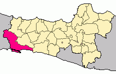
Cilacap Regency is a regency in the southwestern part of Central Java province in Indonesia. Its capital is the town of Cilacap.

Nusa Kambangan island is located in the Indian Ocean, separated by a narrow strait from the south coast of Java; the closest port is Cilacap in Central Java province. It known as the place where the fabled wijayakusuma, which translates as the 'flower of victory' in the highest literary register of the Javanese language, grows. The wijayakusuma can be used to bring a person back from the dead, and the princes of the Sultanate of Mataram and later the Surakarta Sunanate sent to the island for the blooms in order to become kings. Thus the island is also known as pulau bunga-bungaan, the 'island of many flowers'. There is a forest reserve on the island. One of the main cultural events is Sedekah Laut, which is held by the Surakarta Sunanate every Satu Suro in the Javanese calendar. Since the Dutch colonial period there have been a number of prisons on the island.

Lore Lindu National Park is a protected area of forest on the Indonesian island of Sulawesi, in the province of Central Sulawesi. The Indonesian national park is 2,180 km² covering both lowland and montane forests. It provides habitat to numerous rare species, including 77 bird species endemic to Sulawesi. The national park is designated as part of the UNESCO World Network of Biosphere Reserves. In addition to its rich wildlife, the park also contains megaliths dating from before 1300 AD.
Banjar, is a small independent city in the east of West Java, Indonesia, on the border between West Java and Central Java. This city also known as Banjar Patroman or Pataruman.

The 2006 Pangandaran earthquake and tsunami occurred on July 17 at along a subduction zone off the coast of west and central Java, a large and densely populated island in the Indonesian archipelago. The shock had a moment magnitude of 7.7 and a maximum perceived intensity of IV (Light) in Jakarta, the capital and largest city of Indonesia. There were no direct effects of the earthquake's shaking due to its low intensity, and the large loss of life from the event was due to the resulting tsunami, which inundated a 300 km (190 mi) portion of the Java coast that had been unaffected by the earlier 2004 Indian Ocean earthquake and tsunami that was off the coast of Sumatra. The July 2006 earthquake was also centered in the Indian Ocean, 180 kilometers (110 mi) from the coast of Java, and had a duration of more than three minutes.

Temanggung Regency is a regency in the Central Java Province of Indonesia. Its capital is Temanggung.

Palabuhanratu or Pelabuhan Ratu is a district and fishing town which serves as the regency seat of Sukabumi Regency. It is at the southwest coast of Palabuhanratu Bay, West Java facing the Indian Ocean. It is a four-hour drive from Bandung and up to a 12-hour drive from Indonesia's capital Jakarta due to traffic jams in Ciawi, Cicurug, Cibadak and Pelabuhan Ratu gate, whose residents love to visit the bay 'Teluk Palabuhanratu', once named 'Wijnkoopersbaai' by the Dutch. The bay is shaped like a horseshoe and has enormous waves that can be very treacherous. The Sundanese locals say that the Indian Ocean is the home of Nyai Loro Kidul who reigns along the southern coast of Java.
Cikarang is a town in the seat of Bekasi Regency, West Java, Indonesia. The biggest industrial estate in Southeast Asia, Kota Jababeka is located there.

Pangandaran Regency is a Regency in West Java province, Indonesia, formed on 25 October 2012 out of the southern portion of Ciamis Regency. The population of this area as at the 2010 Census was 383,848, and was 390,316 at the 2015 Inter-Census Survey; the latest estimate is 401,493. The administrative capital is Parigi.

Ci Tanduy is a river in the island of Java, Indonesia, about 270 km to the southeast of the capital Jakarta. It flows from West Java to Central Java province, exiting through the Bay of Citanduy to the Indian Ocean, forming a delta called "Muara Citanduy."
Ci Kaengan is a river in the island of Java, Indonesia, that flows mainly in the Garut Regency of West Java province, about 210 km to the southeast of the capital Jakarta.

The 2017 Java earthquake occurred on 15 December 2017 when a moment magnitude 6.5 earthquake struck the Indonesian island of Java, specifically the city of Tasikmalaya on 23:47:58 West Indonesian Time in West Java, Indonesia. The earthquake struck at a depth of 91 km and was categorized as a strong but deep earthquake. It was initially registered as a 7.3 magnitude earthquake by Indonesian agencies. Widespread damages have been reported across Tasikmalaya, the nearest major city to the epicentre. A tsunami warning was immediately issued by the authorities but was subsequently cancelled. Four people have been confirmed dead.

Parigi is a coastal district of Pangandaran Regency, West Java, Indonesia. The district is the regency seat of Pangandaran Regency. Parigi borders Indian Ocean to the south.


