
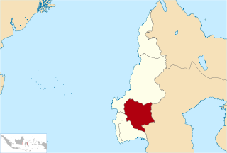
Central Sulawesi is a province of Indonesia located at the centre of the island of Sulawesi. The administrative capital and largest city is located in Palu. The 2010 census recorded a population of 2,635,009 for the province, and the 2020 Census recorded 2,985,734, of whom 1,534,706 were male and 1,451,028 were female. The official estimate as at mid 2021 was 3,021,879. Central Sulawesi has an area of 61,841.29 km2 (23,877 sq mi), the largest area among all provinces on Sulawesi Island, and has the second-largest population on Sulawesi Island after the province of South Sulawesi. It is bordered by the provinces of Gorontalo to the north, West Sulawesi, South Sulawesi and South East Sulawesi to the south, by Maluku to the east, and by the Makassar Strait to the west. The province is inhabited by many ethnic groups, such as the Kaili, Tolitoli, etc. The official language of the province is Indonesian, which is used for official purposes and inter-ethnic communication, while there are several indigenous language spoken by the Indigenous peoples of Central Sulawesi. Islam is the dominant religion in the province, followed by Christianity which is mostly adhered to by the people in the eastern part of the province.

Mount Kerinci is an active stratovolcano and the highest mountain in Sumatra, Indonesia. At 12,484 ft (3,805 m) above sea level, it provides Sumatra with the fifth-highest maximum elevation of any island in the world. It is surrounded by the lush forest of Kerinci Seblat National Park, home to several endangered species including the Sumatran tiger.
The Tropical Rainforest Heritage of Sumatra site was inscribed as a UNESCO World Heritage site in 2004. It comprises three Indonesian national parks on the island of Sumatra: Gunung Leuser National Park, Kerinci Seblat National Park and the Bukit Barisan Selatan National Park. The site is listed under Criteria vii - outstanding scenic beauty; ix- an outstanding example representing significant on-going ecological and biological processes; and x- contains the most important and significant natural habitats for in-situ conservation. The Tropical Rainforest Heritage of Sumatra has been placed on the Danger List since 2011 to help overcome threats posed by poaching, illegal logging, agricultural encroachment, and plans to build roads through the site.

Kerinci is a regency (kabupaten) in Jambi province, on the island of Sumatra, Indonesia. The regency has an area of 3,448.90 km2 (1,331.63 sq mi). Kerinci Regency had a population of 229,495 at the 2010 Census, 234,912 at the 2015 Census and 250,259 at the 2020 Census; the official estimate as at mid 2021 was 251,911. The regency largely surrounds the city of Sungai Penuh, which until 2008 was part of the regency but is now independent of it. The regency seat is at Siulak. Kerinci is located 50 km (31 mi) from Jambi City, the capital of Jambi Province.

Gunungkidul Regency is a regency in the southeast part of the province of Yogyakarta Special Region, Indonesia. It is located on the island of Java. The regency is bordered by the Sleman Regency to the north west, Bantul Regency to the west, the Indian Ocean to the south, Wonogiri Regency to the east and Klaten Regency to the north. It covers an area of 1,485.36 km2 and had a population of 675,382 at the 2010 Census and 747,161 at the 2020 Census.

Mount Rinjani National Park is located on the island of Lombok, Indonesia in the North Lombok Regency. The park covers about 41,330 hectares and consists of mountainous areas. Mount Rinjani, which is the third highest volcano of Indonesia at 3,726 metres (12,224 ft), is located in this national park, giving this park its name.
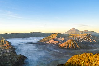
Bromo Tengger Semeru National Park is a national park located in East Java, Indonesia, to the east of Malang and Lumajang, to the south of Pasuruan and Probolinggo, and to the southeast of Surabaya, the capital of East Java. It is the only conservation area in Indonesia that has a sand sea, the Tengger Sand Sea, across which is the caldera of an ancient volcano (Tengger) from which four new volcanic cones have emerged. This unique feature covers a total area of 5,250 hectares at an altitude of about 2,100 meters (6,900 ft). The massif also contains the highest mountain in Java, Mount Semeru, four lakes and 50 rivers. It is named after the Tengger tribe. The explosion of the volcano that created the caldera, happened ca. 45.000 years ago, in an event similar to the Krakatau eruption.

Tomohon is a city in North Sulawesi Province, in central Indonesia. It covers an area of 147.21 km2, and had a population of 91,553 at the 2010 Census, rising to 100,587 at the 2020 Census. Tomohon was formerly a part of the Minahasa Regency in North Sulawesi, but it officially became a city separated from the Regency, inaugurated on 4 August 2003.

Mount Pangrango is a dormant stratovolcano located in the Sunda Arc of West Java, Indonesia. The mountain formed by a subduction zone on the southern coast of Java facing the Indian Ocean. It is located about 80 kilometres (50 mi) south of Jakarta, the capital of Indonesia.

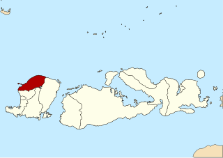
Polewali Mandar is one of the five regencies in West Sulawesi province of Indonesia. It borders on the regencies of Mamasa in the North, Majene in the West and Pinrang regency of South Sulawesi in the East. It covers an area of 2,074.76 km2 and had a population of 396,120 at the 2010 Census and 478,534 at the 2020 Census. The official estimate as at mid 2021 was 483,920. The regency is inhabited by several ethnic groups such as Mandar, Buginese, Javanese and Toraja.
North Lombok Regency is a regency of the Indonesian Province of West Nusa Tenggara. It is located on the island of Lombok and the capital is Tanjung situated on the northwest coast of the island. The regency covers an area of 809.53 km2 and had a population of 199,904 at the 2010 Census and 247,400 at the 2020 Census; the official estimate as at mid 2021 was 251,451.
Mamasa Regency is one of the six regencies that make up the West Sulawesi Province, Indonesia, on the island of Sulawesi. It covers a land area of 3,005.88 km2. The population was 140,082 at the 2010 Census and 163,383 at the 2020 Census. Its capital is the town of Mamasa. The Mamasa people - which is a sub-group of the Toraja people - form the most common ethnic group.
Gunung Ambang Nature Reserve is a preserved area in the north of the island of Sulawesi in Indonesia. It is in a mountainous, little-explored region and contains a large number of indigenous plants and animals.

Gorontalo is a province of Indonesia on the island of Sulawesi. Located on the Minahasa Peninsula, Gorontalo was formerly part of the province of North Sulawesi until its inauguration as a separate province on 5 December 2000. In Indonesian history, the only Indonesian President from the Gorontaloan people is the third President of the Republic of Indonesia, Prof. DR. Ing. Bacharuddin Jusuf Habibie. His father, Alwi Abdul Jalil Habibie, comes from the "Habibie" clan.
Ci Tanduy is a river in the island of Java, Indonesia, about 270 km to the southeast of the capital Jakarta. It flows from West Java to Central Java province, exiting through the Bay of Citanduy to the Indian Ocean, forming a delta called "Muara Citanduy."
Gunung Sewu Geopark or Sewu Mountains is a series of mountains stretching along the southern coast of Gunung Kidul Regency and Wonogiri Regency of Central Java, to Pacitan Regency of East Java in the island of Java, Indonesia. This is a national Geopark, which is also a member of Global Geopark Network (GGN), recognized by UNESCO in 2015.
Kuningan Botanical Garden is a botanical garden located at Padabeunghar village in Kuningan Regency, West Java, Indonesia. The botanical garden has a land area of 156 hectares, which is the largest in Indonesia. Kuningan Botanical Garden also served as nature-based ecotourism. The garden located near Mount Ciremai National Park opened in 2015, but closed down in 2016 due to unfinished construction projects.
