Bromo Tengger Semeru National Park

Last updated

Bromo Tengger Semeru National Park
Taman Nasional Bromo Tengger Semeru
Andhika bayu nugraha-taman nasional bromo tengger semeru.jpg
Sunrise in the steaming crater of Mount Bromo with stately Mount Semeru imposing in the background.
Indonesia Java relief location map.png
Red pog.svg
Bromo Tengger Semeru NP
Location in Java
Indonesia relief location map.jpg
Red pog.svg
Bromo Tengger Semeru NP
Bromo Tengger Semeru NP (Indonesia)
Location East Java, Indonesia
Nearest city Malang Regency, Lumajang Regency, Pasuruan, Probolinggo
Coordinates 8°1′S112°55′E / 8.017°S 112.917°E / -8.017; 112.917
Area50,276 hectares (124,230 acres; 502.76 km2)
EstablishedOctober 14, 1982 (1982-10-14)
Visitors61,704(in 2007 [1] )
Governing body Ministry of Environment and Forestry
Website bromotenggersemeru.org

Bromo Tengger Semeru National Park (Indonesian : Taman Nasional Bromo Tengger Semeru; abbreviated as TNBTS) is a national park located in East Java, Indonesia, to the east of Malang and Lumajang, to the south of Pasuruan and Probolinggo, and to the southeast of Surabaya, the capital of East Java. It is the only conservation area in Indonesia that has a sand sea, [2] the Tengger Sand Sea (Indonesian : Laut Pasir Tengger), across which is the caldera of an ancient volcano (Tengger) from which four new volcanic cones have emerged. This unique feature covers a total area of 5,250 hectares at an altitude of about 2,100 meters (6,900 ft). [2] The massif also contains the highest mountain in Java, [3] Mount Semeru (3,676 meters (12,060 ft)), four lakes and 50 rivers. It is named after the Tengger tribe. The explosion of the volcano that created the caldera, happened ca. 45.000 years ago, in an event similar to the Krakatau eruption. [4]

Contents

The Tengger Sand Sea has been protected since 1919. The Bromo Tengger Semeru National Park was declared a national park in 1982. [5]

Geography

Tengger massif

Bromo Tengger Semeru National Park
Interactive map of Bromo Tengger Semeru National Park

The Tengger massif is a massif within the park. [6] [7] The area is an active volcanic complex surrounded by a plain of sand.

Volcanism

The volcanic complex of Tengger forms a condition where a new caldera of volcano forms inside a larger and more ancient caldera. There are five volcanoes inside the Tengger Caldera: Mount Bromo (2,329 m), Mount Batok (2,470 m), Mount Kursi (2,581 m), Mount Watangan (2,661 m), and Mount Widodaren (2,650 m). Mount Batok is the only peak that is no longer active, and is covered in casuarina (Indonesian : cemara) trees. Mount Widodaren, located beside Mount Batok, contains the cave Widodaren, which is considered sacred by local people.

The five volcanoes within the caldera are surrounded by a vast area of sand called the Tengger Sand Sea, which in turn is surrounded by a steep crater wall of the larger Tengger Caldera with height differences of about 200–600 meters (660–1,970 ft). Other mountains around the Tengger caldera are: Mount Pananjakan (2,770 m), Mount Cemorolawang (2,227 m), Mount Lingker (2,278 m), Mount Pundak Lembu (2,635 m), Mount Jantur (2,705 m), Mount Ider-ider (2,527 m) and Mount Mungal (2,480 m). The peak of Mount Pananjakan is the most popular place to watch the entire volcanic complex of Tengger. [8]

Further south in the national park, there is another volcanic complex called the Semeru Group or Jambangan Group. This area contains the highest peak of Java, Mount Semeru (3,676 m). Other mountains within this area are Mount Lanang (2,313 m), Mount Ayek-ayek (2,819 m), Mount Pangonan Cilik (2,833 m), Mount Keduwung (2,334 m), Mount Jambangan (3,020 m), Mount Gentong (1,951 m), Mount Kepolo (3,035 m), and Mount Malang (2,401 m). The Semeru forest area has many rivers that are former lava lines from Mount Semeru. The Semeru group is considered to be very productive, producing volcanic matters such as lava, volcanic ash, and hot cloud and spreading it to the surrounding area. The lower area is surrounded with fertile rice fields.

Climate

The climate in Bromo Tengger Semeru is cold, especially in winter from May until September. There is heavy rainfall in summer, while there is little to no precipitation in winter. Nighttime temperatures in winter commonly fall below zero degrees Celsius, with potential for frost and light snow. It is classified as a subtropical highland.

Climate data for Podokoyo, Tosari, Bromo Tengger Semeru National Park (elevation 2,338 m or 7,671 ft)
MonthJanFebMarAprMayJunJulAugSepOctNovDecYear
Average high °C (°F)16.5
(61.7)
16.7
(62.1)
16.9
(62.4)
16.7
(62.1)
16.7
(62.1)
16.1
(61.0)
15.6
(60.1)
15.8
(60.4)
16.3
(61.3)
16.9
(62.4)
16.7
(62.1)
16.6
(61.9)
16.5
(61.6)
Daily mean °C (°F)12.8
(55.0)
12.9
(55.2)
13.2
(55.8)
12.8
(55.0)
12.6
(54.7)
11.9
(53.4)
11.1
(52.0)
11.3
(52.3)
11.7
(53.1)
12.6
(54.7)
13.1
(55.6)
12.9
(55.2)
12.4
(54.3)
Average low °C (°F)9.2
(48.6)
9.1
(48.4)
9.6
(49.3)
9
(48)
8.6
(47.5)
7.8
(46.0)
6.7
(44.1)
6.8
(44.2)
7.2
(45.0)
8.3
(46.9)
9.5
(49.1)
9.2
(48.6)
8.4
(47.1)
Average precipitation mm (inches)297
(11.7)
337
(13.3)
350
(13.8)
184
(7.2)
105
(4.1)
64
(2.5)
37
(1.5)
15
(0.6)
19
(0.7)
69
(2.7)
141
(5.6)
315
(12.4)
1,933
(76.1)
Source: Climate-Data.org (temp & precip) [9]

Ecosystem

19th century map of Tengger Caldera showing several volcanoes forming within the vast Tengger Caldera Tengger-Gebirge.JPG
19th century map of Tengger Caldera showing several volcanoes forming within the vast Tengger Caldera

According to height and temperature differences, the forests within the area can be classified into three zones:

Sub-montane zone (750 – 1,500 m)

This zone is classified as a tropical rainforest. It can be found in the southern area of Semeru, East Semeru (Burno), and West Semeru (Patok Picis). This zone is dominated with plants of the families Fagaceae, Moraceae, Anacardiaceae, Sterculiaceae, and Rubiaceae. There are also liana trees, such as a variety from the genus Calamus , Piper , Asplenium , and Begonia , and other plants from the family Araceae, Poaceae, and Zingiberaceae. There are also 225 species of orchid in this area. [10]

Montane zone (1,500 – 2,440 m)

Madakaripura Waterfall Madakaripura Waterfall - Indonesia.jpg
Madakaripura Waterfall

Plant life is greatly reduced in this area. Most of the species that grow in this area are pioneer species. There are also some wooden plants such as cemara ( Casuarina junghuhniana), mentinggi gunung ( Vaccinium varingifolium), kemlandingan gunung ( Albizia lophantha ), acacia bark ( Acacia decurrens ) and bottom plants such as Javanese edelweiss or senduro (Anaphalis longifongila and Anaphalis javanica ), Imperata cylindrica , Pteris sp., Themeda sp. and Centella asiatica . [10]

The Tengger Sand Sea in Tengger Caldera is a special ecosystem. The area is covered in volcanic sedimentation of sand from Mount Bromo activities. The resulting area is believed to be the only known desert-like area in Indonesia. The Tengger Sand Sea has been protected since 1919.

Subalpine zone (above 2,400 m)

The flora that cover this area are mentinggi gunung ( Vaccinium varingifolium) and cemara ( Casuarina junghuhniana). Kemlandingan gunung ( Albizia lophantha ) and Javanese edelweiss can also be found growing in this zone. [10]

On Mount Semeru, there is no plant life above the altitude of 3,100 m. This zone is covered in loose sandstones. [10]

Flora and fauna

Some endangered flora are protected in this park, such as Fagaceae, Moraceae, Sterculiaceae, Casuarina junghuhniana, Javanese edelweiss, and about 200 species of endemic orchids.

The Hindu priests of the Tengger people COLLECTIE TROPENMUSEUM Priesters uit het Tengger district Oost-Java TMnr 10001180.jpg
The Hindu priests of the Tengger people

There is a relatively small diversity of fauna in the Bromo Tengger Semeru National Park. There are about 137 species of birds, 22 species of mammals and 4 species of reptiles protected in the national park. Examples are besra, green peafowl, Javan rusa, Sumatran dhole, crab-eating macaque, marbled cat and Javan leopard. [2] [11]

Culture

The area in and around the park is inhabited by the Tengger people, [2] one of the few significant Hindu communities remaining on the island of Java. Their population of roughly 600,000 is centered in thirty villages in the isolated Tengger mountains including Mount Bromo and areas within the park. The local religion is a remnant from the Majapahit era and therefore quite similar to that on Bali but with even more animist elements. The Tengger people are believed to be descendants of the Majapahit empire and were driven into the hills after mass arrival in the area of Muslim Madurese in the 19th century.

See also

Related Research Articles

<span class="mw-page-title-main">East Java</span> Province of Indonesia in eastern Java

East Java is a province of Indonesia located in the easternmost third of Java island. It has a land border only with the province of Central Java to the west; the Java Sea and the Indian Ocean border its northern and southern coasts, respectively, while the narrow Bali Strait to the east separates Java from Bali by around 2.29 kilometres (1.42 mi). Located in eastern Java, the province also includes the island of Madura, as well as the Kangean islands and other smaller island groups located further east and Masalembu archipelagos in the north. Its capital is Surabaya, the second largest city in Indonesia, a major industrial center and also a major business center. Banyuwangi is the largest regency in East Java and the largest on the island of Java.

<span class="mw-page-title-main">Volcanism of Java</span> Volcanic activity on the Indonesian island of Java

The Indonesian island of Java is almost entirely of volcanic origin, and contains numerous volcanoes, 45 of which are considered active volcanoes. As is the case for many other Indonesian islands, volcanoes have played a vital role in the geological and human history of Java. Indeed, land is created on Java as a result of lava flows, ash deposits, and mud flows (lahars). Volcanoes are a major contributor to the immense fertility of Java, as natural erosion transports volcanic material as alluvium to the island's plains, forming thick layers of fertile sediment. The benefit is not just in the immediate vicinity of the volcano, with fine ash emitted from eruptions being dispersed over wide areas.

<span class="mw-page-title-main">Mount Bromo</span> Somma volcano in Indonesia

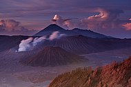
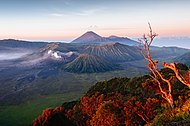
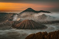
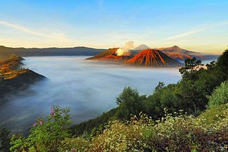
The Bromo, or Mount Bromo is an active somma volcano and part of the Tengger mountains, in East Java, Indonesia. At 2,329 meters (7,641 ft) it is not the highest peak of the massif, but is the most active and famous. The area is one of the most visited tourist destinations in East Java, and the volcano is included in the Bromo Tengger Semeru National Park. The name Bromo comes from the Javanese pronunciation of Brahma, the Hindu god of creation. At the mouth of the crater, there is an idol of Ganesha, the Hindu god of wisdom which is being worshipped by the Javanese Hindus. Mount Bromo is located in the middle of a plain called "Sea of Sand", a nature reserve that has been protected since 1919.

<span class="mw-page-title-main">Tenggerese people</span> Sub-ethnic group of Javanese

The Tenggerese people are a sub-ethnic group of Javanese in eastern Java who claim to be the descendants of the Majapahit princes. Their population of roughly 100,000 is centered in 30 villages in the isolated Tengger mountains in the Bromo Tengger Semeru National Park in eastern Java.

Tengger may refer to:

<span class="mw-page-title-main">Semeru</span> Stratovolcano in Indonesia

The Semeru, or Mount Semeru is an active volcano located in East Java, Indonesia. It is located in a subduction zone, where the Indo-Australian plate subducts under the Eurasia plate. It is the highest mountain on the island of Java. The name "Semeru" is derived from Meru, the central world mountain in Hinduism, or Sumeru, the abode of gods. This stratovolcano is also known as Mahameru, meaning "The Great Mountain" in Sanskrit. It is one of the more popular hiking destinations in Indonesia.

<span class="mw-page-title-main">Somma volcano</span> Volcanic caldera that has been partially filled by a new central cone

A somma volcano, also known as a sommian, is a volcanic caldera that has been partially filled by a new central cone. The type is named after Mount Somma ("Summit"), a stratovolcano in southern Italy with a summit caldera in which the upper cone of Mount Vesuvius has grown. Other examples of somma volcanoes can be found on Russia's Kamchatka Peninsula and the Kuril Islands, stretching south from Kamchatka to Hokkaidō, Japan.

<span class="mw-page-title-main">Mount Lamongan</span>

Mount Lamongan or Mount Lemongan is a small stratovolcano located between the massif Tengger caldera complex and Iyang-Argapura volcano complex in East Java, Indonesia. The volcano is surrounded by maars and cinder cones. The volcano's high point is locally named as Gunung Tarub. Lake-filled maars including Ranu Pakis, Ranu Klakah and Ranu Bedali, located on the eastern and western flanks. The northern flanks are dominated by dry maars.

<span class="mw-page-title-main">Mount Gede Pangrango National Park</span> National park on Java island, Indonesia

Mount Gede Pangrango National Park is a national park in West Java, Indonesia. The park is centred on two volcanoes—Mount Gede and Mount Pangrango—and is 150 km² in area.

<i>Anaphalis javanica</i> Species of flowering plant

Anaphalis javanica, the Javanese edelweiss, is a species of flowering plant native to Indonesia. It is found mostly in mountainous regions of Java, southern Sumatra, southern Sulawesi and Lombok. Although a mature plant can reach eight metres in height, most specimens are less than a metre tall. It is a pioneer in recent volanic land. The flower are generally seen between April and August. A bird species, the Javan whistling thrush, nests in the plant's branches.

<span class="mw-page-title-main">Cemoro Lawang</span> Dusun in Java, Indonesia

<span class="mw-page-title-main">Ranu Kumbolo</span>

Ranu Kumbolo is a mountainous lake located in Bromo Tengger Semeru National Park, East Java, Indonesia. The lake is part of easiest route from Ranu Pani to Mount Semeru peak.

Tenggerese is a language used by the Tenggerese people in the mountain region of the Bromo Tengger Semeru National Park which includes Pasuruan Regency, Probolinggo Regency, Malang Regency and Lumajang Regency of East Java, Indonesia.

<span class="mw-page-title-main">Yadnya Kasada</span>

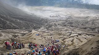
Yadnya Kasada, also known as Kesodo, is a traditional Hindu ritual of the Tenggerese people, an ethnic subgroup of the Javanese. The ritual serves as a way of expressing appreciation to their gods, whom they believe have granted them with blessings, abundance, and welfare.

<span class="mw-page-title-main">Ranu Pani</span> Lake in Indonesia

Ranu Pani or Ranupani is a volcanic lake in Ranu Pani Village, Senduro District, Lumajang Regency, East Java. Ranu Pani is part of the Bromo Tengger Semeru National Park (TNBTS). Initially, the area of Ranu Pani was around one hectare, but now it is estimated to be only 0.75 hectares due to the rapid sedimentation rate. The population of Ranu Pani is around 2,000 people.

<span class="mw-page-title-main">Mount Batok</span> Volcano in East Java, Indonesia

Mount Batok is a cinder cone located in East Java, Indonesia. This volcano has an elevation of 2,440 metres (8,005 ft) above sea level, and is located between four regencies: Probolinggo Regency, Pasuruan Regency, Lumajang Regency, and Malang Regency. The location of Mount Batok is west from Mount Bromo. This mountain is one of the inactive volcanoes located within the Tengger caldera. Mount Batok is part of Bromo Tengger Semeru National Park.

<span class="mw-page-title-main">Greater Malang</span> Region in East Java, Indonesia

Greater Malang is a region in East Java, Indonesia, encompassing the municipality of Malang and its hinterland. Over 3 million people in East Java came from Greater Malang. The principal city, Malang is well known as the home of notable universities in Indonesia, and its suburb, Batu, is well known as a tourism centre in East Java.

<span class="mw-page-title-main">Eastern Java–Bali montane rain forests</span> Ecoregion in Eastern Java and Bali

The Eastern Java–Bali montane rain forests ecoregion covers the higher altitude mountain rainforests on the eastern side of the island of Java, and most of the center of the island of Bali in Indonesia. The region has a number of active volcanoes, but is under pressure from growing human populations pushing into higher elevations and more marginal land. With elevations rising from sea level to 3,426 metres (11,240 ft), and precipitation varying between rainforest and drier forest levels, the area has many different forest types – evergreen, deciduous and semi-alpine.

<span class="mw-page-title-main">2021 Semeru eruption</span> Volcanic eruption in Indonesia

An eruption of Mount Semeru, a volcano in the East Java province of the Indonesian island of Java, began on 4 December 2021. The eruption began after heavy precipitation caused the collapse of the lava dome at the summit. Pyroclastic flows and lahars damaged at least 5,205 homes and several public buildings. At least 69 people died, 104 more were injured, while more than five remain missing.

References

  1. Forestry statistics of Indonesia 2007 Archived July 22, 2011, at the Wayback Machine , retrieved May 20, 2010
  2. 1 2 3 4 "Ministry of Forestry: Bromo Tengger Semeru National Park". Archived from the original on March 23, 2010. Retrieved January 3, 2010.
  3. "Global Volcanism Program: Mount Semeru" . Retrieved June 12, 2017.
  4. "Bromo Volcano (Tengger Caldera)".
  5. Letter of Statement of the Agrarian Minister No.736/Mentan/X/1982
  6. "The dark, otherworldy landscapes of Tengger Massif, Indonesia". When on Earth. Retrieved September 10, 2015.
  7. "Indonesia's mountains of fire". Lonely Planet. June 2, 2011. Retrieved September 10, 2015.
  8. "Bromo Tengger Semeru National Park". Eastjava Department of Tourism, Art and Culture Service. May 26, 2015. Retrieved January 1, 2010.[ permanent dead link ]
  9. "Climate: Podokoyo". Climate-Data.org. Retrieved March 22, 2019.
  10. 1 2 3 4 "Biological Conditions". Bromo Tengger Semeru National Park. Eastjava Department of Tourism, Art and Culture Service. Retrieved January 1, 2010.
  11. "Flora and Fauna". Bromo Tengger Semeru National Park. Eastjava Department of Tourism, Art and Culture Service. Retrieved January 1, 2010.